We Recommend:
Bach Steel - Experts at historic truss bridge restoration.
BridgeHunter.com Phase 1 is released to the public! - Visit Now
Red Mill Bridge

Primary Photographer(s): Nathan Holth and Rick McOmber
Bridge Documented: August 1, 2007
Rural: Cambria County, Pennsylvania: United States
1895 By Builder/Contractor: Variety Iron Works of Cleveland, Ohio
1988
88.0 Feet (26.8 Meters)
90.0 Feet (27.4 Meters)
14 Feet (4.27 Meters)
1 Main Span(s)
117204045930010

View Information About HSR Ratings
Bridge Documentation
View Archived National Bridge Inventory Report - Has Additional Details and Evaluation
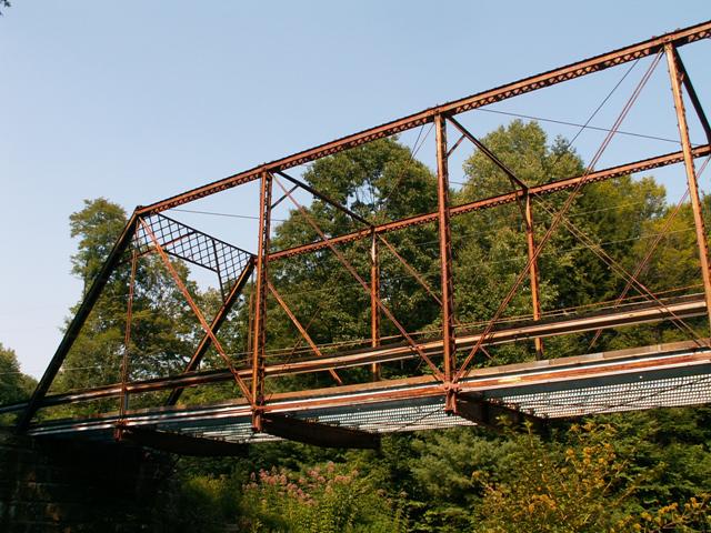
This bridge is extremely rare because it was built by an unusual bridge builder, the Variety Ironworks of Cleveland, Ohio that was apparently not as prolific as some companies since at most only a handful of documented examples of their work appear to remain in the country. The only other bridge currently on this website built by the company is the Maple Rapids Road Bridge in Michigan. The two bridges make a good comparison to identify some of the unusual details this company seemed to use. There are three main items of note. First, the top chord is a standard built-up box beam, but it has lattice on the top instead of the usual plate. Also, unusually, this design for the top chord is not the same on the end posts. End posts are generally the same in design as top chords on a particular bridge. The end post on these two Variety Bridge and Iron Works bridges do not feature the lattice on top and instead has the usual plate. Finally, the sway bracing is a unique design: a lightweight structural element that has a slightly triangular shape to it. Both bridges also feature built-up floor beams that also follow a triangular shape, although this sort of floor beam is not especially unusual for bridges from this period, although it is less common than having a rolled beams for floor beams. The two bridges do differ in that the Red Mill Bridge has a less ornate and more standard lattice design for a portal brace. Also, the Red Mill Bridge has unusual detail at the bottom chord connection at the hip vertical. There really isn't a connection there, and instead, there are just some unusual guides to hold the bottom chord in place.
Clearly, this is an unusual bridge and one of the last surviving examples of a small bridge company's work. This bridge must be preserved. If it is not feasible for it to be restored in place where it can continue to serve the light, rural residential traffic it has handled for the past 100 years, than it could be relocated elsewhere, perhaps for pedestrian use in a park. Perhaps Johnstown, which is a ways south of this bridge, could add this bridge to their rich collection of historic bridges. As the bridge stands, it is in need of restoration, with significant rust present on the bridge, although it is not yet suffered severe damage that would be difficult to correct with a routine restoration that paid attention to retaining historic integrity.
This bridge may be older than the c. 1895 date given by the historic bridge inventory. The Maple Rapids Road Bridge was from 1888, and this bridge looks like it could be from a date closer to that as well. Perhaps a c. 1890 date would be better.
Information and Findings From Pennsylvania's Historic Bridge InventoryDiscussion of Bridge The pin connected, single span, 90'-long, Pratt thru truss bridge is supported on ashlar abutments with stepped, parallel wingwalls. The upper chords have battens connecting the channels, and the built-up, shaped floor beams are original. The cast iron guide blocks for the lower chords at the outside lower panel points are a distinctive detail. The bridge dates stylistically to ca. 1895 The Variety Iron Works was a small Ohio fabricator of standardized design truss bridges from the late 1880s until about 1907. The bridge is historically and technologically significant based on its completeness and non-standard details. Discussion of Surrounding Area The bridge carries 1 lane of a township road over a stream in a sparsely developed, rural area with scattered 20th century residences. South of the bridge is agricultural in character, with undistinguished farm houses ranging in date from the early to the late 20th century. At the northwest quadrant is a 1 story, pressed block residence from ca. 1915. The area does not have the cohesiveness of a potential historic district. Bridge Considered Historic By Survey: Yes |
![]()
Photo Galleries and Videos: Red Mill Bridge
Bridge Photo-Documentation
A collection of overview and detail photos. This photo gallery contains a combination of Original Size photos and Mobile Optimized photos in a touch-friendly popup viewer.Alternatively, Browse Without Using Viewer
![]()
Maps and Links: Red Mill Bridge
Coordinates (Latitude, Longitude):
Search For Additional Bridge Listings:
Bridgehunter.com: View listed bridges within 0.5 miles (0.8 kilometers) of this bridge.
Bridgehunter.com: View listed bridges within 10 miles (16 kilometers) of this bridge.
Additional Maps:
Google Streetview (If Available)
GeoHack (Additional Links and Coordinates)
Apple Maps (Via DuckDuckGo Search)
Apple Maps (Apple devices only)
Android: Open Location In Your Map or GPS App
Flickr Gallery (Find Nearby Photos)
Wikimedia Commons (Find Nearby Photos)
Directions Via Sygic For Android
Directions Via Sygic For iOS and Android Dolphin Browser
USGS National Map (United States Only)
Historical USGS Topo Maps (United States Only)
Historic Aerials (United States Only)
CalTopo Maps (United States Only)

