We Recommend:
Bach Steel - Experts at historic truss bridge restoration.
BridgeHunter.com Phase 1 is released to the public! - Visit Now
Delaware Aqueduct
Roebling's Delaware Aqueduct

Primary Photographer(s): Marc Scotti
Bridge Documented: 2018
Delaware Drive (Former Delaware and Hudson Canal) Over Delaware River
Rural: Sullivan County, New York and Pike County, Pennsylvania: United States
1848 By Builder/Contractor: John A. Roebling and Engineer/Design: John A. Roebling and Russel F. Lord
1987
141.0 Feet (43 Meters)
535.0 Feet (163.1 Meters)
11.5 Feet (3.51 Meters)
4 Main Span(s)
4870001P

View Information About HSR Ratings
Bridge Documentation
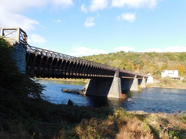
One of the oldest suspension bridges in the United States, this bridge is also noted for its design as an aqueduct, although today it is used as a traditional bridge that is open to traffic with a 10 ton weight limit at the time of writing. The bridge is one of the few in the country that is designated a National Historic Landmark, the highest historic designation in the country. The bridge is also one of the few suspension bridges in the country with a number of suspended spans that is something other than three suspended spans or one suspended span. The bridge is in a state of preservation, which is unusual even when you consider the bridge is not owned by PennDOT. As odd as it may seem, the National Park Service does not exactly have a great preservation track record, with demolitions or severe alterations noted in bridges from Yosemite National Park to the Arlington Memorial Bridge in Washington, DC. Fortunately with this bridge, preservation was undertaken. Ironically, the most recent preservation project actually made it harder to see the structural elements and design of this bridge. This is because the most recent rehabilitation restored the original timber design that once held the waters of the canal, although it retains a design that accomodates vehicular traffic. The timber hides much of the suspension cable elements, but the bridge as seen today is more representative of the bridge's original appearance.
The Delaware and Hudson Canal is the oldest transportation company continuously operating in America. The canal was supplemented and later replaced by the Delaware and Hudson Railroad which still operates, but is owned by Canadian Pacific Railway north of Albany and Norfolk Southern south of Albany.
HistoricBridges.org has a number of older pre-rehab photos of this bridge that have been shared. Currently unorganized, improvement of the galleries is planned in the future as time allows.
View Archived National Bridge Inventory Report - Has Additional Details and Evaluation
View Historic American Engineering Record (HAER) Documentation For This Bridge
HAER Data Pages, PDF - HAER Drawings, PDF
This bridge is tagged with the following special condition(s): Unorganized Photos
![]()
Photo Galleries and Videos: Delaware Aqueduct
Unorganized Photos
Original / Full Size PhotosA collection of overview and detail photos, presented as an unorganized and unlabeled collage and gallery. This gallery offers photos in the highest available resolution and file size in a touch-friendly popup viewer.
Alternatively, Browse Without Using Viewer
![]()
Unorganized Photos
Mobile Optimized PhotosA collection of overview and detail photos, presented as an unorganized and unlabeled collage and gallery. This gallery features data-friendly, fast-loading photos in a touch-friendly popup viewer.
Alternatively, Browse Without Using Viewer
![]()
Maps and Links: Delaware Aqueduct
Coordinates (Latitude, Longitude):
Search For Additional Bridge Listings:
Bridgehunter.com: View listed bridges within 0.5 miles (0.8 kilometers) of this bridge.
Bridgehunter.com: View listed bridges within 10 miles (16 kilometers) of this bridge.
Additional Maps:
Google Streetview (If Available)
GeoHack (Additional Links and Coordinates)
Apple Maps (Via DuckDuckGo Search)
Apple Maps (Apple devices only)
Android: Open Location In Your Map or GPS App
Flickr Gallery (Find Nearby Photos)
Wikimedia Commons (Find Nearby Photos)
Directions Via Sygic For Android
Directions Via Sygic For iOS and Android Dolphin Browser
USGS National Map (United States Only)
Historical USGS Topo Maps (United States Only)
Historic Aerials (United States Only)
CalTopo Maps (United States Only)

