

View Information About HSR Ratings
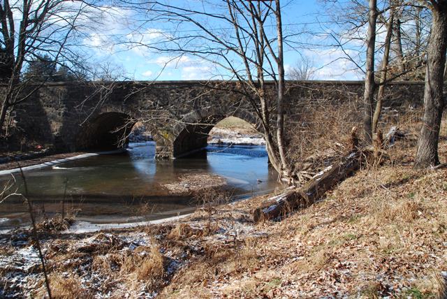
This is a traditional example of a stone arch bridge.
Information and Findings From Pennsylvania's Historic Bridge InventoryDiscussion of Bridge The 2-span, 34'-long stone arch bridge is laid up in rubble coursed field stone spandrel walls and parapets that contrast with the matched ring stones. The parapets have concrete capstones. The intrados was coated with concrete using board forming. The bridge is a late and undistinguished example of a bridge type that is common in the county and region, and it is not historically or technologically significant. There are 50 stone arch bridges dating from 1789 to 1919 in the county. It was built by James M. Smith, a prolific builder of stone arch bridges in the county. Discussion of Surrounding Area The bridge carries a 2 lane road over a stream in a rural area. Modern tract houses are located at two quadrants of the bridge. The Rosenberg Dairy, whose pasture lands are located at two quadrants of the bridge, has only two older buildings visible in the farm complex, including an altered 19th century, stuccoed dwelling and a large frame barn. The majority of the complex is made up of late twentieth century agricultural buildings. The setting does not appear to have historic district potential. Bridge Considered Historic By Survey: No |
This bridge is tagged with the following special condition(s): Unorganized Photos
![]()
![]()
![]()
Coordinates (Latitude, Longitude):
Search For Additional Bridge Listings:
Bridgehunter.com: View listed bridges within 0.5 miles (0.8 kilometers) of this bridge.
Bridgehunter.com: View listed bridges within 10 miles (16 kilometers) of this bridge.
Additional Maps:
Google Streetview (If Available)
GeoHack (Additional Links and Coordinates)
Apple Maps (Via DuckDuckGo Search)
Apple Maps (Apple devices only)
Android: Open Location In Your Map or GPS App
Flickr Gallery (Find Nearby Photos)
Wikimedia Commons (Find Nearby Photos)
Directions Via Sygic For Android
Directions Via Sygic For iOS and Android Dolphin Browser
USGS National Map (United States Only)
Historical USGS Topo Maps (United States Only)
Historic Aerials (United States Only)
CalTopo Maps (United States Only)

© Copyright 2003-2026, HistoricBridges.org. All Rights Reserved. Disclaimer: HistoricBridges.org is a volunteer group of private citizens. HistoricBridges.org is NOT a government agency, does not represent or work with any governmental agencies, nor is it in any way associated with any government agency or any non-profit organization. While we strive for accuracy in our factual content, HistoricBridges.org offers no guarantee of accuracy. Information is provided "as is" without warranty of any kind, either expressed or implied. Information could include technical inaccuracies or errors of omission. Opinions and commentary are the opinions of the respective HistoricBridges.org member who made them and do not necessarily represent the views of anyone else, including any outside photographers whose images may appear on the page in which the commentary appears. HistoricBridges.org does not bear any responsibility for any consequences resulting from the use of this or any other HistoricBridges.org information. Owners and users of bridges have the responsibility of correctly following all applicable laws, rules, and regulations, regardless of any HistoricBridges.org information.
![]()