

View Information About HSR Ratings
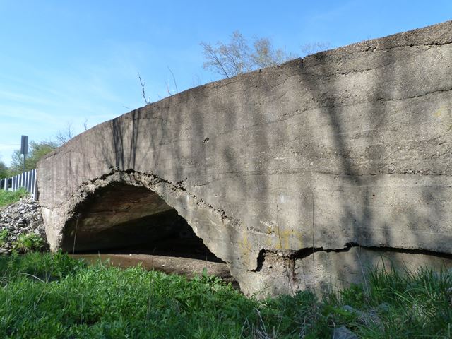
This is an unusual bridge because it has a very simple, undecorated, and crude appearance. There are no architectural details on the arch or the railing. The railing is solid concrete. The concrete of the bridge has a uneven appearance and some cracks that look very old and perhaps relate to the bridge's original construction rather than more contemporary deterioration. The bridge does appear to be unaltered, and the deck has a distinctively substantial arch to it.
Information and Findings From Pennsylvania's Historic Bridge InventoryDiscussion of Bridge The 1913, reinforced concrete, closed spandrel deck arch bridge with bush hammered finish has a vertical curvature that gives the bridge almost a peaked appearance. The unadorned, plain parapets are spalling, particularly at the base of the spandrel wall and in the arch barrel. The spandrel walls also have large cracks. The reinforced concrete deck arch gained popularity quickly in the 1900s, and was used with great frequency in Pennsylvania on local and county roads in the 1910s. This simple, plain bridge has no innovative or distinctive features. Neither the bridge nor its setting and context are historically or technologically noteworthy. Better, more complete examples of the bridge type exist in the county. Discussion of Surrounding Area The bridge carries a one lane of a state road (14' roadway) over a stream in a sparsely developed setting of scrub woods and fields near the intersection of SR 4039 and TR 606. Bridge Considered Historic By Survey: No |
![]()
![]()
![]()
Coordinates (Latitude, Longitude):
Search For Additional Bridge Listings:
Bridgehunter.com: View listed bridges within 0.5 miles (0.8 kilometers) of this bridge.
Bridgehunter.com: View listed bridges within 10 miles (16 kilometers) of this bridge.
Additional Maps:
Google Streetview (If Available)
GeoHack (Additional Links and Coordinates)
Apple Maps (Via DuckDuckGo Search)
Apple Maps (Apple devices only)
Android: Open Location In Your Map or GPS App
Flickr Gallery (Find Nearby Photos)
Wikimedia Commons (Find Nearby Photos)
Directions Via Sygic For Android
Directions Via Sygic For iOS and Android Dolphin Browser
USGS National Map (United States Only)
Historical USGS Topo Maps (United States Only)
Historic Aerials (United States Only)
CalTopo Maps (United States Only)

© Copyright 2003-2026, HistoricBridges.org. All Rights Reserved. Disclaimer: HistoricBridges.org is a volunteer group of private citizens. HistoricBridges.org is NOT a government agency, does not represent or work with any governmental agencies, nor is it in any way associated with any government agency or any non-profit organization. While we strive for accuracy in our factual content, HistoricBridges.org offers no guarantee of accuracy. Information is provided "as is" without warranty of any kind, either expressed or implied. Information could include technical inaccuracies or errors of omission. Opinions and commentary are the opinions of the respective HistoricBridges.org member who made them and do not necessarily represent the views of anyone else, including any outside photographers whose images may appear on the page in which the commentary appears. HistoricBridges.org does not bear any responsibility for any consequences resulting from the use of this or any other HistoricBridges.org information. Owners and users of bridges have the responsibility of correctly following all applicable laws, rules, and regulations, regardless of any HistoricBridges.org information.
![]()