

View Information About HSR Ratings

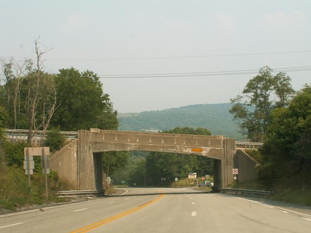
This bridge is an excellent example of rigid-frame technology in Pennsylvania, because the structure retains an excellent level of historic integrity, including original decorative railings. The bridge is also noteworthy for its discernable 6.5% grade. The structure is located in a scenic location where drivers passing under the bridge have an impressive view of the hills in the distance.
Information and Findings From Pennsylvania's Historic Bridge InventoryDiscussion of Bridge The 54'-long and 37' wide, reinforced concrete, rigid frame bridge built in 1938 has flared wingwalls and is finished with Moderne-style balustrades. The earliest extant examples of rigid frame bridge in Pennsylvania date to the late 1920s, and the technology was used for many of the 1937-1950 Pennsylvania Turnpike overpass bridges. This example is not early or technologically innovative. It crosses the former Lincoln Highway, but it was built well after the route was part of the state system of highway. The bridge is not historically or technologically significant, and it is not located in a potential historic district. Its detailing reflects period aesthetics and the moldable qualities of concrete. Neither the bridge nor its setting are historically or technologically significant. Discussion of Surrounding Area The bridge carries a 2 lane road with sidewalks on a horizontal curve over 4 lanes of US 30 in Stoystown. The area is rural and residential in character. The bridge carries SR 281 over the right of way of the US 30. The bridge is not in the Stoystown HD identified by PHMC in 1996. The bridge is not associated with the Lincoln Highway, which was disbanded in 1928. It is assumed, since the overpass required formwork to construct, that this alignment of US 30 dates to 1938. Bridge Considered Historic By Survey: No |
![]()
![]()
This historic bridge has been demolished. This map is shown for reference purposes only.
Coordinates (Latitude, Longitude):
Search For Additional Bridge Listings:
Bridgehunter.com: View listed bridges within 0.5 miles (0.8 kilometers) of this bridge.
Bridgehunter.com: View listed bridges within 10 miles (16 kilometers) of this bridge.
Additional Maps:
Google Streetview (If Available)
GeoHack (Additional Links and Coordinates)
Apple Maps (Via DuckDuckGo Search)
Apple Maps (Apple devices only)
Android: Open Location In Your Map or GPS App
Flickr Gallery (Find Nearby Photos)
Wikimedia Commons (Find Nearby Photos)
Directions Via Sygic For Android
Directions Via Sygic For iOS and Android Dolphin Browser
USGS National Map (United States Only)
Historical USGS Topo Maps (United States Only)
Historic Aerials (United States Only)
CalTopo Maps (United States Only)

© Copyright 2003-2026, HistoricBridges.org. All Rights Reserved. Disclaimer: HistoricBridges.org is a volunteer group of private citizens. HistoricBridges.org is NOT a government agency, does not represent or work with any governmental agencies, nor is it in any way associated with any government agency or any non-profit organization. While we strive for accuracy in our factual content, HistoricBridges.org offers no guarantee of accuracy. Information is provided "as is" without warranty of any kind, either expressed or implied. Information could include technical inaccuracies or errors of omission. Opinions and commentary are the opinions of the respective HistoricBridges.org member who made them and do not necessarily represent the views of anyone else, including any outside photographers whose images may appear on the page in which the commentary appears. HistoricBridges.org does not bear any responsibility for any consequences resulting from the use of this or any other HistoricBridges.org information. Owners and users of bridges have the responsibility of correctly following all applicable laws, rules, and regulations, regardless of any HistoricBridges.org information.
![]()