

View Information About HSR Ratings
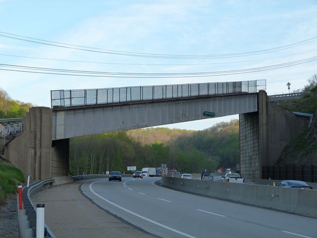
This bridge is located on the segment of the Pennsylvania Turnpike that is not the original segment, but was built in the 1950s. Even so, this bridge is a fairly old bridge in the context of the Interstate Highway System, with a 1952 construction date. The Pennsylvania Turnpike's extensive use of through plate girders for highway overpasses on the Pennsylvania Turnpike is also a bit of an oddity compared to other states. The general design of this particular bridge is standard. The details of the plate girder, and the architectural detailing of the abutments is in keeping with the design of other 1950s Pennsylvania Turnpike bridges, and as such the bridge is a good representative example of these bridges. However, the bridge is also unique because it has a very steep grade and is also built to a heavy skew, these two things making the bridge quite a bit more complex in terms of engineering. It also gives the bridge a strikingly unusual appearance. The unique hilly terrain of Pennsylvania led to many overpass bridges with unusually steep grades. This is simply a particularly exaggerated example. All original Pennsylvania Turnpike bridges are eventually going to be demolished as the entire highway is slowly being widened. Therefore, HistoricBridges.org has selected a sample of the original bridges to document for inclusion on the website to record these structures, which were an integral part of this early limited access highway.
![]()
![]()
![]()
This historic bridge has been demolished. This map is shown for reference purposes only.
Coordinates (Latitude, Longitude):
Search For Additional Bridge Listings:
Bridgehunter.com: View listed bridges within 0.5 miles (0.8 kilometers) of this bridge.
Bridgehunter.com: View listed bridges within 10 miles (16 kilometers) of this bridge.
Additional Maps:
Google Streetview (If Available)
GeoHack (Additional Links and Coordinates)
Apple Maps (Via DuckDuckGo Search)
Apple Maps (Apple devices only)
Android: Open Location In Your Map or GPS App
Flickr Gallery (Find Nearby Photos)
Wikimedia Commons (Find Nearby Photos)
Directions Via Sygic For Android
Directions Via Sygic For iOS and Android Dolphin Browser
USGS National Map (United States Only)
Historical USGS Topo Maps (United States Only)
Historic Aerials (United States Only)
CalTopo Maps (United States Only)

© Copyright 2003-2026, HistoricBridges.org. All Rights Reserved. Disclaimer: HistoricBridges.org is a volunteer group of private citizens. HistoricBridges.org is NOT a government agency, does not represent or work with any governmental agencies, nor is it in any way associated with any government agency or any non-profit organization. While we strive for accuracy in our factual content, HistoricBridges.org offers no guarantee of accuracy. Information is provided "as is" without warranty of any kind, either expressed or implied. Information could include technical inaccuracies or errors of omission. Opinions and commentary are the opinions of the respective HistoricBridges.org member who made them and do not necessarily represent the views of anyone else, including any outside photographers whose images may appear on the page in which the commentary appears. HistoricBridges.org does not bear any responsibility for any consequences resulting from the use of this or any other HistoricBridges.org information. Owners and users of bridges have the responsibility of correctly following all applicable laws, rules, and regulations, regardless of any HistoricBridges.org information.
![]()