We Recommend:
Bach Steel - Experts at historic truss bridge restoration.
BridgeHunter.com Phase 1 is released to the public! - Visit Now
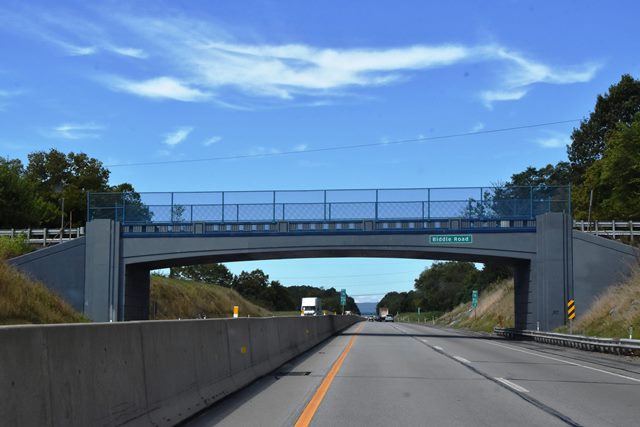
Biddle Road Bridge

Primary Photographer(s): Nathan Holth
Bridge Documented: September 6, 2019
Rural: Cumberland County, Pennsylvania: United States
Not Available or Not Applicable
78.0 Feet (23.8 Meters)
87.0 Feet (26.5 Meters)
22 Feet (6.71 Meters)
1 Main Span(s)
14020

View Information About HSR Ratings
Bridge Documentation
View Archived National Bridge Inventory Report - Has Additional Details and Evaluation
About This Bridge's Photo-Documentation
This expressway overpass bridge was photographed by HistoricBridges.org while driving on the Pennsylvania Turnpike. As such, only overview photos from the expressway lanes are available. Although the many old overpasses built for the Pennsylvania Turnpike are similar in design and appearance, they are being replaced rapidly, and HistoricBridges.org therefore felt it was appropriate to add surviving bridges to the website for this reason.
For a full photo-documentation of a rigid-frame bridge that was on the original section of the turnpike, please see the McClures Gap Road Bridge and for a full photo-documentation of a plate girder overpass bridge, please see the PA-910 Bridge.
About The Pennsylvania Turnpike and Associated Bridges
The Pennsylvania Turnpike is historically significant. The original 160 mile section (completed in 1940) is a designated National Historic Civil Engineering Landmark by ASCE. The original section of the highway, which ran from west of Harrisburg (Carlisle) to east of Pittsburgh (Irwin), formed the first rural, or inter-city limited access highway in the United States (but not North America, since Canada's Queen Elizabeth Way is a few years older) and the largest single highway project in U.S. history at the time. The highway predates the National System of Interstate and Defense Highways (Interstate Freeway system) by around 20 years. Before this "superhighway" was built, most limited access highway development in America was focused on roads within existing urban areas, which were often known as parkways. The Merritt Parkway in Connecticut and the many parkways around New York City are examples of this. These parkways were the first major use of a new bridge type, the concrete rigid-frame bridge. The Pennsylvania Turnpike also chose to use this bridge type for many its overpasses. The turnpike also used through plate girders for many overpasses. As the turnpike was expanded both west and east of the original section, the turnpike continued to use these two bridge types. They also began using steel stringer (multi-beam/girder) bridges, some having riveted built-up beams resembling plate girders.
The use of rigid-frame bridges for limited access highway overpasses tends to appear on only the oldest of freeways, because the design was not economical for the longer spans employed on more modern freeway systems. Similarly, through plate girder bridges are only economical as overpasses for relatively short spans, and for carrying relatively narrow roadways over the Pennsylvania Turnpike. On top of this, because the overpass design includes vertical abutments that are located near to the roadway edge and they also have limited span lengths, these bridges cannot support a widening of the freeway to meet modern Interstate standards. As such, these historically significant bridges are being demolished at a rapid rate and eventually it is expected that few if any of these older overpass bridges will remain in Pennsylvania. By 2019, nearly all the original section bridges had been replaced. The future for similar bridges on newer sections does not look much better with many replaced already. The original turnpike supported two lanes in each direction. The turnpike has been expanding to three lanes in each direction, resulting in these replacements.
![]()
Photo Galleries and Videos: Biddle Road Bridge
Bridge Photo-Documentation
Original / Full Size PhotosA collection of overview and detail photos. This gallery offers photos in the highest available resolution and file size in a touch-friendly popup viewer.
Alternatively, Browse Without Using Viewer
![]()
Bridge Photo-Documentation
Mobile Optimized PhotosA collection of overview and detail photos. This gallery features data-friendly, fast-loading photos in a touch-friendly popup viewer.
Alternatively, Browse Without Using Viewer
![]()
Maps and Links: Biddle Road Bridge
Coordinates (Latitude, Longitude):
Search For Additional Bridge Listings:
Bridgehunter.com: View listed bridges within 0.5 miles (0.8 kilometers) of this bridge.
Bridgehunter.com: View listed bridges within 10 miles (16 kilometers) of this bridge.
Additional Maps:
Google Streetview (If Available)
GeoHack (Additional Links and Coordinates)
Apple Maps (Via DuckDuckGo Search)
Apple Maps (Apple devices only)
Android: Open Location In Your Map or GPS App
Flickr Gallery (Find Nearby Photos)
Wikimedia Commons (Find Nearby Photos)
Directions Via Sygic For Android
Directions Via Sygic For iOS and Android Dolphin Browser
USGS National Map (United States Only)
Historical USGS Topo Maps (United States Only)
Historic Aerials (United States Only)
CalTopo Maps (United States Only)

