

View Information About HSR Ratings
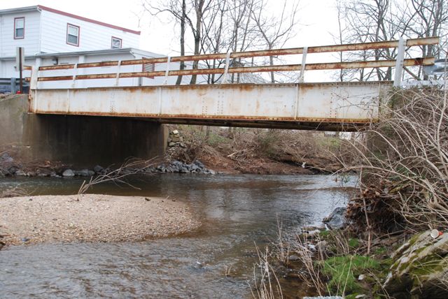
This short through plate girder bridge has an unusual appearance because its already shallow girders are positioned so that they barely come above the deck level. The bridge almost looks like a deck plate girder. The bridge appears to retain good historic integrity with no major alterations to the superstructure observed. The National Bridge Inventory lists a 1950 construction date, but the Historic Bridge Inventory felt that date was incorrect and that a ca. 1920 date is more appropriate. 1950 would be unusually late for a bridge of this type and roadway width to be built.
Information and Findings From Pennsylvania's Historic Bridge InventoryDiscussion of Bridge The bridge carries a 2 lane road over a stream in a forested setting on the south side of Denver Borough. The bridge is located several hundred feet north of the Bucher Thal Historic District (listed 12/31/87) and is not within the district boundaries. The Bucher Thal Historic District is an 18th and 19th-century grist mill-centered rural mill hamlet. The district nomination excludes 20th century development. Discussion of Surrounding Area The single span, 47'-long, steel thru girder bridge dates stylistically to ca. 1920. It is on concrete abutments with wingwalls. The metal railings are fixed to the top of the girders, which barely rise above the top of the open grid steel deck. Rolled floorbeams and stringers support the deck. The bridge is a small, representative example of its type, and is neither historically nor technologically distinguished individually. Thru girder bridges are a common bridge type in widespread use from the 1870s through the 1950s. Based on its date of construction, the bridge is not historically associated with the nearby Bucher Thal Historic District. Bridge Considered Historic By Survey: No |
![]()
![]()
![]()
Coordinates (Latitude, Longitude):
Search For Additional Bridge Listings:
Bridgehunter.com: View listed bridges within 0.5 miles (0.8 kilometers) of this bridge.
Bridgehunter.com: View listed bridges within 10 miles (16 kilometers) of this bridge.
Additional Maps:
Google Streetview (If Available)
GeoHack (Additional Links and Coordinates)
Apple Maps (Via DuckDuckGo Search)
Apple Maps (Apple devices only)
Android: Open Location In Your Map or GPS App
Flickr Gallery (Find Nearby Photos)
Wikimedia Commons (Find Nearby Photos)
Directions Via Sygic For Android
Directions Via Sygic For iOS and Android Dolphin Browser
USGS National Map (United States Only)
Historical USGS Topo Maps (United States Only)
Historic Aerials (United States Only)
CalTopo Maps (United States Only)

© Copyright 2003-2026, HistoricBridges.org. All Rights Reserved. Disclaimer: HistoricBridges.org is a volunteer group of private citizens. HistoricBridges.org is NOT a government agency, does not represent or work with any governmental agencies, nor is it in any way associated with any government agency or any non-profit organization. While we strive for accuracy in our factual content, HistoricBridges.org offers no guarantee of accuracy. Information is provided "as is" without warranty of any kind, either expressed or implied. Information could include technical inaccuracies or errors of omission. Opinions and commentary are the opinions of the respective HistoricBridges.org member who made them and do not necessarily represent the views of anyone else, including any outside photographers whose images may appear on the page in which the commentary appears. HistoricBridges.org does not bear any responsibility for any consequences resulting from the use of this or any other HistoricBridges.org information. Owners and users of bridges have the responsibility of correctly following all applicable laws, rules, and regulations, regardless of any HistoricBridges.org information.
![]()