

View Information About HSR Ratings
This abandoned plate girder highway bridge has fairly large girder spans.
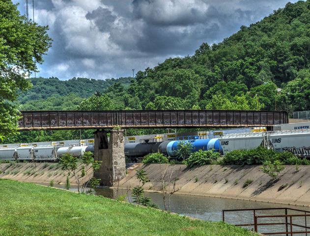
Information and Findings From Pennsylvania's Historic Bridge InventoryDiscussion of Bridge The 3 span bridge is composed of 2 built up thru girder spans (2 @ 118') built in 1915 and a concrete slab approach span (1 @ 29'), placed in 1975. The thru girder spans have built-up floorbeams with a concrete jack arch deck. A cantilevered sidewalk with a metal railing is placed to the east side. The bridge is supported on a concrete abutment, a concrete bent, and an ashlar pier. The thru girder bridge is an example of a very common bridge type with no individually distinguishing features or details. The bridge's significance is in association with the development of the PHMC-determined eligible PRR Main Line. It dates from the line's period of significance and it is associated with efforts to improve the safety and efficiency of the line by improving grade crossings. The bridge was designed by the railroad's engineering department and fabricated by the Fort Pitt Bridge Works. Discussion of Surrounding Area The viaduct carries a 2 lane street and sidewalk over 3 active tracks, a stream, and a local street to the west of Conrail's main yard in the Pittsburgh district. The Conrail line is the former Pennsylvania RR Main Line that has been determined eligible by PHMC (9/14/93). The line is significant for its historic role as an important east-west through route established in the 1850s. Bridge Considered Historic By Survey: Yes |
This bridge is tagged with the following special condition(s): Unorganized Photos
![]()
![]()
![]()
Coordinates (Latitude, Longitude):
Search For Additional Bridge Listings:
Bridgehunter.com: View listed bridges within 0.5 miles (0.8 kilometers) of this bridge.
Bridgehunter.com: View listed bridges within 10 miles (16 kilometers) of this bridge.
Additional Maps:
Google Streetview (If Available)
GeoHack (Additional Links and Coordinates)
Apple Maps (Via DuckDuckGo Search)
Apple Maps (Apple devices only)
Android: Open Location In Your Map or GPS App
Flickr Gallery (Find Nearby Photos)
Wikimedia Commons (Find Nearby Photos)
Directions Via Sygic For Android
Directions Via Sygic For iOS and Android Dolphin Browser
USGS National Map (United States Only)
Historical USGS Topo Maps (United States Only)
Historic Aerials (United States Only)
CalTopo Maps (United States Only)

© Copyright 2003-2025, HistoricBridges.org. All Rights Reserved. Disclaimer: HistoricBridges.org is a volunteer group of private citizens. HistoricBridges.org is NOT a government agency, does not represent or work with any governmental agencies, nor is it in any way associated with any government agency or any non-profit organization. While we strive for accuracy in our factual content, HistoricBridges.org offers no guarantee of accuracy. Information is provided "as is" without warranty of any kind, either expressed or implied. Information could include technical inaccuracies or errors of omission. Opinions and commentary are the opinions of the respective HistoricBridges.org member who made them and do not necessarily represent the views of anyone else, including any outside photographers whose images may appear on the page in which the commentary appears. HistoricBridges.org does not bear any responsibility for any consequences resulting from the use of this or any other HistoricBridges.org information. Owners and users of bridges have the responsibility of correctly following all applicable laws, rules, and regulations, regardless of any HistoricBridges.org information.
![]()