We Recommend:
Bach Steel - Experts at historic truss bridge restoration.
BridgeHunter.com Phase 1 is released to the public! - Visit Now
Cementon Bridge

Primary Photographer(s): Nathan Holth and Rick McOmber
Bridge Documented: May 30, 2010 and November 2, 2019
Main Street / 21st Street (PA-329) Over Lehigh River and Railroad
Cementon: Lehigh County, Pennsylvania and Northampton County, Pennsylvania: United States
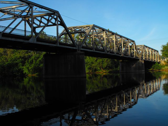
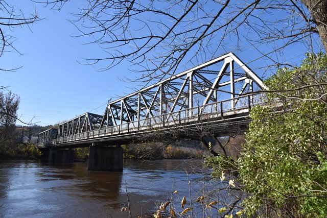
Metal 7 Panel Rivet-Connected Pratt Through Truss, Fixed and Approach Spans: Metal Through Girder, Fixed
1933 By Builder/Contractor: Unknown and Engineer/Design: Pennsylvania State Highway Department
Not Available or Not Applicable
159.0 Feet (48.5 Meters)
575.2 Feet (175.3 Meters)
22 Feet (6.71 Meters)
3 Main Span(s) and 1 Approach Span(s)
39032901300882

View Information About HSR Ratings
Bridge Documentation
This bridge's future is at risk!
Bridge Status: This historic bridge is slated for demolition and replacement!View Archived National Bridge Inventory Report - Has Additional Details and Evaluation
This bridge is an excellent example of a state standard plan through truss bridge in Pennsylvania, as well as a good example of a standard highway plate girder span. The bridge has three through truss spans and one through plate girder approach span. The bridge retains excellent historic integrity, including all original railings. Very minor repairs/alterations were observed such as a plate bolted to a vertical member, but none diminish the overall design and materials of the bridge.
PennDOT has been trying to get this bridge demolished and replaced with an ugly slab of concrete. Fortunately, the funding was canceled and so the project may be delayed for a few years at most. Perhaps instead, PennDOT should consider the less costly and preservation-promoting alternative of rehabilitating this bridge for continued vehicular use. Structurally, there is nothing major wrong with this bridge at all, and it could certainly be rehabilitated for far less than the cost of replacement.
Standard plan truss bridges such as this have been all been discarded by the Historic Bridge Inventory as not eligible for the National Register of Historic Places. However, despite some rehabilitation projects, many of these bridges are also being demolished, and they are becoming less common. Larger examples, such as this multi-span bridge at Cementon stand out as more noteworthy than smaller examples. Regardless of their National Register eligibility, these bridges do have heritage value and a great deal of aesthetic value as well. They are sturdy bridges with decent deck width. Their rehabilitation and preservation is generally less than the cost of replacement, and promotes the preservation of Commonwealth heritage and beauty. They should not be demolished.
Information and Findings From Pennsylvania's Historic Bridge InventoryDiscussion of Bridge The 4-span, 575'-long bridge consists of 3 identical Pratt thru truss spans and one built-up thru girder span, all supported on a concrete substructure. A sidewalk is cantilevered from one side of the bridge. Constructed in 1933 by the state highway department, the rivet-connected truss is a large but relatively late example of the truss technology that was developed in the late-19th century and was used with great frequency through the first 3 decades of the 20th century. The bridge is not historically or technologically significant. The bridge was built after the period of significance of the Lehigh Canal Historic District and is thus not a contributing resource to it. Discussion of Surrounding Area The Cementon bridge carries a 2 lane street and a sidewalk over the Lehigh River and a filled-in section of the Lehigh Canal between Cementon and the Borough of Northampton. The towns are comprised of mixed 20th century structures of residential, commercial and industrial use. The areas of town contiguous to the bridge do not appear to have historic district potential. The Lehigh Canal Historic District, listed 12/17/1979, is the right-of-way of the old Lehigh Canal along the river's north bank. The district has a period of significance from 1840 to 1931, the active years of the canal. Bridge Considered Historic By Survey: Initially, No, But Inventory Lists As Eligible in 2001 |
This bridge is tagged with the following special condition(s): Unorganized Photos
![]()
Photo Galleries and Videos: Cementon Bridge
Bridge Photo-Documentation
Original / Full Size PhotosA collection of overview and detail photos. This gallery offers photos in the highest available resolution and file size in a touch-friendly popup viewer.
Alternatively, Browse Without Using Viewer
![]()
Bridge Photo-Documentation
Mobile Optimized PhotosA collection of overview and detail photos. This gallery features data-friendly, fast-loading photos in a touch-friendly popup viewer.
Alternatively, Browse Without Using Viewer
![]()
2019 Additional Unorganized Photos
Original / Full Size PhotosA supplemental collection of photos that are from additional visit(s) to the bridge and have not been organized or captioned. This gallery offers photos in the highest available resolution and file size in a touch-friendly popup viewer.
Alternatively, Browse Without Using Viewer
![]()
2019 Additional Unorganized Photos
Mobile Optimized PhotosA supplemental collection of photos that are from additional visit(s) to the bridge and have not been organized or captioned. This gallery features data-friendly, fast-loading photos in a touch-friendly popup viewer.
Alternatively, Browse Without Using Viewer
![]()
Westbound Crossing of the Bridge
Full Motion VideoStreaming video of the bridge. Also includes a higher quality downloadable video for greater clarity or offline viewing.
![]()
Eastbound Crossing of the Bridge
Full Motion VideoStreaming video of the bridge. Also includes a higher quality downloadable video for greater clarity or offline viewing.
![]()
Maps and Links: Cementon Bridge
Coordinates (Latitude, Longitude):
Search For Additional Bridge Listings:
Bridgehunter.com: View listed bridges within 0.5 miles (0.8 kilometers) of this bridge.
Bridgehunter.com: View listed bridges within 10 miles (16 kilometers) of this bridge.
Additional Maps:
Google Streetview (If Available)
GeoHack (Additional Links and Coordinates)
Apple Maps (Via DuckDuckGo Search)
Apple Maps (Apple devices only)
Android: Open Location In Your Map or GPS App
Flickr Gallery (Find Nearby Photos)
Wikimedia Commons (Find Nearby Photos)
Directions Via Sygic For Android
Directions Via Sygic For iOS and Android Dolphin Browser
USGS National Map (United States Only)
Historical USGS Topo Maps (United States Only)
Historic Aerials (United States Only)
CalTopo Maps (United States Only)


