

View Information About HSR Ratings
This bridge was listed on the National Bridge Inventory as being built in 1890, while the Historic Bridge Inventory suggests it was not built until after 1892 and complete by 1895. HistoricBridges.org is listing a ca. 1894 date as a result.
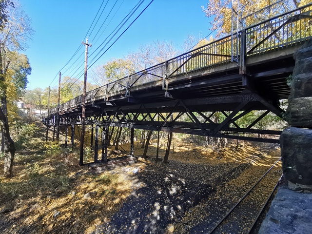
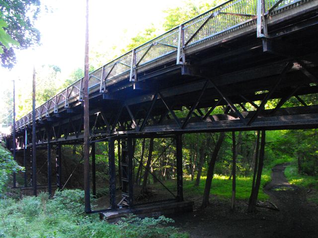
This bridge is a very noteworthy structure for several reasons. First, with a ca. 1894 construction date suggested by the Historic Bridge Inventory, this bridge is an extremely old example of a truss bridge with riveted connections in Pennsylvania. The form of the truss, as a somewhat high level deck truss supported by bents and containing relatively lightweight trusses composed of angles and plate and devoid of the more bulky box beams that often were found on sizable truss bridges. Only the bents contain these heavier box beams.
The railings for this bridge are extremely unusual and they feature a series of closely spaced vertical bars, but behind these bars is what is actually much like a very lightweight Warren pony truss, composed of a series of riveted angles. It is unclear why this truss-like design is used, and if it serves any structural purpose aside from functioning as a railing.
The most unusual feature of this bridge is that it actually has three truss webs, and this third truss web is composed by trusses with a different depth and is supported by bents of a different design too. Further, this third truss is not centered under the bridge, and is instead located next to the downstream truss. Because of this, by all outward appearances, this third truss appears to be an alteration, something added at a date after the bridge was built. It looks like something just stuck in as it could be fit. However the Historic Bridge Inventory suggests this is an original detail and that this third truss was included to provide added support for a part of the bridge which once carried a rail line.
Although this bridge is closed to traffic, and the concrete filled metal grate deck is in very bad condition with severe warping, the metal truss superstructure and substructure could very likely be rehabilitated for light vehicular traffic or pedestrian use. It also appears that there would be room to build a new bridge next to the historic bridge, so the historic bridge could serve pedestrian traffic and the new bridge could serve vehicular traffic. All of these preservation opportunities have been rejected however and this important and unique historic bridge is slated for demolition and replacement, representing a continuation of the widespread demolition of historic metal truss bridges in Pennsylvania, which is occurring without regard to the level of significance a bridge might have.
Information and Findings From Pennsylvania's Historic Bridge InventoryDiscussion of Bridge The 4 span, 292'-long riveted Warren deck truss is simply supported on ashlar abutments and built-up steel bents. The trusses are traditionally composed of angles and plate, and the built up floor beams are placed above the upper chord. Because it was designed to carry streetcars, a shallower truss was placed on the lateral bracing near the downstream truss. The bridge is finished with cantilevered deck sections and metal railings. It was built to carry the Schuylkill Electric Railroad, and it appears on the city directory map in 1895. Prior to 1892 it is depicted as "proposed." The bridge is an early example of riveted field connections, and it is historically and technologically significant. Discussion of Surrounding Area The bridge carries a 2 lane road and sidewalks over the abandoned Schuylkill Canal r-o-w, the Schuylkill River and an abandoned railroad right of way on the northeast side of Pottsville. The road was a link between Pottsville proper and Palo Alto. The road, historically known as Bridge Street, is contemporary with the bridge. The railroad was the Mount Carbon-Port Carbon line that became part of the Reading system. The canal had been abandoned by the time the bridge was erected. Bridge Considered Historic By Survey: Yes |
This bridge is tagged with the following special condition(s): Unorganized Photos
![]()
![]()
![]()
![]()
![]()
Coordinates (Latitude, Longitude):
Search For Additional Bridge Listings:
Bridgehunter.com: View listed bridges within 0.5 miles (0.8 kilometers) of this bridge.
Bridgehunter.com: View listed bridges within 10 miles (16 kilometers) of this bridge.
Additional Maps:
Google Streetview (If Available)
GeoHack (Additional Links and Coordinates)
Apple Maps (Via DuckDuckGo Search)
Apple Maps (Apple devices only)
Android: Open Location In Your Map or GPS App
Flickr Gallery (Find Nearby Photos)
Wikimedia Commons (Find Nearby Photos)
Directions Via Sygic For Android
Directions Via Sygic For iOS and Android Dolphin Browser
USGS National Map (United States Only)
Historical USGS Topo Maps (United States Only)
Historic Aerials (United States Only)
CalTopo Maps (United States Only)

© Copyright 2003-2025, HistoricBridges.org. All Rights Reserved. Disclaimer: HistoricBridges.org is a volunteer group of private citizens. HistoricBridges.org is NOT a government agency, does not represent or work with any governmental agencies, nor is it in any way associated with any government agency or any non-profit organization. While we strive for accuracy in our factual content, HistoricBridges.org offers no guarantee of accuracy. Information is provided "as is" without warranty of any kind, either expressed or implied. Information could include technical inaccuracies or errors of omission. Opinions and commentary are the opinions of the respective HistoricBridges.org member who made them and do not necessarily represent the views of anyone else, including any outside photographers whose images may appear on the page in which the commentary appears. HistoricBridges.org does not bear any responsibility for any consequences resulting from the use of this or any other HistoricBridges.org information. Owners and users of bridges have the responsibility of correctly following all applicable laws, rules, and regulations, regardless of any HistoricBridges.org information.
![]()