

View Information About HSR Ratings
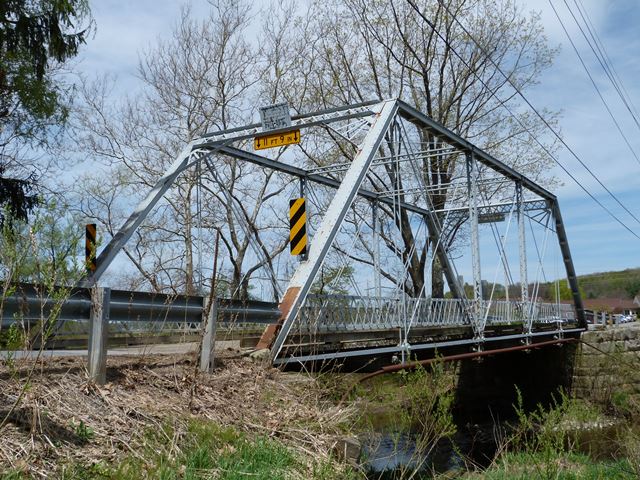
This is a five-panel pin connected Pratt through truss. It features v-lacing on the verticals and sway bracing. The portal bracing is a lattice design. Original lattice railings remain on the bridge. The bridge retains a high degree of historic integrity, with no major alterations to the bridge noted. This bridge is one of a number of Youngstown Bridge Company bridges that remained in Pennsylvania in 2006.
There is no cantilevered sidewalk or handsome railing on this bridge as the Historic Bridge Inventory mentions. They appear to have mixed this bridge up with the Center Street Bridge, since their description is nearly identical to the description of that bridge, which was also built by the same company.
Information and Findings From Pennsylvania's Historic Bridge InventoryDiscussion of Bridge The 1896, pin connected, single span, 80'-long, Pratt thru truss bridge is supported on ashlar abutments. Fabricated by the Youngstown Bridge Co., the bridge stands as a remarkably complete example of its type and design with its decorative cresting and handsome cast and wrought iron railing at the cantilevered sidewalk. The trusses themselves are traditionally composed, but the lattice filled portal brace and knee braces with radiation pattern fill are characteristic of the fabricator. The bridge stands out in a rich collection of metal truss bridges in Crawford County, and it is historically and technologically significant. Discussion of Surrounding Area The bridge carries 1 lane of a 2 lane road over a stream south of the borough of Saegertown. The area does not have historic district potential. Approximately one-half mile to the north is the county poor farm complex. The original building dates to ca. 1875, and many later buildings have been added. The complex was greatly expanded in 1970s and 1980s. The bridge is not contiguous to the complex or related to its function. South of the bridge is wooded and rural. Bridge Considered Historic By Survey: Yes |
![]()
![]()
![]()
Coordinates (Latitude, Longitude):
Search For Additional Bridge Listings:
Bridgehunter.com: View listed bridges within 0.5 miles (0.8 kilometers) of this bridge.
Bridgehunter.com: View listed bridges within 10 miles (16 kilometers) of this bridge.
Additional Maps:
Google Streetview (If Available)
GeoHack (Additional Links and Coordinates)
Apple Maps (Via DuckDuckGo Search)
Apple Maps (Apple devices only)
Android: Open Location In Your Map or GPS App
Flickr Gallery (Find Nearby Photos)
Wikimedia Commons (Find Nearby Photos)
Directions Via Sygic For Android
Directions Via Sygic For iOS and Android Dolphin Browser
USGS National Map (United States Only)
Historical USGS Topo Maps (United States Only)
Historic Aerials (United States Only)
CalTopo Maps (United States Only)

© Copyright 2003-2025, HistoricBridges.org. All Rights Reserved. Disclaimer: HistoricBridges.org is a volunteer group of private citizens. HistoricBridges.org is NOT a government agency, does not represent or work with any governmental agencies, nor is it in any way associated with any government agency or any non-profit organization. While we strive for accuracy in our factual content, HistoricBridges.org offers no guarantee of accuracy. Information is provided "as is" without warranty of any kind, either expressed or implied. Information could include technical inaccuracies or errors of omission. Opinions and commentary are the opinions of the respective HistoricBridges.org member who made them and do not necessarily represent the views of anyone else, including any outside photographers whose images may appear on the page in which the commentary appears. HistoricBridges.org does not bear any responsibility for any consequences resulting from the use of this or any other HistoricBridges.org information. Owners and users of bridges have the responsibility of correctly following all applicable laws, rules, and regulations, regardless of any HistoricBridges.org information.
![]()