

View Information About HSR Ratings
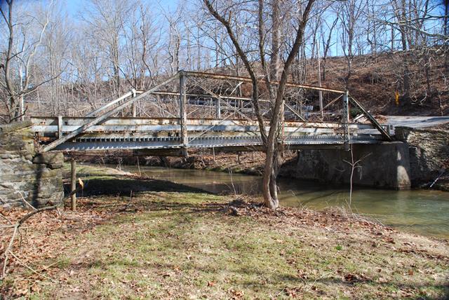
This classic Wrought Iron Bridge Company pony truss bridge is located on a private driveway next to a public road. The bridge itself apparently is or was owned by the county as it had an entry in Pennsylvania's Historic Bridge Inventory and a BMS Number as well.
Information and Findings From Pennsylvania's Historic Bridge InventoryDiscussion of Bridge The single span, 64'-long, metal Pratt pony truss bridge built in 1890 is supported on stone abutments. The truss is composed of built-up compression members and eye bar and rod tension members. It has pin connections with the exception of cast iron connecting pieces at the upper chord-end post connections, a detail associated with Wrought Iron Bridge Co. pony truss bridges. U-shaped hangers support rolled section floorbeams carrying steel stringers and an open steel grid deck placed ca. 1980. Original railings have been lost and replaced by welded channel railings. The bridge is a historically and technologically significant example of its type/design by an important late 19th century fabricator. The Wrought Iron Bridge Co. of Canton, OH, was among the best known and most successful bridge fabricators to establish a national market for its bridges. The company was very active in York County during the last two decades of the 19th century. Discussion of Surrounding Area The bridge carries a 1 lane road over a stream in a rural setting with active farms and scattered 19th to late 20th century residences. A late 19th century vernacular farm residence is located at the northwest quadrant. The setting does not have the cohesiveness or integrity of a historic district. Bridge Considered Historic By Survey: Yes |
![]()
![]()
![]()
This bridge is on private property but is viewable from the adjacent public road.
Coordinates (Latitude, Longitude):
Search For Additional Bridge Listings:
Bridgehunter.com: View listed bridges within 0.5 miles (0.8 kilometers) of this bridge.
Bridgehunter.com: View listed bridges within 10 miles (16 kilometers) of this bridge.
Additional Maps:
Google Streetview (If Available)
GeoHack (Additional Links and Coordinates)
Apple Maps (Via DuckDuckGo Search)
Apple Maps (Apple devices only)
Android: Open Location In Your Map or GPS App
Flickr Gallery (Find Nearby Photos)
Wikimedia Commons (Find Nearby Photos)
Directions Via Sygic For Android
Directions Via Sygic For iOS and Android Dolphin Browser
USGS National Map (United States Only)
Historical USGS Topo Maps (United States Only)
Historic Aerials (United States Only)
CalTopo Maps (United States Only)

© Copyright 2003-2025, HistoricBridges.org. All Rights Reserved. Disclaimer: HistoricBridges.org is a volunteer group of private citizens. HistoricBridges.org is NOT a government agency, does not represent or work with any governmental agencies, nor is it in any way associated with any government agency or any non-profit organization. While we strive for accuracy in our factual content, HistoricBridges.org offers no guarantee of accuracy. Information is provided "as is" without warranty of any kind, either expressed or implied. Information could include technical inaccuracies or errors of omission. Opinions and commentary are the opinions of the respective HistoricBridges.org member who made them and do not necessarily represent the views of anyone else, including any outside photographers whose images may appear on the page in which the commentary appears. HistoricBridges.org does not bear any responsibility for any consequences resulting from the use of this or any other HistoricBridges.org information. Owners and users of bridges have the responsibility of correctly following all applicable laws, rules, and regulations, regardless of any HistoricBridges.org information.
![]()