

View Information About HSR Ratings
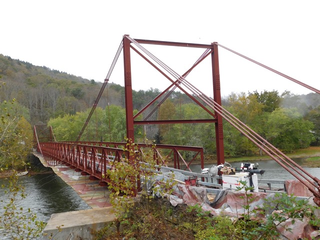
Although most of the bridge seen today actually dates to 1936, this small scale suspension bridge is noted for its unusual design which features a main cable that dips below the deck of the bridge. HistoricBridges.org is hestitant to list this as an 1889 bridge given that nearly all material seen on the bridge today dates to 1936. In either case, even if considered a 1936 bridge, its design is unique and it stands out on the collection of historic bridges on the Delaware River as a result. The bridge is posted for 8' height and 11 Ton weight limit after the latest rehab.
The 1889 bridge actually had timber stiffening trusses rather than the steel seen today.
Additional rehab was taking place when these photos were taken.
Marc Scotti provides the following area railroad history (in reference to the railroad line that is a few feet from this bridge)
The railroad in the picture is the Southern Tier Line across New York State (the same line that crosses the famous trestle (now an arch bridge) in Letchworth Park in western New York). I believe it was originally a way for NYS To give something to the communities across the southern tier of the state, because the Erie Canal went across the northern portion.|
It was originally the Erie Railroad (New York Lake Erie, & Western). Portions of the Delaware, Lackawanna, and Western ran right next to it west of Binghamton. Eventually the parallel lines could not both be sustained, so they merged to become the Erie-Lackawanna. Hurricane Agnes in 1972 destroyed large sections of the line, and the E-L soon went bankrupt. So then the line was offered to the Chessie system (now part of CSX) by the government to provide token competition to the government creation called Conrail, which merged six other bankrupt railroads in 1976.
Conrail didn't care about the line, because they were also given both the New York Central and Pennsylvania main lines, which ran parallel to this line. Conrail ran a token train or two, but never did anything more than to prevent someone else from owning it and competing with them. The Susquehanna also had trackage rights to connect their divisions in NJ and NY.
Once the feds put Conrail up for sale, CSX & Norfolk Southern carved it up, with Norfolk Southern getting this line and the Pennsylvania main line. So again, the line's owner had a much more important route nearby. So they don't run anything east of Binghamton, and leased that portion out to the Central New York Railroad who still has the New York, Susquehanna and Western Railway run a train or two a day over it to connect their lines in NY and NJ. The Susquehanna and the Central New York Railroad are both part of Delaware-Otsego Corp., which was split up 40% CSX-40% NS-20% to the owner (Walter Rich) as a bribe to get NYS to approve the Conrail transaction while keeping the Susquehanna from being completely cut out after their piggyback traffic to north jersey would be taken by the big boys.
So, the actual engines you'll see are the Susquehanna's yellow-jackets. But when they need more power, they lease an engine or two from each of their owners, and I actually saw all three coupled together once.
This bridge is tagged with the following special condition(s): Unorganized Photos
![]()
![]()
![]()
Coordinates (Latitude, Longitude):
Search For Additional Bridge Listings:
Bridgehunter.com: View listed bridges within 0.5 miles (0.8 kilometers) of this bridge.
Bridgehunter.com: View listed bridges within 10 miles (16 kilometers) of this bridge.
Additional Maps:
Google Streetview (If Available)
GeoHack (Additional Links and Coordinates)
Apple Maps (Via DuckDuckGo Search)
Apple Maps (Apple devices only)
Android: Open Location In Your Map or GPS App
Flickr Gallery (Find Nearby Photos)
Wikimedia Commons (Find Nearby Photos)
Directions Via Sygic For Android
Directions Via Sygic For iOS and Android Dolphin Browser
USGS National Map (United States Only)
Historical USGS Topo Maps (United States Only)
Historic Aerials (United States Only)
CalTopo Maps (United States Only)

© Copyright 2003-2025, HistoricBridges.org. All Rights Reserved. Disclaimer: HistoricBridges.org is a volunteer group of private citizens. HistoricBridges.org is NOT a government agency, does not represent or work with any governmental agencies, nor is it in any way associated with any government agency or any non-profit organization. While we strive for accuracy in our factual content, HistoricBridges.org offers no guarantee of accuracy. Information is provided "as is" without warranty of any kind, either expressed or implied. Information could include technical inaccuracies or errors of omission. Opinions and commentary are the opinions of the respective HistoricBridges.org member who made them and do not necessarily represent the views of anyone else, including any outside photographers whose images may appear on the page in which the commentary appears. HistoricBridges.org does not bear any responsibility for any consequences resulting from the use of this or any other HistoricBridges.org information. Owners and users of bridges have the responsibility of correctly following all applicable laws, rules, and regulations, regardless of any HistoricBridges.org information.
![]()