

View Information About HSR Ratings

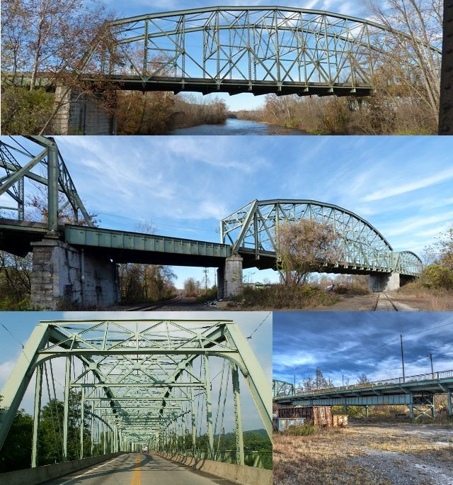
The is New Castle's stunning landmark bridge. With a total length similar to a bridge over a major river, this structure gets its length from a combined railroad-river crossing. It crosses extensive railroad trackage. The center span of this bridge features a bizarre skew like that seen more clearly on the Mill Street Bridge. According to the mill marks on the bridge, the steel on this bridge was fabricated by Bethlehem Steel. There is both lattice and v-lacing present on many areas of the bridge's built-up beams. This bridge is interesting because it is a curved bridge, meaning the road actually curves on the bridge, and as such the truss spans are not lined up in a straight row. This is a spectacular bridge, and a joy to drive across. With the demolition of the aforementioned Mill Street Bridge and other Thomas Gilkey bridges in the county, this large bridge is a last remaining example of the design work by a local engineer who stuck to traditional methods of pin-connected truss bridges far longer than most engineers did. The finding of the Historic Bridge Inventory that this bridge is not historic should be overturned because of the demolition of other Gilkey bridges and also because of the bridge's significance as a substantial engineering achievement by a local engineer.
I didn't get a chance to try for a side view or under-deck view of this bridge. From the sounds of its description, with deck plate girder approaches and "steel bents" for support, the underside of this bridge is likely to be interesting. The steel bents may be v-laced or latticed.
From the deck of this bridge you can view a magnificently beautiful railroad bridge, the P&LE Big Run Branch Railroad Bridge.
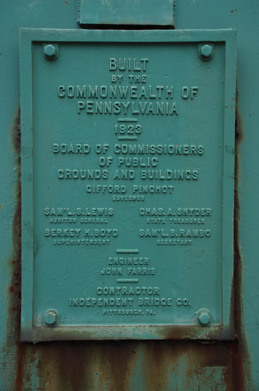
Above: Brian McKee visited the bridge in April 2009 and submitted this plaque photo to Bridgehunter.com however it appears to have since been stolen.
Information and Findings From Pennsylvania's Historic Bridge InventoryDiscussion of Bridge The 11-span, 1,195'-long, Mahoning Avenue Viaduct built in 1923 consists of 3, pin-connected, Pennsylvania truss main spans of 307', 306', and 227' lengths and 8 built up deck girder approach spans. The substructure consists of concrete abutments and piers with the approaches supported on steel bents on concrete pads. The cantilevered sidewalk is finished with a period metal railing. The bridge was built for the county and the state, and it was designed by Thomas Gilkey who did a great deal of bridge design work for Lawrence County. As a design preference, Mr. Gilkey used pinned connections for his truss bridges through the 1920s. The bridge is a late example of its type and technology, and it is not historically or technologically significant. Discussion of Surrounding Area The viaduct carries a two-lane city street and a sidewalk over the Shenango River and numerous trackage associated with the Pittsburgh & Lake Erie Railroad, CSXT (formerly the B&O Railroad), and Conrail (formerly the Erie Railroad) in the vicinity of the Pennsylvania Railroad's New Castle Junction and the B & O's New Castle Junction and their New Castle yard. It is in New Castle. Most of the rail yard has been removed as what appears to have been a steel or iron mill beyond the west side of the bridge. The setting does not have integrity. Bridge Considered Historic By Survey: No |
![]()
![]()
![]()
Coordinates (Latitude, Longitude):
Search For Additional Bridge Listings:
Bridgehunter.com: View listed bridges within 0.5 miles (0.8 kilometers) of this bridge.
Bridgehunter.com: View listed bridges within 10 miles (16 kilometers) of this bridge.
Additional Maps:
Google Streetview (If Available)
GeoHack (Additional Links and Coordinates)
Apple Maps (Via DuckDuckGo Search)
Apple Maps (Apple devices only)
Android: Open Location In Your Map or GPS App
Flickr Gallery (Find Nearby Photos)
Wikimedia Commons (Find Nearby Photos)
Directions Via Sygic For Android
Directions Via Sygic For iOS and Android Dolphin Browser
USGS National Map (United States Only)
Historical USGS Topo Maps (United States Only)
Historic Aerials (United States Only)
CalTopo Maps (United States Only)

© Copyright 2003-2025, HistoricBridges.org. All Rights Reserved. Disclaimer: HistoricBridges.org is a volunteer group of private citizens. HistoricBridges.org is NOT a government agency, does not represent or work with any governmental agencies, nor is it in any way associated with any government agency or any non-profit organization. While we strive for accuracy in our factual content, HistoricBridges.org offers no guarantee of accuracy. Information is provided "as is" without warranty of any kind, either expressed or implied. Information could include technical inaccuracies or errors of omission. Opinions and commentary are the opinions of the respective HistoricBridges.org member who made them and do not necessarily represent the views of anyone else, including any outside photographers whose images may appear on the page in which the commentary appears. HistoricBridges.org does not bear any responsibility for any consequences resulting from the use of this or any other HistoricBridges.org information. Owners and users of bridges have the responsibility of correctly following all applicable laws, rules, and regulations, regardless of any HistoricBridges.org information.
![]()