

View Information About HSR Ratings
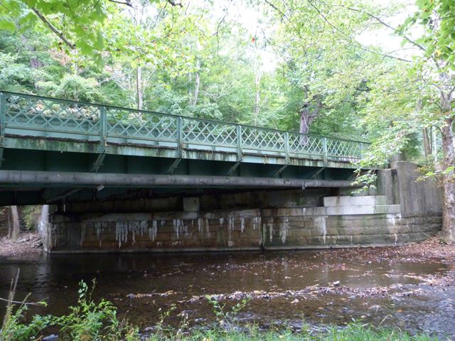
This was a state standard highway plate girder with sidewalk and lattice railing.
Information and Findings From Pennsylvania's Historic Bridge InventoryDiscussion of Bridge The 1935, skewed, single span, built up thru girder bridge is supported on ashlar abutments with wingwalls that date from an earlier bridge. The substructure has been reinforced and also raised with concrete. The girder bridge has steel I beam floorbeams and a concrete deck. The sidewalk is cantilevered off the bridge's south side using steel brackets. The lattice railing is original. The bridge is an example of a common type with no innovative or distinguishing detail. Thru girder bridges were first developed by the railroad industry in the 1850s, and they were used on vehicular roadways beginning in the late 19th century. Neither the bridge nor its setting and context are historically or technologically noteworthy. Discussion of Surrounding Area The bridge carries a 2 lane and 1 sidewalk road over a stream in a rural area of active farms. Bridge Considered Historic By Survey: No |
This bridge is tagged with the following special condition(s): Unorganized Photos
![]()
![]()
![]()
This historic bridge has been demolished. This map is shown for reference purposes only.
Coordinates (Latitude, Longitude):
Search For Additional Bridge Listings:
Bridgehunter.com: View listed bridges within 0.5 miles (0.8 kilometers) of this bridge.
Bridgehunter.com: View listed bridges within 10 miles (16 kilometers) of this bridge.
Additional Maps:
Google Streetview (If Available)
GeoHack (Additional Links and Coordinates)
Apple Maps (Via DuckDuckGo Search)
Apple Maps (Apple devices only)
Android: Open Location In Your Map or GPS App
Flickr Gallery (Find Nearby Photos)
Wikimedia Commons (Find Nearby Photos)
Directions Via Sygic For Android
Directions Via Sygic For iOS and Android Dolphin Browser
USGS National Map (United States Only)
Historical USGS Topo Maps (United States Only)
Historic Aerials (United States Only)
CalTopo Maps (United States Only)

© Copyright 2003-2025, HistoricBridges.org. All Rights Reserved. Disclaimer: HistoricBridges.org is a volunteer group of private citizens. HistoricBridges.org is NOT a government agency, does not represent or work with any governmental agencies, nor is it in any way associated with any government agency or any non-profit organization. While we strive for accuracy in our factual content, HistoricBridges.org offers no guarantee of accuracy. Information is provided "as is" without warranty of any kind, either expressed or implied. Information could include technical inaccuracies or errors of omission. Opinions and commentary are the opinions of the respective HistoricBridges.org member who made them and do not necessarily represent the views of anyone else, including any outside photographers whose images may appear on the page in which the commentary appears. HistoricBridges.org does not bear any responsibility for any consequences resulting from the use of this or any other HistoricBridges.org information. Owners and users of bridges have the responsibility of correctly following all applicable laws, rules, and regulations, regardless of any HistoricBridges.org information.
![]()