We Recommend:
Bach Steel - Experts at historic truss bridge restoration.
BridgeHunter.com Phase 1 is released to the public! - Visit Now
Ridge Avenue Bridge

Primary Photographer(s): Nathan Holth and Rick McOmber
Bridge Documented: August 2, 2007, July 16, 2011, and June 27, 2021
Pittsburgh: Allegheny County, Pennsylvania: United States
1903 By Builder/Contractor: Fort Pitt Bridge Works of Pittsburgh, Pennsylvania
1957
65.0 Feet (19.8 Meters)
68.0 Feet (20.7 Meters)
40.4 Feet (12.31 Meters)
1 Main Span(s)
27301000030810

View Information About HSR Ratings
Bridge Documentation
This bridge's future is at risk!
Bridge Status: This historic bridge is slated for demolition with no replacement planned!View Archived National Bridge Inventory Report - Has Additional Details and Evaluation
View The Determination of Effects Report For This Historic Bridge Demolition Project
This bridge is nearby and of the same design as the Ohio Street Bridge. Both are slated for demolition.
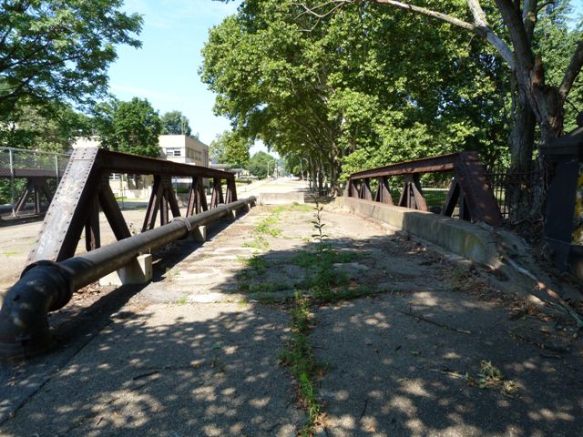
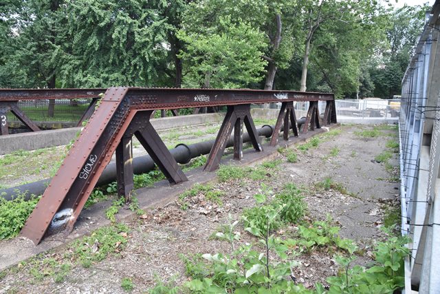
The Pennsylvania Historic Bridge Inventory listed the bridge as historic because it is part of a historic railroad line. However, the bridge should be considered individually significant because of its uncommon design, which features bulky girders supporting the sidewalk, and due to its wide, three truss design, all of this presented in a structure that retains good historic integrity. The bridge is also unusual because the bottom chord is designed like a plate girder, which the trusses are built into. In other words, there is no distinction between a gusset plate for the riveted connections and the bottom chord... both are the same piece of steel. The bridge also features attractive pedestrian railings, and is an attractive addition to a bridge on a road that travels through a park setting.
This bridge was not maintained over the years and section loss was allowed to spread and deepen both on the sidewalk girders and at the base of the truss members near the deck. As of 2012, extensive areas of complete section loss were identified on the bridge in these areas. Section loss is a process where metal is completely removed from a metal bridge as the metal converts to rust. Eventually it leaves holes in the bridge. Section loss is a 100% preventable problem. A bridge could be 1000 years old and have zero section loss. How? Simply keep rust from forming by keeping the paint system on the bridge in good condition. A simple coat of paint is all it would have taken to keep this bridge from deteriorating. The owner of this bridge failed to do so and as a result, tax dollars will now be wasted in a costly demolition project that will destroy this historic bridge and damage the heritage of the park and historic railroad line.
Information and Findings From Pennsylvania's Historic Bridge InventoryDiscussion of Bridge The single span, 68'-long, rivet connected Warren with verticals pony truss bridge built in 1903 has three truss lines with the middle one dividing the roadway. The lower chords are composed of built-up plate and angles resembling a girder, an unusual detail. The bridge is supported on ashlar abutments that are contiguous with the rail line's retaining walls. In 1957, welded cover plate was added to the lower chord and panel points. The bridge was designed by the Pennsylvania Railroad and fabricated by the Fort Pitt Bridge Works. the bridge is not individually significant, but it is historically significant in association with the PHMC-determined eligible PRR Fort Wayne Division line. The bridge dates from the line's period of significance and was built during a period when the railroad was actively improving the line for higher speeds and capacity, which included quadruple tracking and grade crossing improvements. Discussion of Surrounding Area The bridge carries a 2 lane street and 1 sidewalk over 3 active Conrail tracks in Pittsburgh's near North Side in Allegheny Commons Park. One block from the bridge is another similar bridge over the same line (BMS# 02730100003118). The railroad is the former PRR Fort Wayne Division line that has been determined eligible by PHMC (DOE 9/14/93). This section of the line was established in the 1850s, and it has historically provided a vital transportation link in the flow of east-west traffic on the PRR system. It was the main route westward from Pittsburgh to Chicago with branches to Detroit, Cleveland, and Toledo. Bridge Considered Historic By Survey: Yes |
This bridge is tagged with the following special condition(s): Unorganized Photos
![]()
Photo Galleries and Videos: Ridge Avenue Bridge
2011 Bridge Photo-Documentation
Original / Full Size PhotosA collection of overview and detail photos, taken in 2011. This gallery offers photos in the highest available resolution and file size in a touch-friendly popup viewer.
Alternatively, Browse Without Using Viewer
![]()
2011 Bridge Photo-Documentation
Mobile Optimized PhotosA collection of overview and detail photos, taken in 2011. This gallery features data-friendly, fast-loading photos in a touch-friendly popup viewer.
Alternatively, Browse Without Using Viewer
![]()
2007 Bridge Photo-Documentation
A collection of overview and detail photos, taken in 2007. This photo gallery contains a combination of Original Size photos and Mobile Optimized photos in a touch-friendly popup viewer.Alternatively, Browse Without Using Viewer
![]()
2021 Additional Unorganized Photos
Original / Full Size PhotosA supplemental collection of photos that are from additional visit(s) to the bridge and have not been organized or captioned. This gallery offers photos in the highest available resolution and file size in a touch-friendly popup viewer.
Alternatively, Browse Without Using Viewer
![]()
2021 Additional Unorganized Photos
Mobile Optimized PhotosA supplemental collection of photos that are from additional visit(s) to the bridge and have not been organized or captioned. This gallery features data-friendly, fast-loading photos in a touch-friendly popup viewer.
Alternatively, Browse Without Using Viewer
![]()
Maps and Links: Ridge Avenue Bridge
Coordinates (Latitude, Longitude):
Search For Additional Bridge Listings:
Bridgehunter.com: View listed bridges within 0.5 miles (0.8 kilometers) of this bridge.
Bridgehunter.com: View listed bridges within 10 miles (16 kilometers) of this bridge.
Additional Maps:
Google Streetview (If Available)
GeoHack (Additional Links and Coordinates)
Apple Maps (Via DuckDuckGo Search)
Apple Maps (Apple devices only)
Android: Open Location In Your Map or GPS App
Flickr Gallery (Find Nearby Photos)
Wikimedia Commons (Find Nearby Photos)
Directions Via Sygic For Android
Directions Via Sygic For iOS and Android Dolphin Browser
USGS National Map (United States Only)
Historical USGS Topo Maps (United States Only)
Historic Aerials (United States Only)
CalTopo Maps (United States Only)


