

View Information About HSR Ratings
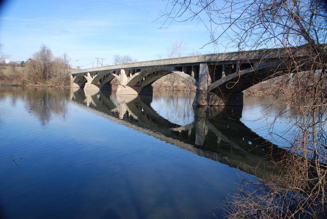
This bridge is an attractive open spandrel concrete arch bridge. The top portion of the bridge: floor beams, deck, and railing have all been replaced. The railings are modern New Jersey Barriers... not remotely similar to the original bridge. So, while the bridge today remains an attractive and historically significant example of a somewhat early surviving arch bridge, the only people who can enjoy the historic aspects of the bridge are those beside the bridge. To people crossing the bridge, there is nothing historic to see anymore and the bridge looks modern. Recommended future preservation work for this bridge would be to replace the New Jersey barriers with replicas of the original railings. If needed, the exact dimensions and reinforcing could be altered to ensure the railings meet safety standards. Such techniques have been employed successfully in preservation projects elsewhere in the country.
Information and Findings From Pennsylvania's Historic Bridge InventoryDiscussion of Bridge The 5 span, 554'-long open spandrel arch bridge is listed in the National Register. In 1991 the bridge's concrete floorbeams, deck, parapets, and concrete light standards were removed. A wider deck was added; the railings were replaced with concrete parapets with paneled exterior faces and safety shape interior faces. Discussion of Surrounding Area The bridge carries a 2 lane highway over the Schuylkill River between Chester and Montgomery counties. The setting is rural with scattered mid- to late-20th century residences. Bridge Considered Historic By Survey: Yes |
![]()
![]()
![]()
Coordinates (Latitude, Longitude):
Search For Additional Bridge Listings:
Bridgehunter.com: View listed bridges within 0.5 miles (0.8 kilometers) of this bridge.
Bridgehunter.com: View listed bridges within 10 miles (16 kilometers) of this bridge.
Additional Maps:
Google Streetview (If Available)
GeoHack (Additional Links and Coordinates)
Apple Maps (Via DuckDuckGo Search)
Apple Maps (Apple devices only)
Android: Open Location In Your Map or GPS App
Flickr Gallery (Find Nearby Photos)
Wikimedia Commons (Find Nearby Photos)
Directions Via Sygic For Android
Directions Via Sygic For iOS and Android Dolphin Browser
USGS National Map (United States Only)
Historical USGS Topo Maps (United States Only)
Historic Aerials (United States Only)
CalTopo Maps (United States Only)

© Copyright 2003-2025, HistoricBridges.org. All Rights Reserved. Disclaimer: HistoricBridges.org is a volunteer group of private citizens. HistoricBridges.org is NOT a government agency, does not represent or work with any governmental agencies, nor is it in any way associated with any government agency or any non-profit organization. While we strive for accuracy in our factual content, HistoricBridges.org offers no guarantee of accuracy. Information is provided "as is" without warranty of any kind, either expressed or implied. Information could include technical inaccuracies or errors of omission. Opinions and commentary are the opinions of the respective HistoricBridges.org member who made them and do not necessarily represent the views of anyone else, including any outside photographers whose images may appear on the page in which the commentary appears. HistoricBridges.org does not bear any responsibility for any consequences resulting from the use of this or any other HistoricBridges.org information. Owners and users of bridges have the responsibility of correctly following all applicable laws, rules, and regulations, regardless of any HistoricBridges.org information.
![]()