

View Information About HSR Ratings
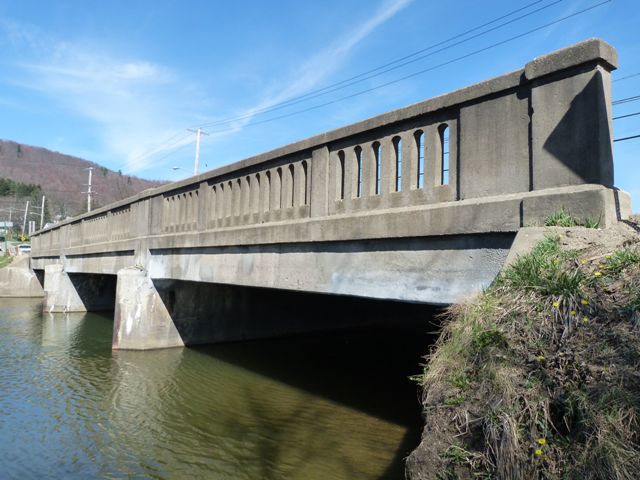
This bridge is a t-beam that was originally built in 1921. In 1946 it was widened. The technology of the t-beam really would not have changed between these years, and the widening required replacement of the original railings. As such, despite the fact that the bridge has some 1921 beams, the bridge would be better evaluated as a 1946 t-beam bridge. As such, this bridge can be said to be a representative example of a typical 1940s t-beam bridge in Pennsylvania. The bridge displays state standard balustrade railings. Pennsylvania had a number of state standard railing designs. Among the balustrade railings like that seen on this bridge, there seems to have two different railing heights. This bridge displays the taller railing design.
Information and Findings From Pennsylvania's Historic Bridge InventoryDiscussion of Bridge The 3 span, 100'-long, T beam bridge, built in 1921 and widened in kind on both sides in 1946, is supported on reinforced concrete piers and abutments with wingwalls. It is finished with standard concrete balustrades on each side of the concrete deck. It is one of over 2351. Discussion of Surrounding Area The bridge carries US 6, a 2 lane federal highway, over a stream in the borough of Smethport, a rural town dominated by a mix of 20th century residential and commercial structures. The borough does not appear to have historic district potential. Bridge Considered Historic By Survey: No |
![]()
![]()
![]()
This historic bridge has been demolished. This map is shown for reference purposes only.
Coordinates (Latitude, Longitude):
Search For Additional Bridge Listings:
Bridgehunter.com: View listed bridges within 0.5 miles (0.8 kilometers) of this bridge.
Bridgehunter.com: View listed bridges within 10 miles (16 kilometers) of this bridge.
Additional Maps:
Google Streetview (If Available)
GeoHack (Additional Links and Coordinates)
Apple Maps (Via DuckDuckGo Search)
Apple Maps (Apple devices only)
Android: Open Location In Your Map or GPS App
Flickr Gallery (Find Nearby Photos)
Wikimedia Commons (Find Nearby Photos)
Directions Via Sygic For Android
Directions Via Sygic For iOS and Android Dolphin Browser
USGS National Map (United States Only)
Historical USGS Topo Maps (United States Only)
Historic Aerials (United States Only)
CalTopo Maps (United States Only)

© Copyright 2003-2025, HistoricBridges.org. All Rights Reserved. Disclaimer: HistoricBridges.org is a volunteer group of private citizens. HistoricBridges.org is NOT a government agency, does not represent or work with any governmental agencies, nor is it in any way associated with any government agency or any non-profit organization. While we strive for accuracy in our factual content, HistoricBridges.org offers no guarantee of accuracy. Information is provided "as is" without warranty of any kind, either expressed or implied. Information could include technical inaccuracies or errors of omission. Opinions and commentary are the opinions of the respective HistoricBridges.org member who made them and do not necessarily represent the views of anyone else, including any outside photographers whose images may appear on the page in which the commentary appears. HistoricBridges.org does not bear any responsibility for any consequences resulting from the use of this or any other HistoricBridges.org information. Owners and users of bridges have the responsibility of correctly following all applicable laws, rules, and regulations, regardless of any HistoricBridges.org information.
![]()