

View Information About HSR Ratings
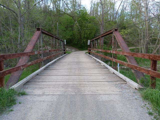
Although the Historic Bridge Inventory thought this bridge might have been built by the Groton Bridge Company, it is clearly the product of the Penn Bridge Company. It has the unusual detail of two pins at the ends of the top chord, one for the diagonal member, and one for the vertical member. Also, the hanger detail where it connects to the vertical member via a single bolt and nut is an unusual detail. This detail appears on other Penn Bridge Company bridges from the 1880s. The National Bridge Inventory construction date of 1912 may refer to a relocation of this bridge, and/or reconstruction of the abutments as concrete. Timber bents have been added to bear the load, rendering the trusses somewhat decorative in function today.
Information and Findings From Pennsylvania's Historic Bridge InventoryDiscussion of Bridge The single-span, 68'-long, pin-connected Pratt pony truss bridge is supported on stone abutments. It dates stylistically to ca. 1895, and has details that suggest it may have been fabricated by the Groton Bridge Co. The trusses are traditionally composed, and there are two unusual details. Two pins are used at the upper hip panel point, and the back-to-back angles of the verticals flare to accommodate a rivet-connected triangular-shaped pin plate for the lower panel points. The floor beams are built up. The bridge is remarkably complete, and it represents the experimentation in design that of the early days of metal truss bridges. The span is historically and technologically significant. A wood helper bent has been added at an unknown date. Discussion of Surrounding Area The bridge carries a one lane of an unimproved road over a stream in a sparsely developed, wooded setting with scattered residential development. Bridge Considered Historic By Survey: Yes |
![]()
![]()
![]()
This historic bridge has been demolished. This map is shown for reference purposes only.
Coordinates (Latitude, Longitude):
Search For Additional Bridge Listings:
Bridgehunter.com: View listed bridges within 0.5 miles (0.8 kilometers) of this bridge.
Bridgehunter.com: View listed bridges within 10 miles (16 kilometers) of this bridge.
Additional Maps:
Google Streetview (If Available)
GeoHack (Additional Links and Coordinates)
Apple Maps (Via DuckDuckGo Search)
Apple Maps (Apple devices only)
Android: Open Location In Your Map or GPS App
Flickr Gallery (Find Nearby Photos)
Wikimedia Commons (Find Nearby Photos)
Directions Via Sygic For Android
Directions Via Sygic For iOS and Android Dolphin Browser
USGS National Map (United States Only)
Historical USGS Topo Maps (United States Only)
Historic Aerials (United States Only)
CalTopo Maps (United States Only)

© Copyright 2003-2025, HistoricBridges.org. All Rights Reserved. Disclaimer: HistoricBridges.org is a volunteer group of private citizens. HistoricBridges.org is NOT a government agency, does not represent or work with any governmental agencies, nor is it in any way associated with any government agency or any non-profit organization. While we strive for accuracy in our factual content, HistoricBridges.org offers no guarantee of accuracy. Information is provided "as is" without warranty of any kind, either expressed or implied. Information could include technical inaccuracies or errors of omission. Opinions and commentary are the opinions of the respective HistoricBridges.org member who made them and do not necessarily represent the views of anyone else, including any outside photographers whose images may appear on the page in which the commentary appears. HistoricBridges.org does not bear any responsibility for any consequences resulting from the use of this or any other HistoricBridges.org information. Owners and users of bridges have the responsibility of correctly following all applicable laws, rules, and regulations, regardless of any HistoricBridges.org information.
![]()