

View Information About HSR Ratings
This bridge is one of an unusually large number of historic bridges found on Nescopeck Creek. In particular, this bridge is the center of a trio of historic truss bridges that are located unusually close to each other. All three bridges serve north-south roads and each road is less than a quarter mile away from the next nearest road. It is not known why so three bridges were needed here. Indeed the redundancy seems to have been confirmed by the fact that the Kellers Road Bridge is now abandoned.
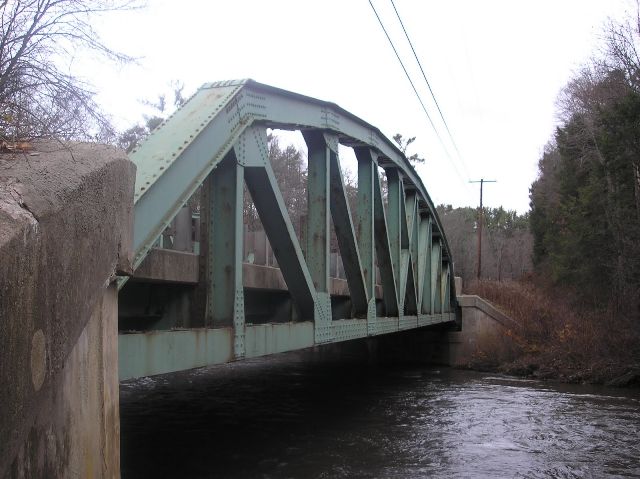
This bridge is a good representative example of a state standard plan pony truss bridge in Pennsylvania.
Information and Findings From Pennsylvania's Historic Bridge InventoryDiscussion of Bridge The single span, 132'-long steel rivet-connected Parker pony truss bridge built in 1936 is supported on concrete abutments with flared wingwalls. The truss members are built-up top and bottom chord sections, with rolled I beam sections used for the verticals and diagonals. Rolled floorbeams and stringers support a concrete deck. The original railings were replaced with W-beam guide rails when the deck was replaced in 1986. The bridge is an example of a state highway department standard design rivet-connected truss bridge that was used with great frequency beginning in the mid 1920s. It has no innovative or distinctive details. Approximately 75 riveted Parker truss highway bridges built between 1925 and 1957 have been identified. Neither the bridge nor its setting is historically or technologically significant. Discussion of Surrounding Area The bridge carries a 2 lane state highway with shoulders over a stream in a sparsely developed, forested setting. The setting does not appear to have historic district potential. Bridge Considered Historic By Survey: No |
![]()
![]()
![]()
Coordinates (Latitude, Longitude):
Search For Additional Bridge Listings:
Bridgehunter.com: View listed bridges within 0.5 miles (0.8 kilometers) of this bridge.
Bridgehunter.com: View listed bridges within 10 miles (16 kilometers) of this bridge.
Additional Maps:
Google Streetview (If Available)
GeoHack (Additional Links and Coordinates)
Apple Maps (Via DuckDuckGo Search)
Apple Maps (Apple devices only)
Android: Open Location In Your Map or GPS App
Flickr Gallery (Find Nearby Photos)
Wikimedia Commons (Find Nearby Photos)
Directions Via Sygic For Android
Directions Via Sygic For iOS and Android Dolphin Browser
USGS National Map (United States Only)
Historical USGS Topo Maps (United States Only)
Historic Aerials (United States Only)
CalTopo Maps (United States Only)

© Copyright 2003-2025, HistoricBridges.org. All Rights Reserved. Disclaimer: HistoricBridges.org is a volunteer group of private citizens. HistoricBridges.org is NOT a government agency, does not represent or work with any governmental agencies, nor is it in any way associated with any government agency or any non-profit organization. While we strive for accuracy in our factual content, HistoricBridges.org offers no guarantee of accuracy. Information is provided "as is" without warranty of any kind, either expressed or implied. Information could include technical inaccuracies or errors of omission. Opinions and commentary are the opinions of the respective HistoricBridges.org member who made them and do not necessarily represent the views of anyone else, including any outside photographers whose images may appear on the page in which the commentary appears. HistoricBridges.org does not bear any responsibility for any consequences resulting from the use of this or any other HistoricBridges.org information. Owners and users of bridges have the responsibility of correctly following all applicable laws, rules, and regulations, regardless of any HistoricBridges.org information.
![]()