

View Information About HSR Ratings
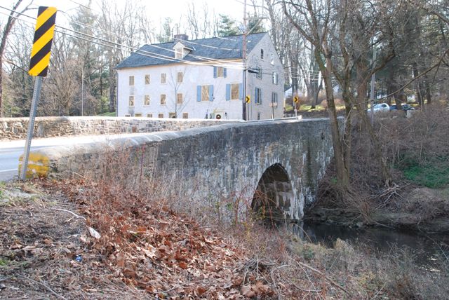
This bridge contributes to a potential historic district, which means that the bridge and surrounding setting is like a trip back in time. The only shortcoming that the bridge has is one side was covered in concrete and looks like a concrete arch now. However the other side was not altered, and still has the original look to it.
Information and Findings From Pennsylvania's Historic Bridge InventoryDiscussion of Bridge The one-span, 26'-long, stone arch bridge built in 1810 has fieldstone spandrel walls and parapets. The downstream (southeast) elevation spandrel walls and a large section of the parapets have a cementitous coating (ca. 1960). According to plans, the downstream section of the arch ring has been repaired with a brick lining, but this is not visible due to the gunite. The bridge is supported on stone abutments with buttresses at the abutment corners. The bridge is located in a potential historic district that includes at a minimum the Paper Mill House and the Harrison House and Farmstead. The district is locally significant as the site of a rural mill village that began as a 17th-century grist and saw mill, and made the transition to a paper mill that operated from ca. 1828 to at least the 1880s. The mill, which was located downstream of the bridge has been lost, but the other period resources survive with lack of modern intrusions. The potential district would be significant in the areas of industry and community development with a period of significance from ca. 1700 to 1890. The bridge has been altered by gunite and is not individually distinguished but it retains sufficient integrity to be a contributing resource to the potential district. Discussion of Surrounding Area The bridge carries a 2 lane road over a stream in a rural setting. The bridge is located at the site of a rural mill village. The mill is gone, but several late-18th and early 19th-century resources remain including the Paper Mill House (ca. 1828) at the bridge's southwest quadrant. The house is maintained as a museum by the Newtown Historical Society. At the bridge's northwest quadrant is an 18th-century private stone residence, identified by the historical society as the Harrison House and Farmstead. North of the bridge are wooded lots. The mill village has the significance and integrity of a potential historic district. Bridge Considered Historic By Survey: Yes, Contributing |
![]()
![]()
![]()
Coordinates (Latitude, Longitude):
Search For Additional Bridge Listings:
Bridgehunter.com: View listed bridges within 0.5 miles (0.8 kilometers) of this bridge.
Bridgehunter.com: View listed bridges within 10 miles (16 kilometers) of this bridge.
Additional Maps:
Google Streetview (If Available)
GeoHack (Additional Links and Coordinates)
Apple Maps (Via DuckDuckGo Search)
Apple Maps (Apple devices only)
Android: Open Location In Your Map or GPS App
Flickr Gallery (Find Nearby Photos)
Wikimedia Commons (Find Nearby Photos)
Directions Via Sygic For Android
Directions Via Sygic For iOS and Android Dolphin Browser
USGS National Map (United States Only)
Historical USGS Topo Maps (United States Only)
Historic Aerials (United States Only)
CalTopo Maps (United States Only)

© Copyright 2003-2025, HistoricBridges.org. All Rights Reserved. Disclaimer: HistoricBridges.org is a volunteer group of private citizens. HistoricBridges.org is NOT a government agency, does not represent or work with any governmental agencies, nor is it in any way associated with any government agency or any non-profit organization. While we strive for accuracy in our factual content, HistoricBridges.org offers no guarantee of accuracy. Information is provided "as is" without warranty of any kind, either expressed or implied. Information could include technical inaccuracies or errors of omission. Opinions and commentary are the opinions of the respective HistoricBridges.org member who made them and do not necessarily represent the views of anyone else, including any outside photographers whose images may appear on the page in which the commentary appears. HistoricBridges.org does not bear any responsibility for any consequences resulting from the use of this or any other HistoricBridges.org information. Owners and users of bridges have the responsibility of correctly following all applicable laws, rules, and regulations, regardless of any HistoricBridges.org information.
![]()