

View Information About HSR Ratings
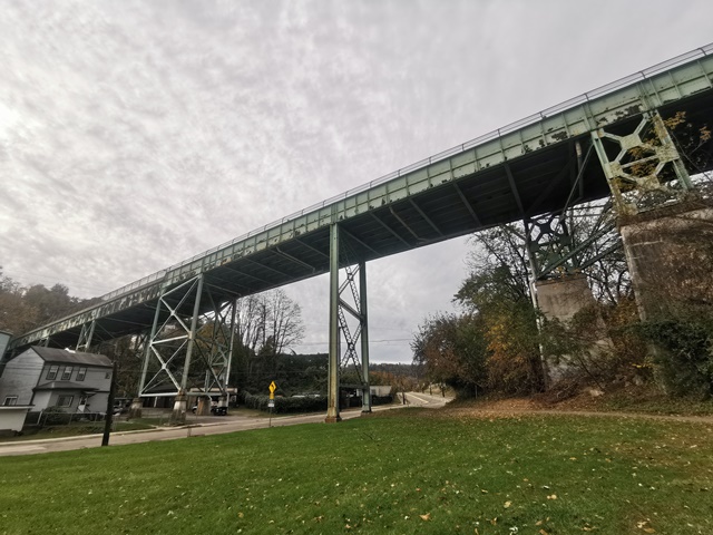
This is a high level viaduct type structure, composed of riveted through plate girder spans.
Information and Findings From Pennsylvania's Historic Bridge InventoryDiscussion of Bridge The skewed, 12 span, 586'-long bridge built in 1915 consists of 6 thru and 6 deck girder spans supported on concrete abutments and built up steel bent towers. In 1989 deck and railings were replaced with safety shape barriers and a concrete with a cantilevered sidewalk finished with a cnain link fence enclosure. Girder bridges are one of the most common bridge types in the state, first developed by the railroad industry in the mid 19th century, and they were used in numbers on Allegheny County highways beginning in the late 19th century. This bridge has innovative or distinctive details. It does not have a historically significant association with the B&O RR main line, one of the features it crosses. The bridge was built by the city as a replacement to a previous bridge over the ravine. The bridge is not historically or technologically distinguished by its setting or context. Discussion of Surrounding Area The bridge carries a 2 lane street and 1 sidewalk over a city street, a residential neighborhood, and 2 active CSXT railroad tracks in the Lower Greenfield section of Pittsburgh. The bridge spans between two undistinguished working class neighborhoods, Greenfield and Oakland. The railroad is the former main line of the B&O railroad. The north approach span of the viaduct passes under 02 0376 0034 0000, a bridge on the Penn-Lincoln Parkway East. Bridge Considered Historic By Survey: No |
![]()
![]()
![]()
Coordinates (Latitude, Longitude):
Search For Additional Bridge Listings:
Bridgehunter.com: View listed bridges within 0.5 miles (0.8 kilometers) of this bridge.
Bridgehunter.com: View listed bridges within 10 miles (16 kilometers) of this bridge.
Additional Maps:
Google Streetview (If Available)
GeoHack (Additional Links and Coordinates)
Apple Maps (Via DuckDuckGo Search)
Apple Maps (Apple devices only)
Android: Open Location In Your Map or GPS App
Flickr Gallery (Find Nearby Photos)
Wikimedia Commons (Find Nearby Photos)
Directions Via Sygic For Android
Directions Via Sygic For iOS and Android Dolphin Browser
USGS National Map (United States Only)
Historical USGS Topo Maps (United States Only)
Historic Aerials (United States Only)
CalTopo Maps (United States Only)

© Copyright 2003-2025, HistoricBridges.org. All Rights Reserved. Disclaimer: HistoricBridges.org is a volunteer group of private citizens. HistoricBridges.org is NOT a government agency, does not represent or work with any governmental agencies, nor is it in any way associated with any government agency or any non-profit organization. While we strive for accuracy in our factual content, HistoricBridges.org offers no guarantee of accuracy. Information is provided "as is" without warranty of any kind, either expressed or implied. Information could include technical inaccuracies or errors of omission. Opinions and commentary are the opinions of the respective HistoricBridges.org member who made them and do not necessarily represent the views of anyone else, including any outside photographers whose images may appear on the page in which the commentary appears. HistoricBridges.org does not bear any responsibility for any consequences resulting from the use of this or any other HistoricBridges.org information. Owners and users of bridges have the responsibility of correctly following all applicable laws, rules, and regulations, regardless of any HistoricBridges.org information.
![]()