


View Information About HSR Ratings
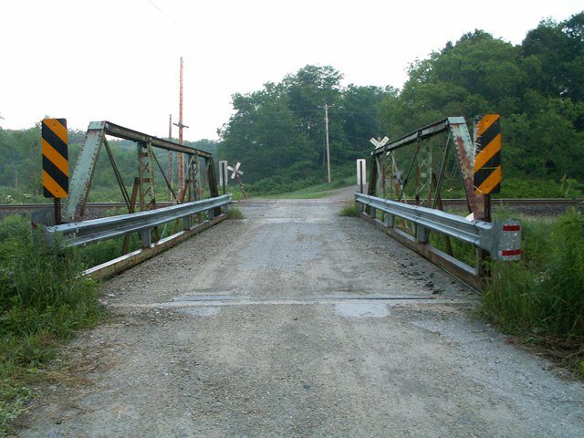
This bridge is on essentially on Wing Road, although the section of road that the bridge is on is listed as Canal Road, because for the length of just a bit over the 53 foot length of the bridge, Canal Road joins Wing Road to cross over the creek and continue paralleling Conneaut Creek on the other side.
For its length, this bridge seemed like it has rather tall trusses, yet it has a delicate appearance as well. For a half-hip pony truss, this is a short to medium length structure. Original railings do not remain on the bridge. There is lattice on the verticals. The bridge is composed of three panels. The bridge has been heavily modified, although the main parts of the bridge are still original. The inventory, happy to condemn a century-old bridge such as this, is quick to describe the non-original modifications. However, to those who appreciate the beauty of historic bridges actually look at this bridge, it is apparent that despite its modifications, still retains its original attractive overall appearance and should have been preserved. The replacement bridge will make clear how much this "altered" bridge still had left to offer visitors in terms of beauty and heritage, for the replacement will be devoid of both.
It should also be noted that as of 2013, many of those "complete pin connected truss bridges" that the Historic Bridge Inventory says are common in Crawford County have been or will soon be demolished. When this website began in 2003, Crawford County still had one of the most beautiful, diverse, and large collections of historic metal truss bridges in the country, and since then, it has been heartlessly destroying that collection one bridge at a time.
Information and Findings From Pennsylvania's Historic Bridge InventoryDiscussion of Bridge The ca. 1895, pin connected, single span, 53'-long, Pratt pony truss bridge is traditionally composed with built up box section upper chords, metal angle with lattice verticals, and eye bar diagonals. The structure was modified ca. 1980 when lower chord eye bars, diagonal eye and pins were replaced with material of different dimensions than the original and welded outriggers were added. The bridge is an altered example of its type and design, and it is not historically or technologically significant. Complete pin connected truss bridges are common in Crawford County. Discussion of Surrounding Area The bridge carries 1 lane of an unimproved road over a stream in a sparsely developed, wooded setting. A single Bessemer & Lake Erie Railroad track crosses the road at grade just west of the bridge. The area does not have historic district potential. Bridge Considered Historic By Survey: No |
![]()
![]()
![]()

![]()
![]()

![]()
This historic bridge has been demolished. This map is shown for reference purposes only.
Coordinates (Latitude, Longitude):
Search For Additional Bridge Listings:
Bridgehunter.com: View listed bridges within 0.5 miles (0.8 kilometers) of this bridge.
Bridgehunter.com: View listed bridges within 10 miles (16 kilometers) of this bridge.
Additional Maps:
Google Streetview (If Available)
GeoHack (Additional Links and Coordinates)
Apple Maps (Via DuckDuckGo Search)
Apple Maps (Apple devices only)
Android: Open Location In Your Map or GPS App
Flickr Gallery (Find Nearby Photos)
Wikimedia Commons (Find Nearby Photos)
Directions Via Sygic For Android
Directions Via Sygic For iOS and Android Dolphin Browser
USGS National Map (United States Only)
Historical USGS Topo Maps (United States Only)
Historic Aerials (United States Only)
CalTopo Maps (United States Only)

© Copyright 2003-2025, HistoricBridges.org. All Rights Reserved. Disclaimer: HistoricBridges.org is a volunteer group of private citizens. HistoricBridges.org is NOT a government agency, does not represent or work with any governmental agencies, nor is it in any way associated with any government agency or any non-profit organization. While we strive for accuracy in our factual content, HistoricBridges.org offers no guarantee of accuracy. Information is provided "as is" without warranty of any kind, either expressed or implied. Information could include technical inaccuracies or errors of omission. Opinions and commentary are the opinions of the respective HistoricBridges.org member who made them and do not necessarily represent the views of anyone else, including any outside photographers whose images may appear on the page in which the commentary appears. HistoricBridges.org does not bear any responsibility for any consequences resulting from the use of this or any other HistoricBridges.org information. Owners and users of bridges have the responsibility of correctly following all applicable laws, rules, and regulations, regardless of any HistoricBridges.org information.
![]()