We Recommend:
Bach Steel - Experts at historic truss bridge restoration.
BridgeHunter.com Phase 1 is released to the public! - Visit Now
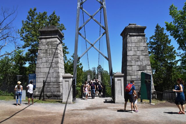
Pont de la Chute Montmorency (Montmorency Falls Bridge) (Towers Only)

Primary Photographer(s): Nathan Holth
Bridge Documented: July 11, 2019
Québec City and Boischatel: Capitale-Nationale, Québec: Canada
Not Available or Not Applicable
75.0 Feet (22.9 Meters)
300.0 Feet (91.4 Meters)
Not Available
4 Main Span(s)
Not Applicable

View Information About HSR Ratings
Bridge Documentation
Only the stone towers of this long-lost suspension bridge remain, with a modern suspension bridge spanning today. This webpage and listing is for the original stone towers only. The actual suspension bridge seen here today with its galvanized steel towers is modern and has no heritage value whatsoever. The stone towers once held a suspension bridge that dated to 1856. The current bridge dates to 1993.
Matthieu Lachance provided the following excellent history:
This bridge was built in 1856. It was plagued by design mistake (towers too low for the span) and poorly built (the cable's masonry anchorage in the ground were put in place with cement during winter and never cured correctly). The following spring, after very light use for a few months after it was put in service, the bridge dramatically collapsed in the falls after starting to fail for a few days, killing 3 people and a horse-driven carriage. An inquiry followed and found damning evidences of gross negligence by both the constructor and engineer. It was never rebuilt and all bridges since then have been rebuilt where the pre-1856 one was, a few hundred feet north of the Falls. The original 1856 suspension bridge design was based on Niagara Falls Suspension bridge... but it was a poor copy. No illustrations survive of that bridge due to its short life span. The decision to build a bridge there in 1856 was fueled by a desire of modernity and to create an extremely scenic view. Local population was wary of that bridge design and most people simply didn't cross it. It angered the bridge commissioners how they simply closed down the previous bridge at this location to force people to use the suspension bridge. The stone towers were kept as a memorial to the tragedy. I recall before 1993 that it was a impressive sight to see these massive pillars leading to an abyss because the street/pathway was still there...going nowhere.
This website has some additional information.
![]()
Photo Galleries and Videos: Pont de la Chute Montmorency (Montmorency Falls Bridge) (Towers Only)
Bridge Photo-Documentation
Original / Full Size PhotosA collection of overview and detail photos. This gallery offers photos in the highest available resolution and file size in a touch-friendly popup viewer.
Alternatively, Browse Without Using Viewer
![]()
Bridge Photo-Documentation
Mobile Optimized PhotosA collection of overview and detail photos. This gallery features data-friendly, fast-loading photos in a touch-friendly popup viewer.
Alternatively, Browse Without Using Viewer
![]()
Maps and Links: Pont de la Chute Montmorency (Montmorency Falls Bridge) (Towers Only)
Coordinates (Latitude, Longitude):
Search For Additional Bridge Listings:
Additional Maps:
Google Streetview (If Available)
GeoHack (Additional Links and Coordinates)
Apple Maps (Via DuckDuckGo Search)
Apple Maps (Apple devices only)
Android: Open Location In Your Map or GPS App
Flickr Gallery (Find Nearby Photos)
Wikimedia Commons (Find Nearby Photos)
Directions Via Sygic For Android
Directions Via Sygic For iOS and Android Dolphin Browser

