We Recommend:
Bach Steel - Experts at historic truss bridge restoration.
BridgeHunter.com Phase 1 is released to the public! - Visit Now
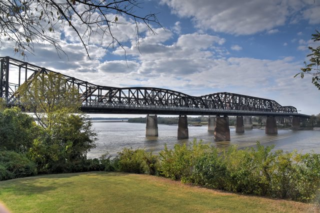
Harahan Bridge
Big River Crossing

Primary Photographer(s): Nathan Holth
Bridge Documented: November 6, 2016
Railroad (Union Pacific) and Big River Crossing Over Mississippi River
Memphis: Shelby County, Tennessee and Crittenden County, Arkansas: United States
Metal Cantilever 26 Panel Multiple-Type-Connected Baltimore Through Truss, Fixed and Approach Spans: Metal 10 Panel Pin-Connected Inverted Bowstring Deck Truss, Fixed
1916 By Builder/Contractor: Pennsylvania Steel Company of Steelton, Pennsylvania and Engineer/Design: Ralph Modjeski
2016
790.4 Feet (240.9 Meters)
4,973.0 Feet (1515.8 Meters)
Not Available
4 Main Span(s)
Not Applicable

View Information About HSR Ratings
Bridge Documentation
View Historical Articles About This Bridge
View Historical Thesis About This Bridge
View Tennessee Historic Bridge Report For This Historic Bridge
View the Official Big River Crossing Website
This bridge is a nationally significant historic bridge all on its own. What makes this setting even more unique is that this bridge sits right next to an even more significant historic bridge, the Frisco Bridge. To top this all off, the highway bridge that is also next to these two railroad bridges is also historic, and is the Memphis and Arkansas Bridge. Three historic cantilever truss bridges over the Mississippi River side by side, two of those bridges being nationally significant: there is no other historic bridge trio like this in North America.
While the Frisco Bridge was designed by one of the greatest bridge engineers of the 19th Century, the Harahan Bridge was similarly designed by one of the 20th Century's greatest bridge engineers, Ralph Modjeski. As such, works by two of the greatest engineers of their respective centuries can be seen side-by-side. This affords a unique comparison between both engineering thinking, and also changing needs of two different periods in railroad history.
The Harahan Bridge was designed to carry railroad traffic in between truss lines, and highway traffic on cantilevered decks outside of the truss lines. The construction of the Memphis and Arkansas Bridge ended the use of the Harahan Bridge for vehicular traffic. In 2016 however, a unique project converted the north vehicular deck into a pedestrian walkway named the Big River Crossing. This new walkway is unique because of its size, and also because it is rare for a railroad company to allow a public walkway to exist on one of their bridges. As might be expected, substantial fencing separates pedestrians from the railroad tracks. However, the truss is so large that despite the fencing, the walkway still offers excellent up-close views of the impressive details of the truss. Another important aspect of the walkway is that despite addition of modern railing on the outside, the original riveted lattice railings for the vehicular deck were not removed. This helps convey the former vehicular usage of the deck, and also maintains the original appearance of the bridge.
As part of the walkway, a modern full-color decorative lighting system was also installed, allowing for impressive light shows to bathe the entire bridge in a rainbow of animated colors. Note that if you visit this bridge in the evening and do not see the lights in operation, it may be due to a train or barge in the area, as this was a condition for the operation of the lighting system.
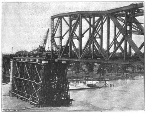
Above: Historical photo showing bridge construction.
Above: Historical photo showing bridge construction. Shown here is a 50 ton wedge used to adjust the position of the top chord near the suspended span. This was needed to fit the pieces together.
![]()
Photo Galleries and Videos: Harahan Bridge
Bridge Photo-Documentation
Original / Full Size PhotosA collection of overview and detail photos. This gallery offers photos in the highest available resolution and file size in a touch-friendly popup viewer.
Alternatively, Browse Without Using Viewer
![]()
Bridge Photo-Documentation
Mobile Optimized PhotosA collection of overview and detail photos. This gallery features data-friendly, fast-loading photos in a touch-friendly popup viewer.
Alternatively, Browse Without Using Viewer
![]()
Maps and Links: Harahan Bridge
Coordinates (Latitude, Longitude):
Search For Additional Bridge Listings:
Bridgehunter.com: View listed bridges within 0.5 miles (0.8 kilometers) of this bridge.
Bridgehunter.com: View listed bridges within 10 miles (16 kilometers) of this bridge.
Additional Maps:
Google Streetview (If Available)
GeoHack (Additional Links and Coordinates)
Apple Maps (Via DuckDuckGo Search)
Apple Maps (Apple devices only)
Android: Open Location In Your Map or GPS App
Flickr Gallery (Find Nearby Photos)
Wikimedia Commons (Find Nearby Photos)
Directions Via Sygic For Android
Directions Via Sygic For iOS and Android Dolphin Browser
USGS National Map (United States Only)
Historical USGS Topo Maps (United States Only)
Historic Aerials (United States Only)
CalTopo Maps (United States Only)


