

View Information About HSR Ratings
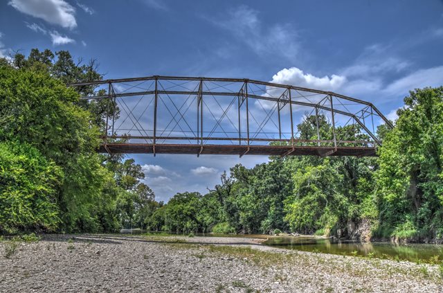
This impressive pin-connected Parker truss bridge has been closed to vehicular traffic for many years, but recent deck planks added to the bridge in some areas show that it appears to be somewhat maintained for pedestrian use. This is a stark contrast to the many totally abandoned and neglected historic bridges in Texas. The Texas Historical Commission states that Hess and Skinner Engineering Company were agents for the Missouri Valley Bridge Company for this bridge. It is assumed they refer to the Missouri Valley Bridge and Iron Works. As for Hess and Skinner Engineering Company, little is known about this company except that one of the owners was named Frederick Edward Hess.
Information and Findings From Texas Historical CommissionMarker Text In July 1913, the Bell County Commissioners Court, in response to repeated flooding in this area, approved construction of a bridge at this site to provide access to Killeen for residents of the Maxdale Community. Before it was completed, however, the bridge was destroyed in a flood. The Bell County Commissioners Court contracted again with Hess & Skinner Engineers, agents for the Missouri Valley Bridge Company, to build this bridge. Completed in 1914, the Maxdale Bridge employs a Parker truss design, which allows for maximum strength at mid-span. Recorded Texas Historic Landmark - 1990 Bridge Considered Historic By Survey: Yes |
![]()
![]()
![]()
Coordinates (Latitude, Longitude):
Search For Additional Bridge Listings:
Bridgehunter.com: View listed bridges within 0.5 miles (0.8 kilometers) of this bridge.
Bridgehunter.com: View listed bridges within 10 miles (16 kilometers) of this bridge.
Additional Maps:
Google Streetview (If Available)
GeoHack (Additional Links and Coordinates)
Apple Maps (Via DuckDuckGo Search)
Apple Maps (Apple devices only)
Android: Open Location In Your Map or GPS App
Flickr Gallery (Find Nearby Photos)
Wikimedia Commons (Find Nearby Photos)
Directions Via Sygic For Android
Directions Via Sygic For iOS and Android Dolphin Browser
USGS National Map (United States Only)
Historical USGS Topo Maps (United States Only)
Historic Aerials (United States Only)
CalTopo Maps (United States Only)

© Copyright 2003-2026, HistoricBridges.org. All Rights Reserved. Disclaimer: HistoricBridges.org is a volunteer group of private citizens. HistoricBridges.org is NOT a government agency, does not represent or work with any governmental agencies, nor is it in any way associated with any government agency or any non-profit organization. While we strive for accuracy in our factual content, HistoricBridges.org offers no guarantee of accuracy. Information is provided "as is" without warranty of any kind, either expressed or implied. Information could include technical inaccuracies or errors of omission. Opinions and commentary are the opinions of the respective HistoricBridges.org member who made them and do not necessarily represent the views of anyone else, including any outside photographers whose images may appear on the page in which the commentary appears. HistoricBridges.org does not bear any responsibility for any consequences resulting from the use of this or any other HistoricBridges.org information. Owners and users of bridges have the responsibility of correctly following all applicable laws, rules, and regulations, regardless of any HistoricBridges.org information.
![]()