

View Information About HSR Ratings
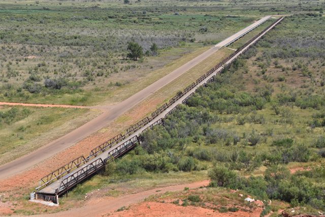
This bridge is among the longest pony truss bridges in terms of both span number and overall length in Texas and indeed the whole country, with a total of 30 spans, and an overall length of 2,471 feet. The bridge is highly significant for this reason. Additionally, it is regionally significant as one of a tiny number of historic bridges of any significance in the Texas Panhandle. The individual truss spans that compose the bridge as a whole are standard Texas pony trusses that were used throughout the state. Field connections on the bridge were bolted, and shop connections were riveted. Built-up members are riveted. Top chord and end post are rolled i-beams.
In 2013, this bridge was bypassed by a much shorter highway bridge that only is 1,360 feet long. The truss spans of the bridge were left in place and abandoned. Small approach spans at the south end and dirt at the north end were removed.
This bridge is located in a very rural setting. Long ago, there was a small town called Plemons near this bridge, but all traces of the town have been demolished. A historical photo of the town is shown below.

![]()
![]()
![]()
Use care if using a GPS to navigate to this bridge. Do NOT attempt to approach this bridge from Plemons Road south of the bridge as it is gated off and closed. Do NOT attempt to use TX-119 to reach the bridge as this road goes into the Conoco Phillips property and is closed to the public. Approach using Plemons Road from the north, or from the south using Farm to Market 280, although note it turns into gravel road CR-V before reaching the bridge.
Coordinates (Latitude, Longitude):
Search For Additional Bridge Listings:
Bridgehunter.com: View listed bridges within 0.5 miles (0.8 kilometers) of this bridge.
Bridgehunter.com: View listed bridges within 10 miles (16 kilometers) of this bridge.
Additional Maps:
Google Streetview (If Available)
GeoHack (Additional Links and Coordinates)
Apple Maps (Via DuckDuckGo Search)
Apple Maps (Apple devices only)
Android: Open Location In Your Map or GPS App
Flickr Gallery (Find Nearby Photos)
Wikimedia Commons (Find Nearby Photos)
Directions Via Sygic For Android
Directions Via Sygic For iOS and Android Dolphin Browser
USGS National Map (United States Only)
Historical USGS Topo Maps (United States Only)
Historic Aerials (United States Only)
CalTopo Maps (United States Only)

© Copyright 2003-2026, HistoricBridges.org. All Rights Reserved. Disclaimer: HistoricBridges.org is a volunteer group of private citizens. HistoricBridges.org is NOT a government agency, does not represent or work with any governmental agencies, nor is it in any way associated with any government agency or any non-profit organization. While we strive for accuracy in our factual content, HistoricBridges.org offers no guarantee of accuracy. Information is provided "as is" without warranty of any kind, either expressed or implied. Information could include technical inaccuracies or errors of omission. Opinions and commentary are the opinions of the respective HistoricBridges.org member who made them and do not necessarily represent the views of anyone else, including any outside photographers whose images may appear on the page in which the commentary appears. HistoricBridges.org does not bear any responsibility for any consequences resulting from the use of this or any other HistoricBridges.org information. Owners and users of bridges have the responsibility of correctly following all applicable laws, rules, and regulations, regardless of any HistoricBridges.org information.
![]()