We Recommend:
Bach Steel - Experts at historic truss bridge restoration.
BridgeHunter.com Phase 1 is released to the public! - Visit Now
Sunshine Road Bridge

Primary Photographer(s): Nathan Holth
Bridge Documented: August 1, 2019
Rural: Bell County, Texas: United States
By Builder/Contractor: Unknown
Not Available or Not Applicable
161.0 Feet (49.1 Meters)
190.0 Feet (57.9 Meters)
14.8 Feet (4.51 Meters)
1 Main Span(s)
90140AA0382001

View Information About HSR Ratings
Bridge Documentation
This bridge's future is at risk!
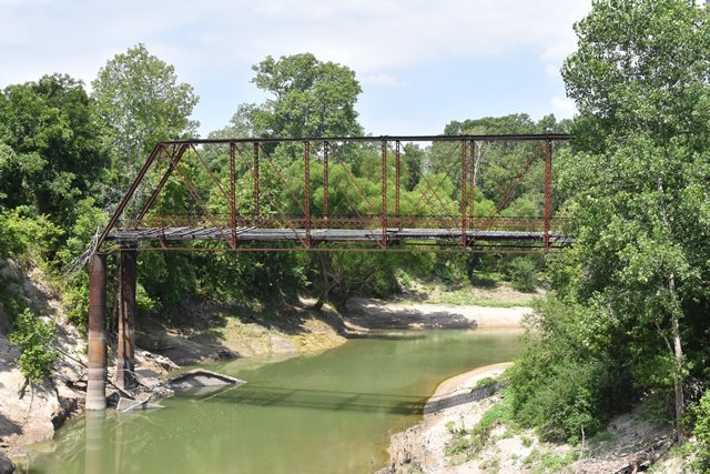
Bridge Status: This bridge is at severe risk for collapse due to deteriorating caissons!Bypassed and abandoned for many years, this bridge's unusually tall substructure is failing, putting the bridge at severe risk for collapse. This bridge is a traditionally composed Pratt truss that is also noted for its beautiful riveted fishbelly floorbeams.
Texas is in an unusual position in terms of its historic bridge preservation effort. Unlike states with a horrible preservation track record like Pennsylvania or Missouri, Texas has been willing to leave bridges standing next to a replacement bridge. This is a positive thing, since even abandoning a bridge next to a replacement is better than demolishing it. Even if the bridge is no longer maintained, it might stand for many decades as-is. Over those decades, the idea should be that eventually a reuise opportunity might come alone. The bridge might be restored for pedestrian use in place, or perhaps relocated and preserved elsewhere. This is where Texas falls short however. The bridges never get preserved. Even worse because some of the bypassed bridges were agreed to be "monumented" (abandoned) as part of a Section 106 Review, this presents legal challenges if someone wants to relocate the bridge, since the Memorandum of Agreements state that the bridge must be "monumented" and does not allow for relocation at a later date. This is a serious problem. This bridge demonstrates why. The unusually tall steel caissons this bridge sits on are no longer stabloe. One of them is tipping over slowly and taking the truss bridge with it. The twisting of the truss bridge is visible even from the distance of the new bridge where the bridge can be seen. It is only a matter of time until this bridge collapses. Sadly, this has been the fate of many of the bridges that have been "monumented" in Texas. To be clear, there is nothing wrong with monumenting a truss bridge. Indeed, it would be nice if other states like Pennsylvania did it. But to ultimately be successful, there still needs to be an avenue for relocating or preserving such bridges in the decades after the initial abandonment.
![]()
Photo Galleries and Videos: Sunshine Road Bridge
Bridge Photo-Documentation
Original / Full Size PhotosA collection of overview and detail photos. This gallery offers photos in the highest available resolution and file size in a touch-friendly popup viewer.
Alternatively, Browse Without Using Viewer
![]()
Bridge Photo-Documentation
Mobile Optimized PhotosA collection of overview and detail photos. This gallery features data-friendly, fast-loading photos in a touch-friendly popup viewer.
Alternatively, Browse Without Using Viewer
![]()
Maps and Links: Sunshine Road Bridge
Coordinates (Latitude, Longitude):
Search For Additional Bridge Listings:
Bridgehunter.com: View listed bridges within 0.5 miles (0.8 kilometers) of this bridge.
Bridgehunter.com: View listed bridges within 10 miles (16 kilometers) of this bridge.
Additional Maps:
Google Streetview (If Available)
GeoHack (Additional Links and Coordinates)
Apple Maps (Via DuckDuckGo Search)
Apple Maps (Apple devices only)
Android: Open Location In Your Map or GPS App
Flickr Gallery (Find Nearby Photos)
Wikimedia Commons (Find Nearby Photos)
Directions Via Sygic For Android
Directions Via Sygic For iOS and Android Dolphin Browser
USGS National Map (United States Only)
Historical USGS Topo Maps (United States Only)
Historic Aerials (United States Only)
CalTopo Maps (United States Only)

