

View Information About HSR Ratings

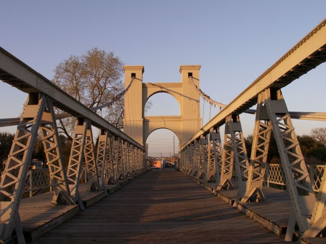
This bridge was one of the largest suspension bridge spans in the world when the original structure was completed in late 1869/early 1870. In 1913/1914, most of the original bridge structure was replaced, including the cables and stiffening trusses. As such, a 1914 construction date can easily be argued to be more appropriate for this bridge. The large brick towers appear to be the only major remnant of the original bridge and even they appear to be substantially altered from the original design. Despite this, even when considered a 1914 bridge, this structure is a rare example of its type, and an extremely beautiful suspension bridge that forms a historical centerpiece for Waco. Large pony stiffening truss with built-up beams featuring attractive v-lacing, riveted lattice railings, and towers with arched bracing make this bridge attractive.

The bridge features a warren pony truss approach span at the northern end of the bridge.
The bridge has been preserved for non-motorized use, having been closed to vehicular traffic in 1970.
The original 1870 bridge was shown in two places on an 1873 Bird's Eye View map of Waco. These images are shown on this page.

Bridge Summary From National Register of Historic Places Nomination FormDiscussion of Bridge An early suspension bridge with two double cable
towers of pink brick (now stuccoed) with superimposed arches connecting
the two piers of each tower and crossing the road bed. Toll houses and
walls terminate both ends of the bridge. The original crenellation,
pierced openings, and fine detail has been removed or stuccoed over, but
the general lines of the structures are still architecturally
interesting. The toll houses have stepped gable roofs, parapets, and
round arched openings now closed up. Bridge Considered Historic By Survey: Yes, this bridge is listed with reference number 70000850. |
![]()
![]()
![]()
Coordinates (Latitude, Longitude):
Search For Additional Bridge Listings:
Bridgehunter.com: View listed bridges within 0.5 miles (0.8 kilometers) of this bridge.
Bridgehunter.com: View listed bridges within 10 miles (16 kilometers) of this bridge.
Additional Maps:
Google Streetview (If Available)
GeoHack (Additional Links and Coordinates)
Apple Maps (Via DuckDuckGo Search)
Apple Maps (Apple devices only)
Android: Open Location In Your Map or GPS App
Flickr Gallery (Find Nearby Photos)
Wikimedia Commons (Find Nearby Photos)
Directions Via Sygic For Android
Directions Via Sygic For iOS and Android Dolphin Browser
USGS National Map (United States Only)
Historical USGS Topo Maps (United States Only)
Historic Aerials (United States Only)
CalTopo Maps (United States Only)

© Copyright 2003-2026, HistoricBridges.org. All Rights Reserved. Disclaimer: HistoricBridges.org is a volunteer group of private citizens. HistoricBridges.org is NOT a government agency, does not represent or work with any governmental agencies, nor is it in any way associated with any government agency or any non-profit organization. While we strive for accuracy in our factual content, HistoricBridges.org offers no guarantee of accuracy. Information is provided "as is" without warranty of any kind, either expressed or implied. Information could include technical inaccuracies or errors of omission. Opinions and commentary are the opinions of the respective HistoricBridges.org member who made them and do not necessarily represent the views of anyone else, including any outside photographers whose images may appear on the page in which the commentary appears. HistoricBridges.org does not bear any responsibility for any consequences resulting from the use of this or any other HistoricBridges.org information. Owners and users of bridges have the responsibility of correctly following all applicable laws, rules, and regulations, regardless of any HistoricBridges.org information.
![]()