

View Information About HSR Ratings
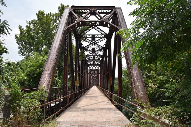
Bridge History and Design
This bridge was originally built as a railroad bridge, and included a single lane cantilevered deck on one side for vehicular traffic.When the bridge was abandoned by the railroad in 1965, the main railroad deck was converted for vehicular use. In ca. 2014 plans came together for a new highway bridge to the north, which as of 2019 had resulted in a complete new bridge. The historic bridge has been left standing next to its replacement for pedestrian use only, a positive preservation outcome.
In addition to the through truss spans, there are a couple unique approach spans at the west end. These approach spans are a hybrid of bridge types, with deck plate girders supporting the railroad deck, and unusual lightweight riveted deck trusses supporting the cantilever deck.
Local History Connection
Janis Head-Reasnor kindly shared a personal family story connected to the historic Carpenters Bluff Bridge. Her grandfather, Samuel "Sam" Wall, worked as a bridge foreman for the M.O.&G. Railroad and played a role in building the Carpenters Bluff Bridge. During construction, Sam and his family—including his wife Maggie, son Earl, and daughter Rosie Lee—lived in railroad cars near the bridge site until 1925. Sadly, Maggie became ill with tuberculosis and passed away in January 1926. Rather than place his children in an orphanage, Sam left the railroad just five years short of retirement and purchased an 80-acre farm from a Native American near Chickasaw Road in Colbert, Bryan County, Oklahoma, to raise his children. Years later, after they were grown, Sam returned to the Tulsa area, where he tragically died in 1955 when his car stalled on railroad tracks in Sapulpa and was struck by a train. His daughter Rosie brought him back to Colbert, where he was laid to rest. This story adds a human connection to the Carpenters Bluff Bridge and the people who helped build it.
Information and Findings From Texas Historical CommissionMarker Text Originally built as a railroad bridge for the Missouri, Oklahoma and Gulf (MO&G) Line, this landmark structure across the Red River continues to provide a transportation route between Grayson County, Texas, and Bryan County, Oklahoma. MO&G officials determined they needed a line through Grayson County to connect there with other railways in order to secure better freight rates for their shipments from the Oklahoma coal mines. The new line, under construction by 1910, entered Texas via this bridge at the small community known as Carpenters Bluff. Completed in the late summer of 1910, the Carpenters Bluff Bridge was designed to withstand major floods such as the one in 1908 that had destroyed several area bridges. Its design also included a wagon shelf, an extra lane to serve travelers on foot and horseback, as well as horse-drawn vehicles, all of whom had to pay a toll for its use. In 1921, ownership passed to the Kansas, Oklahoma and Gulf Railway Co., which maintained the line until 1965, when the company ceased operations in Texas due to declining rail traffic. The Texas & Pacific Railroad maintained the bridge for a brief time and then deeded it to the counties of Grayson and Bryan. County commissioners agreed to convert the structure for vehicular traffic, and upon completion of that work, the bridge was opened as a free public thoroughfare. Spanning the Red River since 1910, the Carpenters Bluff Bridge remains a significant part of Grayson County's history. (2002) Bridge Considered Historic By Survey: Yes |
![]()
![]()
![]()
Coordinates (Latitude, Longitude):
Search For Additional Bridge Listings:
Bridgehunter.com: View listed bridges within 0.5 miles (0.8 kilometers) of this bridge.
Bridgehunter.com: View listed bridges within 10 miles (16 kilometers) of this bridge.
Additional Maps:
Google Streetview (If Available)
GeoHack (Additional Links and Coordinates)
Apple Maps (Via DuckDuckGo Search)
Apple Maps (Apple devices only)
Android: Open Location In Your Map or GPS App
Flickr Gallery (Find Nearby Photos)
Wikimedia Commons (Find Nearby Photos)
Directions Via Sygic For Android
Directions Via Sygic For iOS and Android Dolphin Browser
USGS National Map (United States Only)
Historical USGS Topo Maps (United States Only)
Historic Aerials (United States Only)
CalTopo Maps (United States Only)

© Copyright 2003-2025, HistoricBridges.org. All Rights Reserved. Disclaimer: HistoricBridges.org is a volunteer group of private citizens. HistoricBridges.org is NOT a government agency, does not represent or work with any governmental agencies, nor is it in any way associated with any government agency or any non-profit organization. While we strive for accuracy in our factual content, HistoricBridges.org offers no guarantee of accuracy. Information is provided "as is" without warranty of any kind, either expressed or implied. Information could include technical inaccuracies or errors of omission. Opinions and commentary are the opinions of the respective HistoricBridges.org member who made them and do not necessarily represent the views of anyone else, including any outside photographers whose images may appear on the page in which the commentary appears. HistoricBridges.org does not bear any responsibility for any consequences resulting from the use of this or any other HistoricBridges.org information. Owners and users of bridges have the responsibility of correctly following all applicable laws, rules, and regulations, regardless of any HistoricBridges.org information.
![]()