

View Information About HSR Ratings
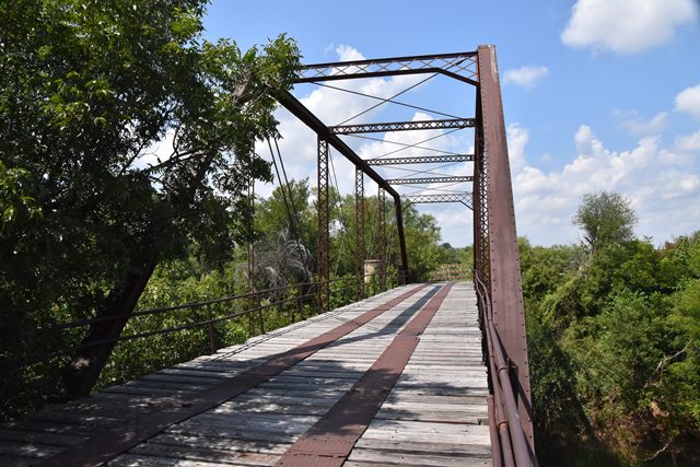
This bridge is an outstanding example of a Pratt truss bridge built by the King Bridge Company. An unusual detail can be found on the bottom chord near the hip vertical of the bridge. Here, the bottom chord does not connect to the vertical member, and instead the bottom chord has a pinned splice nearby. This detail, highly unusual on a Pratt truss bridge, seems reminiscent of the bottom chords of King Bridge Company bowstring truss bridges, where bottom chords were always spliced together in this manner. As such, this bridge shows some remnants of earlier design thinking of the 1870s continuing to survive into some of the 1880s designs of the company. The bridge is also noted for its built-up fishbelly floorbeams. The Historic American Engineering Record provided the following overview of the bridge: The Fort Griffin Iron Truss Bridge is the oldest functioning bridge in Shackelford County, Texas, and one of the state's oldest remaining trusses. It is also the last remaining pin-connected Pratt through truss in the county. Because it has survived with few alterations, the Fort Griffin Iron Truss Bridge is a remarkably intact example of an early metal truss bridge in Texas. Built to accommodate traffic between the county seats at Albany and Throckmorton, the bridge cuts through what used to Fort Griffin, a military checkpoint and cattle town. The Fort Griffin Iron Truss Bridge was nominated to the National Register of Historic Places in 1979.
![]()
![]()
![]()
Coordinates (Latitude, Longitude):
Search For Additional Bridge Listings:
Bridgehunter.com: View listed bridges within 0.5 miles (0.8 kilometers) of this bridge.
Bridgehunter.com: View listed bridges within 10 miles (16 kilometers) of this bridge.
Additional Maps:
Google Streetview (If Available)
GeoHack (Additional Links and Coordinates)
Apple Maps (Via DuckDuckGo Search)
Apple Maps (Apple devices only)
Android: Open Location In Your Map or GPS App
Flickr Gallery (Find Nearby Photos)
Wikimedia Commons (Find Nearby Photos)
Directions Via Sygic For Android
Directions Via Sygic For iOS and Android Dolphin Browser
USGS National Map (United States Only)
Historical USGS Topo Maps (United States Only)
Historic Aerials (United States Only)
CalTopo Maps (United States Only)

© Copyright 2003-2025, HistoricBridges.org. All Rights Reserved. Disclaimer: HistoricBridges.org is a volunteer group of private citizens. HistoricBridges.org is NOT a government agency, does not represent or work with any governmental agencies, nor is it in any way associated with any government agency or any non-profit organization. While we strive for accuracy in our factual content, HistoricBridges.org offers no guarantee of accuracy. Information is provided "as is" without warranty of any kind, either expressed or implied. Information could include technical inaccuracies or errors of omission. Opinions and commentary are the opinions of the respective HistoricBridges.org member who made them and do not necessarily represent the views of anyone else, including any outside photographers whose images may appear on the page in which the commentary appears. HistoricBridges.org does not bear any responsibility for any consequences resulting from the use of this or any other HistoricBridges.org information. Owners and users of bridges have the responsibility of correctly following all applicable laws, rules, and regulations, regardless of any HistoricBridges.org information.
![]()