

View Information About HSR Ratings
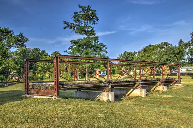
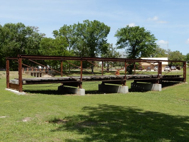
This is one of two historic bridges that were relocated and preserved in a small park named the Rockdale Bridge Park. The relocated bridges sit on the ground as exhibits. This bridge is a rare example of a bedstead truss bridge in Texas. Most of the legs below the bottom chord have been cut off, but otherwise the historic integrity is good. The bridge was originally located in Milam County, County Road 240 over Big Elm Creek. A new bridge was built at that location in 1988 per NBI data. The bridge was picked off the waterway and set to the north side of the creek in 1994. Sparks Engineering reports this bridge is wrought iron and suggests the reported 1912 construction date may be incorrect as a result.
Art Suckewer provided some possible insight into the construction date and potential for a different bridge builder:
I bought an old bridge contract. It is for a 70' bedstead over Elm Creek in Milam County, TX. The form has 188 printed on it with 91 overwritten (1891). The form has Kansas City Bridge Co. with Kansas City crossed out and Chicago written in. Thus, Galbreath Crossing Bridge is an 1891 Chicago Bridge product and it looks like Chicago bought Kansas City.
Further research into El Paso Bridge and Iron Company was difficult, however the company appears to have been more of an agent for other bridge builders. They may have still been involved with this bridge, perhaps erecting it for a company like Chicago Bridge.
This bridge is tagged with the following special condition(s): Trusses Converted To Decorative
![]()
![]()
![]()
![]()
![]()
Coordinates (Latitude, Longitude):
Search For Additional Bridge Listings:
Bridgehunter.com: View listed bridges within 0.5 miles (0.8 kilometers) of this bridge.
Bridgehunter.com: View listed bridges within 10 miles (16 kilometers) of this bridge.
Additional Maps:
Google Streetview (If Available)
GeoHack (Additional Links and Coordinates)
Apple Maps (Via DuckDuckGo Search)
Apple Maps (Apple devices only)
Android: Open Location In Your Map or GPS App
Flickr Gallery (Find Nearby Photos)
Wikimedia Commons (Find Nearby Photos)
Directions Via Sygic For Android
Directions Via Sygic For iOS and Android Dolphin Browser
USGS National Map (United States Only)
Historical USGS Topo Maps (United States Only)
Historic Aerials (United States Only)
CalTopo Maps (United States Only)

© Copyright 2003-2025, HistoricBridges.org. All Rights Reserved. Disclaimer: HistoricBridges.org is a volunteer group of private citizens. HistoricBridges.org is NOT a government agency, does not represent or work with any governmental agencies, nor is it in any way associated with any government agency or any non-profit organization. While we strive for accuracy in our factual content, HistoricBridges.org offers no guarantee of accuracy. Information is provided "as is" without warranty of any kind, either expressed or implied. Information could include technical inaccuracies or errors of omission. Opinions and commentary are the opinions of the respective HistoricBridges.org member who made them and do not necessarily represent the views of anyone else, including any outside photographers whose images may appear on the page in which the commentary appears. HistoricBridges.org does not bear any responsibility for any consequences resulting from the use of this or any other HistoricBridges.org information. Owners and users of bridges have the responsibility of correctly following all applicable laws, rules, and regulations, regardless of any HistoricBridges.org information.
![]()