We Recommend:
Bach Steel - Experts at historic truss bridge restoration.
BridgeHunter.com Phase 1 is released to the public! - Visit Now
139th Avenue Bridge

Primary Photographer(s): Nathan Holth
Bridge Documented: December 1, 2005 and March 11, 2007
Rural: Allegan County, Michigan: United States
Not Available or Not Applicable
42.0 Feet (12.8 Meters)
44.0 Feet (13.4 Meters)
16 Feet (4.88 Meters)
1 Main Span(s)
03318H00007B010

View Information About HSR Ratings
Bridge Documentation
This bridge no longer exists!
View Archived National Bridge Inventory Report - Has Additional Details and Evaluation
This historic bridge was demolished in 2007, but some parts were reused for a mobile display!
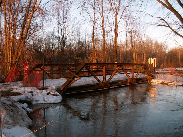
This bridge was an intact example of small warren pony truss bridge construction. The connections on the bridge were riveted. Original simple channel railings remained on the bridge. The bridge had no v-lacing or lattice making it a relatively simple looking bridge. It was a good example of late truss bridge construction in Michigan, with a 1920 construction date. An Illinois steel brand was present on the top chord of the bridge. The structure had appeared to have been closed within five years or so based on the lack of growth on the road leading up to the bridge when Allegan County decided to demolish and replace this quaint little bridge.
Sadly, this bridge was in severely poor condition from a feasibility of restoration standpoint. Large amounts of section loss was present on the bottom chord and several other portions of the truss structure. However, Vern Mesler, leading riveting researcher and historic bridge restoration expert was able to secure parts of this bridge's trusses and he restored a small section of one of the truss top chords and put it on a rolling cart, with all the parts of the bridge labeled, creating a mobile truss bridge display. A photo of the original historic bridge is part of the display so viewers know where it came from. It has been used annually at the Lansing Community College's Iron and Steel Preservation Conference as a display for attendees to learn about the parts of a truss bridge. So in this way, a part of the bridge lives on as a valuable teaching tool.
The replacement bridge is so ugly and plain it doesn't even look like a bridge, merely a section of roadway with guardrails. The proposed replacement bridge as was shown in the bid package is displayed below.

This bridge is tagged with the following special condition(s): Unorganized Photos
![]()
Photo Galleries and Videos: 139th Avenue Bridge
Bridge Photo-Documentation
A collection of overview and detail photos. This photo gallery contains a combination of Original Size photos and Mobile Optimized photos in a touch-friendly popup viewer.Alternatively, Browse Without Using Viewer
![]()
Additional Unorganized Photos
Original / Full Size PhotosThis photo gallery features older ca. 2003-2006 photos taken when the website only included a few photos in original size on the website, and a smaller quantity of reduced size photos as well. This unorganized gallery may partially duplicate photos in other galleries on this bridge's page, however all photos here are available in the Original / Full Size. This gallery offers photos in the highest available resolution and file size in a touch-friendly popup viewer.
Alternatively, Browse Without Using Viewer
![]()
Additional Unorganized Photos
Mobile Optimized PhotosThis photo gallery features older ca. 2003-2006 photos taken when the website only included a few photos in original size on the website, and a smaller quantity of reduced size photos as well. This unorganized gallery may partially duplicate photos in other galleries on this bridge's page, however all photos here are available in the Original / Full Size. This gallery features data-friendly, fast-loading photos in a touch-friendly popup viewer.
Alternatively, Browse Without Using Viewer
![]()
Maps and Links: 139th Avenue Bridge
This historic bridge has been demolished. This map is shown for reference purposes only.
Coordinates (Latitude, Longitude):
Search For Additional Bridge Listings:
Bridgehunter.com: View listed bridges within 0.5 miles (0.8 kilometers) of this bridge.
Bridgehunter.com: View listed bridges within 10 miles (16 kilometers) of this bridge.
Additional Maps:
Google Streetview (If Available)
GeoHack (Additional Links and Coordinates)
Apple Maps (Via DuckDuckGo Search)
Apple Maps (Apple devices only)
Android: Open Location In Your Map or GPS App
Flickr Gallery (Find Nearby Photos)
Wikimedia Commons (Find Nearby Photos)
Directions Via Sygic For Android
Directions Via Sygic For iOS and Android Dolphin Browser
USGS National Map (United States Only)
Historical USGS Topo Maps (United States Only)
Historic Aerials (United States Only)
CalTopo Maps (United States Only)


