We Recommend:
Bach Steel - Experts at historic truss bridge restoration.
BridgeHunter.com Phase 1 is released to the public! - Visit Now
Bach Driveway Bridge North
Bayport Road Driveway Bridge North

Primary Photographer(s): Nathan Holth
Bridge Documented: March 10, 2005
Rural: Huron County, Michigan: United States
By Builder/Contractor: Massillon Bridge Company of Massillon, Ohio, Smith - Wynkoop and McGormley Agents
Not Available or Not Applicable
Not Available
Not Available
Not Available
1 Main Span(s)
Not Applicable

View Information About HSR Ratings
Bridge Documentation
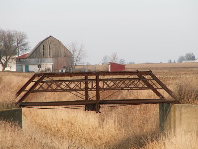
This is a unique setting where two private driveway pony truss bridges sit within sight of each other. Click here to view the page and photos for the other bridge. Despite the fact that they serve the same purpose, cross the same drain, and are only a short distance from each other, they are not identical. In general they are the same, but some of the design details are different, and the plaques on them are different. These bridges are the shortest form of a Pratt truss you can get, as two panels. Original lattice guardrails adorn both bridges. The bottom chord on the southern bridge is made up of eye-bars, whereas the northern one is composed of steel channels. Perhaps the northern bridge was built a year before or after, accounting for the differences in the bridge. The deck is gone from the northern bridge. The northern bridge appears to have been built to provide access to the farmlands. The southern bridge retains most of its wooden deck, and it appears to have originally provided access to a house, which is no longer around.
This bridge's plaque does not state the builder, unlike the southern bridge. Although the plaque has a different shape than the southern bridge, it may have been built by the same company (Toledo-Massillon Bridge Company of Toledo, Ohio Wynkoop and McGormley, Agents) or at least one of the variations of that company (which changed its name and organization over the years). Some other bridges associated with Wynkoop and McGormley have the same plaque shape as this bridge. Another bridge with a similar plaque design listed Massillon Bridge Company of Massillon, Ohio, Smith - Wynkoop and McGormley Agents as the builder.
![]()
Photo Galleries and Videos: Bach Driveway Bridge North
Bridge Photo-Documentation
Original / Full Size PhotosA collection of overview and detail photos. This gallery offers photos in the highest available resolution and file size in a touch-friendly popup viewer.
Alternatively, Browse Without Using Viewer
![]()
Bridge Photo-Documentation
Mobile Optimized PhotosA collection of overview and detail photos. This gallery features data-friendly, fast-loading photos in a touch-friendly popup viewer.
Alternatively, Browse Without Using Viewer
![]()
Maps and Links: Bach Driveway Bridge North
Coordinates (Latitude, Longitude):
Search For Additional Bridge Listings:
Bridgehunter.com: View listed bridges within 0.5 miles (0.8 kilometers) of this bridge.
Bridgehunter.com: View listed bridges within 10 miles (16 kilometers) of this bridge.
Additional Maps:
Google Streetview (If Available)
GeoHack (Additional Links and Coordinates)
Apple Maps (Via DuckDuckGo Search)
Apple Maps (Apple devices only)
Android: Open Location In Your Map or GPS App
Flickr Gallery (Find Nearby Photos)
Wikimedia Commons (Find Nearby Photos)
Directions Via Sygic For Android
Directions Via Sygic For iOS and Android Dolphin Browser
USGS National Map (United States Only)
Historical USGS Topo Maps (United States Only)
Historic Aerials (United States Only)
CalTopo Maps (United States Only)

