We Recommend:
Bach Steel - Experts at historic truss bridge restoration.
BridgeHunter.com Phase 1 is released to the public! - Visit Now
Bayfield Bridge

Primary Photographer(s): Nathan Holth
Bridge Documented: December 28, 2005
Bayfield: Huron County, Ontario: Canada
2010
101.7 Feet (31 Meters)
203.4 Feet (62 Meters)
Not Available
2 Main Span(s)
Not Applicable

View Information About HSR Ratings
Bridge Documentation
This bridge no longer exists!
Bridge Status: Demolished and replaced in 2021.Information from Ontario Bridge Inventory: Bridge width: 11.7 meters. Rehabilitation in 2000 and 2010.

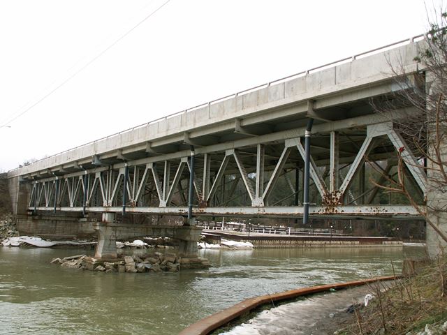
Who would have thought that beneath such an ugly, modern concrete deck would lie a beautiful two-span deck truss? The only clue from on the roadway is that the bridge lacks the enormous shoulders that are typical on a modern bridge.
This bridge is a two-span Warren deck truss. The bridge's connections are riveted, and the bridge sits on concrete abutments. The center pier is also concrete, and has an attractive arch-like design to it. V-lacing is present on many members of the bridge, adding greatly to the aesthetic qualities of the bridge. MTO provided a date of 1949 for the construction of this bridge. The deck and railings have been redone on the bridge. The trusses bear on short steel columns that look added, as if the bridge might have been raised at a later date. The paint on the bridge is grey. The steel trusses however, are showing rust in several location suggesting that for some unknown reason the trusses were not painted when the deck was redone.
King's Highway 21 is the main shoreline route as it proceeds north from Kings Highway 402 all the way up to Southampton. In between Highway 402 and Southampton, there are three truss bridges on the highway, somewhat uncommon among roads today in Ontario. The other two truss bridges are the Southampton Bridge, and the bridge over Au Sable River Cut.
Bayfield is a town that seems to take pride in being a small town with a historic feel to it. The truss bridge contributes its historic presence to the town as well, however it is not evident that any support for preservation of this bridge presented itself when the MTO proposed to demolish and replace this bridge.
The previous bridge at this location was a two span rivet-connected through truss. The bridge followed an unusual double-intersection Warren design that was used on a surprising number of bridges in Ontario in the early 20th Century, which is when the previous bridge likely dated to. This previous bridge was on a different alignment, and the concrete piers were left standing after the bridge was demolished.
![]()
Photo Galleries and Videos: Bayfield Bridge
April 11, 2015 Bridge Photo-Documentation
Original / Full Size PhotosA collection of overview and detail photos. This gallery offers photos in the highest available resolution and file size in a touch-friendly popup viewer.
Alternatively, Browse Without Using Viewer
![]()
April 11, 2015 Bridge Photo-Documentation
Mobile Optimized PhotosA collection of overview and detail photos. This gallery features data-friendly, fast-loading photos in a touch-friendly popup viewer.
Alternatively, Browse Without Using Viewer
![]()
December 28, 2005 Bridge Photo-Documentation
Original / Full Size PhotosA collection of overview and detail photos. This gallery offers photos in the highest available resolution and file size in a touch-friendly popup viewer.
Alternatively, Browse Without Using Viewer
![]()
December 28, 2005 Bridge Photo-Documentation
Mobile Optimized PhotosA collection of overview and detail photos. This gallery features data-friendly, fast-loading photos in a touch-friendly popup viewer.
Alternatively, Browse Without Using Viewer
![]()
Maps and Links: Bayfield Bridge
This historic bridge has been demolished. This map is shown for reference purposes only.
Coordinates (Latitude, Longitude):
Search For Additional Bridge Listings:
Additional Maps:
Google Streetview (If Available)
GeoHack (Additional Links and Coordinates)
Apple Maps (Via DuckDuckGo Search)
Apple Maps (Apple devices only)
Android: Open Location In Your Map or GPS App
Flickr Gallery (Find Nearby Photos)
Wikimedia Commons (Find Nearby Photos)
Directions Via Sygic For Android
Directions Via Sygic For iOS and Android Dolphin Browser


