

View Information About HSR Ratings
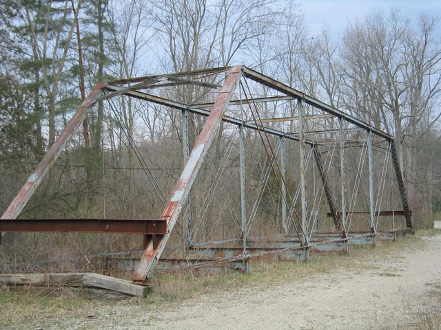
This is a six panel Pratt through truss. With its a-frame portal bracing and v-laced vertical members aligned so that the v-lacing faces the roadway, the bridge is a textbook example of the Wrought Iron Bridge Company's final standard truss design used in the 1890s in the years leading up to its acquisition by the American Bridge Company in 1900. The bridge has been moved off of its abutments and now rests on the grass near the river. The deck no longer remains on the bridge. Although there are traces of paint on the bridge, rust has done some visible damage to the bridge with some areas of section los noted. There appears to be some areas of the bridge that have had plates of steel welded to the heavily rusted areas of the bridge. No guardrails remain on the bridge.
This bridge was originally moved off so it could be preserved, but the idea came and went. No current plans are known for the bridge. Even though restoration has not been undertaken, the bridge remains standing, intact and feasible to restore. It is also protected from collapse. It had originally been seated on some of Michigan's notorious field stone abutments. A far cry from the ashlar stone substructures found in places like Pennsylvania, this type of field stone abutments is poorly constructed and does not do justice to the truss bridges they hold. A number of Michigan's historic truss bridges have been collapsed by these sorts of abutments, leading to the needless destruction of truss superstructures that were not in bad condition.
Off on the land, without a deck, repairs to the superstructure could be easily made. This bridge could perhaps be used somewhere in the Huron Mills Metro Park that is near the bridge. Although the bridge does not look as nice sitting on the grass, it is certainly not going to fall into the river. Hopefully someone will get some interest in this bridge and get this bridge fixed at least for pedestrian use. In the meantime, the bridge remains in place awaiting its future to be determined.
Information and Findings From Michigan Historic Bridge InventoryNarrative Description The Bell Road Bridge is one of only about ten nineteenth-century metal through truss highway bridges in Michigan. Spanning the Huron River, the bridge extends over 103 feet in length and has a width of thirteen feet. Constructed in 1891, the six-panel structure rests on fieldstone abutments. The Bell Road Bridge, now closed to vehicular traffic, is in a rural, largely wooded setting. It stands at the site of a nineteenth-century milling settlement known as Dover, of which little now survives. Statement of Significance The Wrought Iron Bridge Company of Canton, Ohio, was the most prolific builder of metal truss bridges in Michigan in the nineteenth century and this is the third oldest known surviving example of their work. |
This bridge is tagged with the following special condition(s): Available and Unorganized Photos
![]()
![]()
![]()
![]()
![]()
Coordinates (Latitude, Longitude):
Search For Additional Bridge Listings:
Bridgehunter.com: View listed bridges within 0.5 miles (0.8 kilometers) of this bridge.
Bridgehunter.com: View listed bridges within 10 miles (16 kilometers) of this bridge.
Additional Maps:
Google Streetview (If Available)
GeoHack (Additional Links and Coordinates)
Apple Maps (Via DuckDuckGo Search)
Apple Maps (Apple devices only)
Android: Open Location In Your Map or GPS App
Flickr Gallery (Find Nearby Photos)
Wikimedia Commons (Find Nearby Photos)
Directions Via Sygic For Android
Directions Via Sygic For iOS and Android Dolphin Browser
USGS National Map (United States Only)
Historical USGS Topo Maps (United States Only)
Historic Aerials (United States Only)
CalTopo Maps (United States Only)

© Copyright 2003-2026, HistoricBridges.org. All Rights Reserved. Disclaimer: HistoricBridges.org is a volunteer group of private citizens. HistoricBridges.org is NOT a government agency, does not represent or work with any governmental agencies, nor is it in any way associated with any government agency or any non-profit organization. While we strive for accuracy in our factual content, HistoricBridges.org offers no guarantee of accuracy. Information is provided "as is" without warranty of any kind, either expressed or implied. Information could include technical inaccuracies or errors of omission. Opinions and commentary are the opinions of the respective HistoricBridges.org member who made them and do not necessarily represent the views of anyone else, including any outside photographers whose images may appear on the page in which the commentary appears. HistoricBridges.org does not bear any responsibility for any consequences resulting from the use of this or any other HistoricBridges.org information. Owners and users of bridges have the responsibility of correctly following all applicable laws, rules, and regulations, regardless of any HistoricBridges.org information.
![]()