We Recommend:
Bach Steel - Experts at historic truss bridge restoration.
BridgeHunter.com Phase 1 is released to the public! - Visit Now
Bostick Road Bridge
Bill Blass Bridge, Turner Bridge, Allen County Bridge 268

Primary Photographer(s): Nathan Holth and Rick McOmber
Bridge Documented: April 2, 2006 and September 21, 2012
Rural: Allen County, Indiana: United States
Metal 13 Panel Pin-Connected Whipple (Double-Intersection Pratt) Through Truss, Fixed
1894 By Builder/Contractor: Canton Bridge Company of Canton, Ohio
2010
169.0 Feet (51.5 Meters)
174.0 Feet (53 Meters)
15.4 Feet (4.69 Meters)
1 Main Span(s)
200201

View Information About HSR Ratings
Bridge Documentation
View Archived National Bridge Inventory Report - Has Additional Details and Evaluation
A Brief Technical Overview

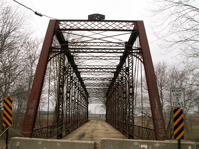
This bridge is a pin connected Whipple through truss. Whipple truss bridges are also referred to as double-intersection Pratt truss bridges. The bridge was built in 1894 by the Canton Bridge Company of Canton, Ohio. The bridge is composed of thirteen panels yielding a span of 165 feet. Extensive sway and portal bracing, which feature decorative curved designs in the corners, add to the intricate beauty that make up this bridge. Extensive v-lacing is present on the bridge, and lattice is present on the original railings, and the portal bracing. The bridge retains a great deal of historic integrity. The only noteworthy alteration was some small strips of steel added to a portion of the vertical members. Also, one guardrail panel was replaced. In 2006, the deck was composed of corrugated steel with an asphalt wearing surface. The bridge is a single-span structure, and sits on stone abutments. Prior to being closed in April 2004, the bridge was posted for a five ton weight limit. The bridge was overall in decent condition, with the exception of the floor beams which were in terrible shape with large areas of 100% section loss meaning there were gaping holes in the beams. Prior to restoration work in 2010, the Bostick Road Bridge weighed about 89,000 pounds without a deck surface and deck stringers.
2010 Restoration
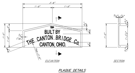
Representing an excellent win-win preservation scenario, this bridge was bypassed by a modern vehicular bridge with the historic bridge also being restored in place for non-motorized traffic. Substructure work included repointing of the masonry abutments. The deck was replaced with a more historically accurate timber deck. Original railings on the bridge were repaired and placed back on the bridge, and the one missing original panel was replaced with a panel resembling the original panels. In addition, to meet safety needs, modern railings were then installed on the deck. As might be expected, the floorbeams were replaced. Bearing and seat replacements and repairs were conducted. Pack rust was removed from the top chord using the method of hammering it out with an impact hammer, which is typical for a quality restoration project. An important feature of this project was that most failed rivets were replaced in-kind with rivets, and not the historically incorrect high strength bolts that have been traditionally used in the past during rehabilitation projects. This makes the Bostick Road Bridge one of a growing number of bridges that demonstrate that hot metal riveting is not a "lost art" but instead is a feasible technical process that can be specified in a contract special provision and easily undertaken by the on-site contractor. Another important feature of the restoration was that eyebars with section loss were not replaced, but instead were repaired by pad welding. Various repairs and replacements were made of deteriorated sections of overhead bracing and on the vertical members. Many of the pins on the bridge were replaced. The damaged builder plaque was used as a guide to create accurate replica plaques on the bridge. A drawing from the rehabilitation plans dictating the replication process is shown here.
Overall this is an excellent and model restoration project, and thanks to this the Bostick Road Bridge is ready for another century of existence. The only aspect of the project that could have been improved was the modern railing, which was specified to be a tall railing of wooden boards. There are other modern railings available in the market that meet safety requirements, but which do not obstruct the view of the historic bridge structure to the extent that wooden railings do. Another odd detail is that the replica builder plaques were not placed on top of the portal bracing as originally located, but instead are located within the lattice of the portal bracing. The reason for this change is unclear.
This bridge, despite its age, is steel and needs to be protected by paint. The vibrant green paint on the restored bridge not only protects the bridge but it also draws attention to this historic bridge.
Beaty Construction, Inc. of Boggstown, Indiana was awarded the contract for the project, which cost $1.13 million.
Information and Findings From DHPA Historic Bridge SurveyStatement of Significance The Allen County authorities made a major investment of time and energy in the design of the substructure and superstructure of a replacement bridge over this long-used crossing. It selected two important stone masons for the stone work and a notable and now under-represented Ohio fabricator to design and build the superstructure. The Whipple--often reserved as here for long spans--is increasingly rare in the Hoosier landscape. The Turner Bridge retains its original members, decorative portals, struts, knee braces, and latticed guardrails. Architectural Description Canton Bridge designed this pin-connected, double-intersection Pratt (Whipple) with through trusses carrying a 24-ft. depth. The 169-ft. span is subdivided into thirteen panels. Rod hangers supply the hip verticals. The intermediate ones were made from laced channels of four sizes decreasing toward center span (7.5, 6.5, 5.5, 4.75 in.) riveted to pin plates above and reinforcing pin plates below. A pair of die-forged eyebars provide each panel's diagonals except for the three most central panels where a pair of cylindrical eyebars with turnbuckles double as diagonals and counters. The high trusses are well braced. The portals have latticed struts and the intermediate verticals carry laced angles as struts at two points--between upper panel points and at about a third point below. The intermediate struts have decoratively laced knee braces. The bridge maintains 16 feet of vehicular clearance above the roadway. The rolled I floor-beams are U-bolted to the lower pins support the I-beam stingers which in turn carry the 15-ft. 6- in. asphalt-over-timber roadway. Wide latticed railings line the trusses. The cut stone abutments and wingwalls have been capped with concrete. Other Information The Board of Commissioners spent several days in April 1893 "on bridge work in Marion township." The commissioners' work led to the decision to replace the old bridge with a new one. In May the Board prepared for June bids, including specifications for specific iron truss members. In June, they accepted the Canton Bridge Company's bid of $3,320 for the Turner Bridge superstructure. The negotiated certain portions of the company's proposal, including an increase in the section of the cover plate of the top chord from 3/8 to .5 in. and of the end posts from 5/16 to 3/8 in. and the use of "steel joists" or stringers. The commissioners also wanted the trusses coated in graphite paint with boiled linseed oil. A month later, the Board spent two days in Canton, Ohio, "inspecting iron bridges in process of construction for crossing St. Mary's River at Hesse Cassel in Marion township." Earlier, the commissioners had visited Greensburg, Indiana, "inspecting stone for bridge work." The contract with McKee and Eck for only one stone abutment suggests the combination of an old one with a new one for what was at 169 ft. likely a longer span than the structure being replaced. McKee and Eck were required to use face and header stone from Greensburg quarries with "backing of stone from the old abutment." In August, the Board also contracted with H. W. Tapp for the construction of the west abutment of the Turner Bridge also of Greensburg stone. Apparently the commissioners finally decided to replace both old abutments. Bridge Considered Historic By Survey: Yes |
This bridge is tagged with the following special condition(s): Reused
![]()
Photo Galleries and Videos: Bostick Road Bridge
Bridge Before Rehabilitation
Original / Full Size PhotosA collection of overview and detail photos. This gallery offers photos in the highest available resolution and file size in a touch-friendly popup viewer.
Alternatively, Browse Without Using Viewer
![]()
Bridge Before Rehabilitation
Mobile Optimized PhotosA collection of overview and detail photos. This gallery features data-friendly, fast-loading photos in a touch-friendly popup viewer.
Alternatively, Browse Without Using Viewer
![]()
Bridge After Rehabilitation
Original / Full Size PhotosA collection of overview and detail photos. This gallery offers photos in the highest available resolution and file size in a touch-friendly popup viewer.
Alternatively, Browse Without Using Viewer
![]()
Bridge After-Documentation
Mobile Optimized PhotosA collection of overview and detail photos. This gallery features data-friendly, fast-loading photos in a touch-friendly popup viewer.
Alternatively, Browse Without Using Viewer
![]()
Maps and Links: Bostick Road Bridge
Coordinates (Latitude, Longitude):
Search For Additional Bridge Listings:
Bridgehunter.com: View listed bridges within 0.5 miles (0.8 kilometers) of this bridge.
Bridgehunter.com: View listed bridges within 10 miles (16 kilometers) of this bridge.
Additional Maps:
Google Streetview (If Available)
GeoHack (Additional Links and Coordinates)
Apple Maps (Via DuckDuckGo Search)
Apple Maps (Apple devices only)
Android: Open Location In Your Map or GPS App
Flickr Gallery (Find Nearby Photos)
Wikimedia Commons (Find Nearby Photos)
Directions Via Sygic For Android
Directions Via Sygic For iOS and Android Dolphin Browser
USGS National Map (United States Only)
Historical USGS Topo Maps (United States Only)
Historic Aerials (United States Only)
CalTopo Maps (United States Only)


