We Recommend:
Bach Steel - Experts at historic truss bridge restoration.
BridgeHunter.com Phase 1 is released to the public! - Visit Now
21 Mile Road Bridge

Primary Photographer(s): Nathan Holth
Bridge Documented: 2006 and November 8, 2012
Rural: Calhoun County, Michigan: United States
1885 By Builder/Contractor: Massillon Bridge Company of Massillon, Ohio
Not Available or Not Applicable
59.7 Feet (18.2 Meters)
59.7 Feet (18.2 Meters)
13 Feet (3.96 Meters)
1 Main Span(s)
13315H00020B010

View Information About HSR Ratings
Bridge Documentation
This bridge no longer exists!
Bridge Status: Demolished and replaced in 2019.View Archived National Bridge Inventory Report - Has Additional Details and Evaluation
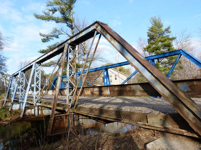
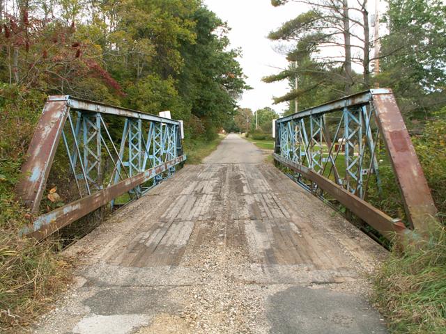
This bridge was built in 1885, making it a very old example of a half-hip pin connected Pratt pony truss in Michigan. Most Pratt pony trusses in Michigan are actually closed to traffic, but this one remains open with a decent 12 ton weight limit. An attractive blue paint is present on this bridge, but there is rust. This bridge was built by the Massillon Bridge company, and their distinctively-shaped plaque does not remain on the bridge, but its outline can be easily seen where it once was. This five panel bridge has a wooden deck and v-lacing on vertical members. The bridge has two notable alterations. First, the lattice railings do not remain, and plain steel railings have been added. Also, outriggers were added, and the main i-beams had extra steel added to support these buttresses. These outriggers probably helped this bridge continue to carry modern traffic, however.
In November 2012, an effort to put a new coat of paint on the bridge appeared to be underway. While it does not appear to be a comprehensive repainting, where rust would be blasted off and new paint applied to every exposed surface of the bridge, any effort to protect the bridge is certainly better than nothing. However, perhaps the most beneficial thing that was also done during this effort was that the dirt was dug out around the bearings. Dirt buildup around bearings leads to moisture buildup which in turn leads to deterioration. Removing this dirt will extend the life of the bridge.
Information and Findings From Michigan Historic Bridge InventoryNarrative Description This bridge is an early Pratt pony truss, built by the Massillon Bridge Company of Massillon, Ohio, a prolific metal truss bridge company in terms of bridges constructed in Michigan and the Midwest. |
This bridge is tagged with the following special condition(s): Unorganized Photos
![]()
Photo Galleries and Videos: 21 Mile Road Bridge
2012 Bridge Photo-Documentation
Original / Full Size PhotosA collection of overview and detail photos, taken 2012. This gallery offers photos in the highest available resolution and file size in a touch-friendly popup viewer.
Alternatively, Browse Without Using Viewer
![]()
2012 Bridge Photo-Documentation
Mobile Optimized PhotosA collection of overview and detail photos, taken 2012 This gallery features data-friendly, fast-loading photos in a touch-friendly popup viewer.
Alternatively, Browse Without Using Viewer
![]()
Additional, Earlier Bridge Photo-Documentation
A collection of overview and detail photos. This photo gallery contains a combination of Original Size photos and Mobile Optimized photos in a touch-friendly popup viewer.Alternatively, Browse Without Using Viewer
![]()
Additional Unorganized Photos
Original / Full Size PhotosThis photo gallery features older ca. 2003-2006 photos taken when the website only included a few photos in original size on the website, and a smaller quantity of reduced size photos as well. This unorganized gallery may partially duplicate photos in other galleries on this bridge's page, however all photos here are available in the Original / Full Size. This gallery offers photos in the highest available resolution and file size in a touch-friendly popup viewer.
Alternatively, Browse Without Using Viewer
![]()
Additional Unorganized Photos
Mobile Optimized PhotosThis photo gallery features older ca. 2003-2006 photos taken when the website only included a few photos in original size on the website, and a smaller quantity of reduced size photos as well. This unorganized gallery may partially duplicate photos in other galleries on this bridge's page, however all photos here are available in the Original / Full Size. This gallery features data-friendly, fast-loading photos in a touch-friendly popup viewer.
Alternatively, Browse Without Using Viewer
![]()
Northbound Crossing
Full Motion VideoStreaming video of the bridge. Also includes a higher quality downloadable video for greater clarity or offline viewing.
![]()
Maps and Links: 21 Mile Road Bridge
This historic bridge has been demolished. This map is shown for reference purposes only.
Coordinates (Latitude, Longitude):
Search For Additional Bridge Listings:
Bridgehunter.com: View listed bridges within 0.5 miles (0.8 kilometers) of this bridge.
Bridgehunter.com: View listed bridges within 10 miles (16 kilometers) of this bridge.
Additional Maps:
Google Streetview (If Available)
GeoHack (Additional Links and Coordinates)
Apple Maps (Via DuckDuckGo Search)
Apple Maps (Apple devices only)
Android: Open Location In Your Map or GPS App
Flickr Gallery (Find Nearby Photos)
Wikimedia Commons (Find Nearby Photos)
Directions Via Sygic For Android
Directions Via Sygic For iOS and Android Dolphin Browser
USGS National Map (United States Only)
Historical USGS Topo Maps (United States Only)
Historic Aerials (United States Only)
CalTopo Maps (United States Only)


