HistoricBridges.org Menu: HistoricBridges.org Menu:


We Recommend:
Bach Steel - Experts at historic truss bridge restoration.

HistoricBridges.org: Bridge Browser

22 1/2 Mile Road Bridge

22 1/2 Mile Road Bridge

Primary Photographer(s): Nathan Holth

Bridge Documented: Spring 2007 - April 23, 2022

View Photos
and Videos
View Maps
and Links

Facility Carried / Feature Intersected
22 1/2 Mile Road Over St. Joseph River
Location
Rural: Calhoun County, Michigan: United States
Construction Date and Builder / Engineer
1906 By Builder/Contractor: Elkhart Bridge and Iron Company of Elkhart, Indiana
Rehabilitation Date
Not Available or Not Applicable
Main Span Length
89.0 Feet (27.1 Meters)
Structure Length
90.0 Feet (27.4 Meters)
Roadway Width
15 Feet (4.57 Meters)
Spans
1 Main Span(s)
Inventory Number
13307H00013B010

Historic Significance Rating (HSR)
View Information About HSR Ratings

Bridge Documentation

View Archived National Bridge Inventory Report - Has Additional Details and Evaluation

This bridge is historically significant as the last remaining truss bridge in Michigan that has been associated with the Elkhart Bridge and Iron Company.

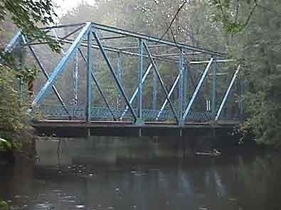
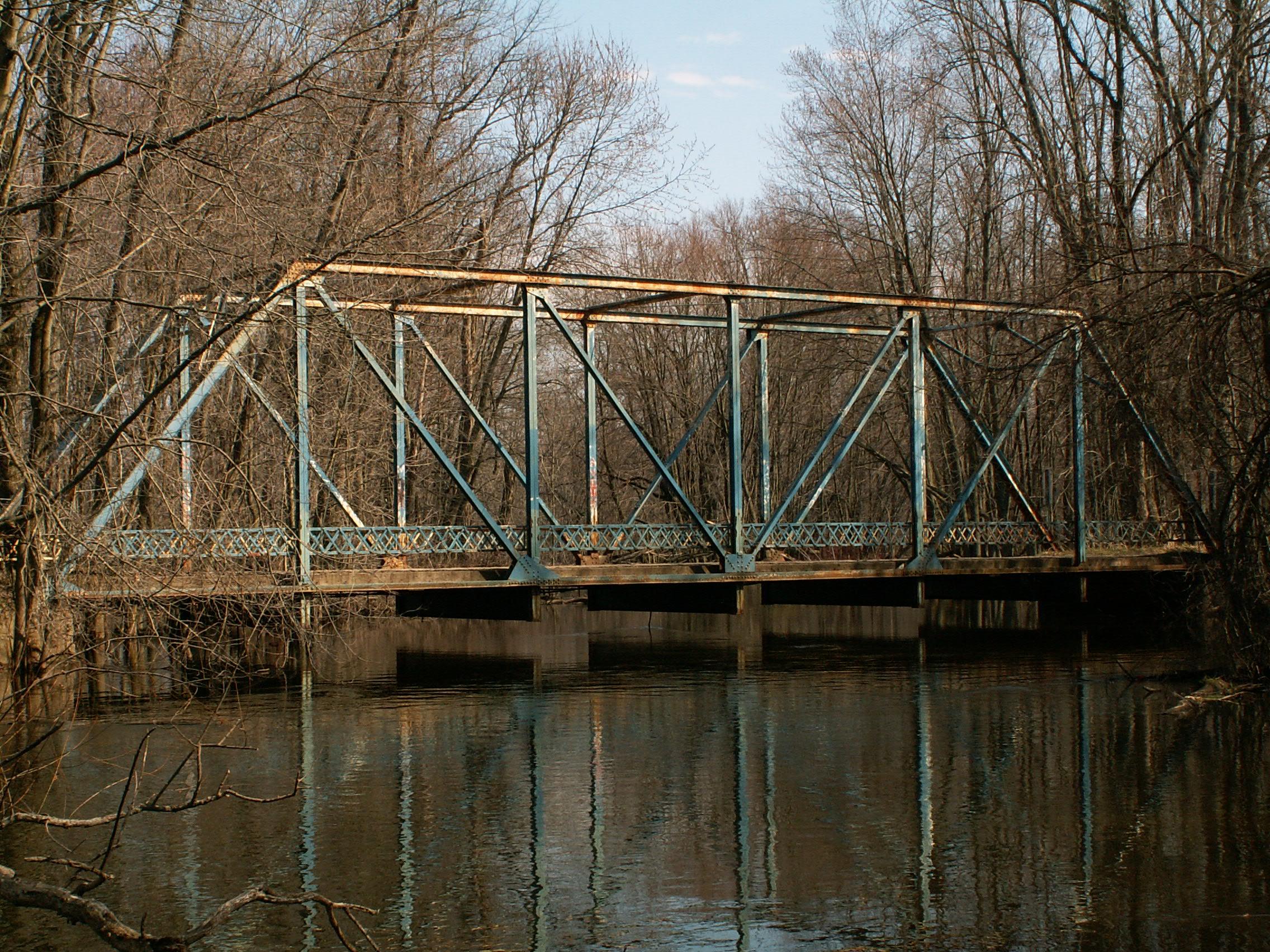
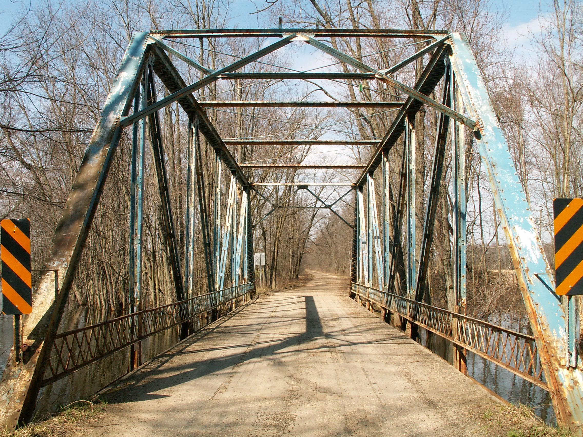
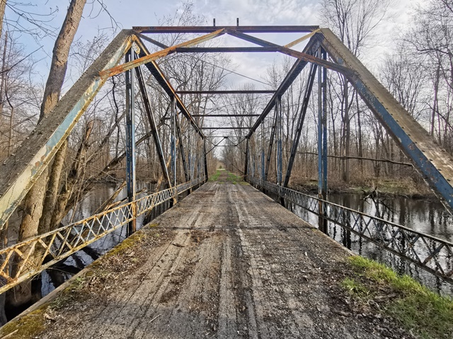
Most through truss bridges that have this general appearance, with a traditional trapezoidal design and fairly lightweight members, have pinned connections, but this bridge has riveted connections instead. Compare this bridge to the late Church Road Bridge, which was a similar structure. The 22 1/2 Mile Road Bridge is unusual because it lacks v-lacing on its vertical members. V-lacing is present under the top chord of this bridge however. This bridge is six panels in length, and sits on concrete abutments. The deck of the bridge is wood. The portal bracing is the a-frame design. Original lattice guardrails remain on this bridge. This bridge was listed with a 1906 construction date, which seems on-target for this design. In 2007, the bridge remained open to traffic with a 10 ton weight limit posted. An attractive blue paint is present on the bridge, but this bridge needs a fresh coat badly. The lower chord connections on this bridge are badly rusted. In fact, this bridge needs a total restoration. It would be great to see Calhoun County step forward and restore this bridge so it continue to carry 22 1/2 Mile Road's light vehicular traffic in its attractive wooded setting. By 2011, this bridge had been closed to all traffic. The future of this bridge is uncertain. Will the county that created the first historic bridge park in the country continue to lead the way in historic preservation by restoring this bridge? This bridge could economically be rehabilitated for continued light vehicular use in this rural location, likely for less than the cost of replacement. Michigan's Local Bridge Program provides funds for rehabilitation.

Information and Findings From Michigan Historic Bridge Inventory

MDOT Historic Bridge 22.5 Mile Rd. / St. Joseph River

Narrative Description

This bridge was built by the Elkhart Bridge and Iron Company of Elkhart, Indiana, one of many medium-sized metal truss bridge companies in the Midwest during the late nineteenth and early twentieth centuries.


This bridge is tagged with the following special condition(s): Available and Unorganized Photos

Divider

Photo Galleries and Videos: 22 1/2 Mile Road Bridge


View Photo Gallery

Original / Full Size Gallery

Original / Full Size Photos
For the best visual immersion and full detail, or for use as a desktop background, this gallery presents selected overview and detail photos for this bridge in the original digital camera resolution. This gallery offers photos in the highest available resolution and file size in a touch-friendly popup viewer.
Alternatively, Browse Without Using Viewer

Divider

View Photo Gallery

Structure Overview

Mobile Optimized Photos
A collection of overview photos that show the bridge as a whole and general areas of the bridge. This gallery features data-friendly, fast-loading photos in a touch-friendly popup viewer.
Alternatively, Browse Without Using Viewer

Divider

View Photo Gallery

Structure Details

Mobile Optimized Photos
A collection of detail photos that document the parts, construction, and condition of the bridge. This gallery features data-friendly, fast-loading photos in a touch-friendly popup viewer.
Alternatively, Browse Without Using Viewer

Divider

View Photo Gallery

Additional Unorganized Photos

Original / Full Size Photos
This photo gallery features older ca. 2003-2006 photos taken when the website only included a few photos in original size on the website, and a smaller quantity of reduced size photos as well. This unorganized gallery may partially duplicate photos in other galleries on this bridge's page, however all photos here are available in the Original / Full Size. This gallery offers photos in the highest available resolution and file size in a touch-friendly popup viewer.
Alternatively, Browse Without Using Viewer

Divider

View Photo Gallery

Additional Unorganized Photos

Mobile Optimized Photos
This photo gallery features older ca. 2003-2006 photos taken when the website only included a few photos in original size on the website, and a smaller quantity of reduced size photos as well. This unorganized gallery may partially duplicate photos in other galleries on this bridge's page, however all photos here are available in the Original / Full Size. This gallery features data-friendly, fast-loading photos in a touch-friendly popup viewer.
Alternatively, Browse Without Using Viewer

Divider

View Photo Gallery

2022 Additional Unorganized Photos

Original / Full Size Photos
A supplemental collection of photos that are from additional visit(s) to the bridge and have not been organized or captioned. This gallery offers photos in the highest available resolution and file size in a touch-friendly popup viewer.
Alternatively, Browse Without Using Viewer

Divider

View Photo Gallery

2022 Additional Unorganized Photos

Mobile Optimized Photos
A supplemental collection of photos that are from additional visit(s) to the bridge and have not been organized or captioned. This gallery features data-friendly, fast-loading photos in a touch-friendly popup viewer.
Alternatively, Browse Without Using Viewer

Divider

Maps and Links: 22 1/2 Mile Road Bridge

Coordinates (Latitude, Longitude):

Search For Additional Bridge Listings:

Bridgehunter.com: View listed bridges within 0.5 miles (0.8 kilometers) of this bridge.

Bridgehunter.com: View listed bridges within 10 miles (16 kilometers) of this bridge.

HistoricBridges.org Bridge Browser: View listed bridges within 0.5 miles (0.8 kilometers) of this bridge.

HistoricBridges.org Bridge Browser: View listed bridges within 10 miles (16 kilometers) of this bridge.

2021 National Bridge Inventory: View listed bridges within 0.5 miles (0.8 kilometers) of this bridge.

Additional Maps:

Google Maps

Google Streetview (If Available)

Bing Maps

OpenStreetMap

GeoHack (Additional Links and Coordinates)

Apple Maps (Via DuckDuckGo Search)

Apple Maps (Apple devices only)

MapQuest

HERE We Go Maps

ACME Mapper

Waze Map

Android: Open Location In Your Map or GPS App

Flickr Gallery (Find Nearby Photos)

Wikimedia Commons (Find Nearby Photos)

Directions Via Sygic For Android

Directions Via Sygic For iOS and Android Dolphin Browser

USGS National Map (United States Only)

Historical USGS Topo Maps (United States Only)

Historic Aerials (United States Only)

CalTopo Maps (United States Only)


Divider
 
Home Top

Divider

About - Contact

© Copyright 2003-2024, HistoricBridges.org. All Rights Reserved. Disclaimer: HistoricBridges.org is a volunteer group of private citizens. HistoricBridges.org is NOT a government agency, does not represent or work with any governmental agencies, nor is it in any way associated with any government agency or any non-profit organization. While we strive for accuracy in our factual content, HistoricBridges.org offers no guarantee of accuracy. Information is provided "as is" without warranty of any kind, either expressed or implied. Information could include technical inaccuracies or errors of omission. Opinions and commentary are the opinions of the respective HistoricBridges.org member who made them and do not necessarily represent the views of anyone else, including any outside photographers whose images may appear on the page in which the commentary appears. HistoricBridges.org does not bear any responsibility for any consequences resulting from the use of this or any other HistoricBridges.org information. Owners and users of bridges have the responsibility of correctly following all applicable laws, rules, and regulations, regardless of any HistoricBridges.org information.

Admin Login

Divider