

View Information About HSR Ratings
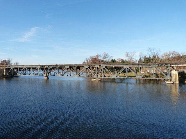
Michigan does not have a lot of deck truss bridges, mostly because a lack of deep river valleys create a small amount of clearance between the level of the approaching roadway and the river below. As such, deck truss bridges are not generally an appropriate choice in Michigan because such a structure would leave little clearance between bridge and water level. Clearance apparently was not a concern with this river however, as the bridge's trusses sit very close to the river. Normally this would be a risk since during a flood water could rise above the trusses and carry debris into them and causing damage. However, this section of the river acts as a reservoir for a dam located downstream, so it is presumed that the water level and flow can be controlled and does not rise up into a raging torrent after a rain storm or heavy snow melt events. Crossing a river made wider than normal by its reservoir function, the bridge is a fairly long one for Michigan, with three Warren deck truss spans and a deck plate girder approach at each end. The connections on the bridge are riveted. With many built-up beams, V-lacing is present on the diagonals and on some of the bracing. Lattice is present under the top chord. The bridge is also noteworthy for its skew, which is made apparent because the angle of the endposts of this bridge vary in angle, making the bridge look very odd.
![]()
![]()
![]()
Coordinates (Latitude, Longitude):
Search For Additional Bridge Listings:
Bridgehunter.com: View listed bridges within 0.5 miles (0.8 kilometers) of this bridge.
Bridgehunter.com: View listed bridges within 10 miles (16 kilometers) of this bridge.
Additional Maps:
Google Streetview (If Available)
GeoHack (Additional Links and Coordinates)
Apple Maps (Via DuckDuckGo Search)
Apple Maps (Apple devices only)
Android: Open Location In Your Map or GPS App
Flickr Gallery (Find Nearby Photos)
Wikimedia Commons (Find Nearby Photos)
Directions Via Sygic For Android
Directions Via Sygic For iOS and Android Dolphin Browser
USGS National Map (United States Only)
Historical USGS Topo Maps (United States Only)
Historic Aerials (United States Only)
CalTopo Maps (United States Only)

© Copyright 2003-2026, HistoricBridges.org. All Rights Reserved. Disclaimer: HistoricBridges.org is a volunteer group of private citizens. HistoricBridges.org is NOT a government agency, does not represent or work with any governmental agencies, nor is it in any way associated with any government agency or any non-profit organization. While we strive for accuracy in our factual content, HistoricBridges.org offers no guarantee of accuracy. Information is provided "as is" without warranty of any kind, either expressed or implied. Information could include technical inaccuracies or errors of omission. Opinions and commentary are the opinions of the respective HistoricBridges.org member who made them and do not necessarily represent the views of anyone else, including any outside photographers whose images may appear on the page in which the commentary appears. HistoricBridges.org does not bear any responsibility for any consequences resulting from the use of this or any other HistoricBridges.org information. Owners and users of bridges have the responsibility of correctly following all applicable laws, rules, and regulations, regardless of any HistoricBridges.org information.
![]()