We Recommend:
Bach Steel - Experts at historic truss bridge restoration.
BridgeHunter.com Phase 1 is released to the public! - Visit Now
Church Road Bridge

Primary Photographer(s): Nathan Holth
Bridge Documented: 2003-2004
Rural (Near Carsonville): Sanilac County, Michigan: United States
By Builder/Contractor: Continental Bridge Company of Chicago and Peotone, Illinois
1968
96.0 Feet (29.3 Meters)
99.0 Feet (30.2 Meters)
15.8 Feet (4.82 Meters)
1 Main Span(s)
74323H00016B010

View Information About HSR Ratings
Bridge Documentation
This bridge no longer exists!
This bridge's song is:
View Archived National Bridge Inventory Report - Has Additional Details and Evaluation
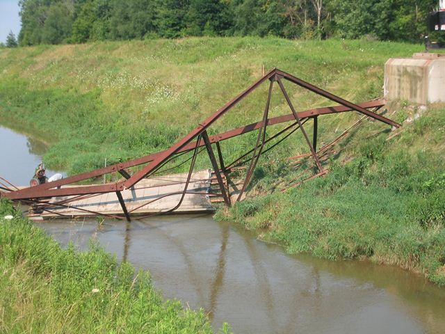
This historic bridge was demolished by the Sanilac County Road Commission on July 28, 2004!
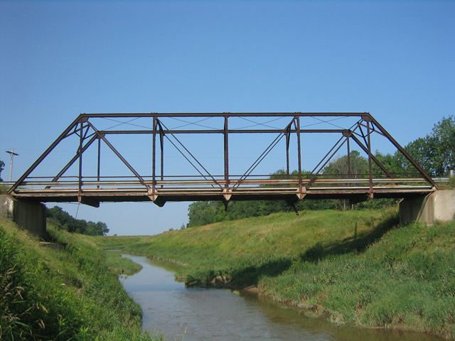
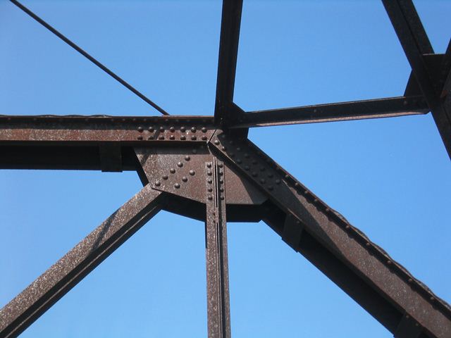
The Church Road bridge was a Pratt through truss bridge and had six panels and riveted connections. It sat on concrete abutments, with former random rubble abutments visible behind the concrete. The deck of the bridge was asphalt on corrugated steel, resting on steel i-beam deck stringers. It appeared to retain its original channel guardrails above the modern Armco style guardrails below.
The local newspaper had a tiny article mentioning the demolition of this bridge and said the bridge was built in 1904. The Michigan Historic Bridge Inventory apparently was unsure of a construction date and put a ca. 1920 construction date on it. The inventory also associated the Continental Bridge Company of Chicago and Peotone, Illinois as the builder of the bridge. 1920 seemed a bit late for a bridge of this design in Michigan, while 1904 would have made it among the earliest examples of a rivet-connected truss bridge in Michigan.
Whether it was a twisted celebration of a centennial birthday, or merely a short-sighted and wasteful spending of tax dollars, Sanilac County felt the best way to deal with a historic bridge such as this was to wipe it off the face of the earth.
A person who lived near the bridge said that the he moved there in the 1940s, and that the bridge at that time had a concrete deck. He then explained that the final asphalt deck was installed some thirty years ago, which would be the 1970s. Based on the newish appearance of the deck stringers, it would appear that the deck stringers would have replaced at this time as well.
The abutments were a source of mystery as well. The concrete abutments were in good condition and almost looked newer than the bridge, while the old stone abutments behind the concrete looked old enough to have been from a previous bridge. Were the concrete abutments original to the metal truss bridge, or were the truss bridge's abutments redone at some point? No answers have ever been found.
Not having been painted for ages, the bridge had rusted considerably, and had complete section loss in several spots. However, the bridge had not deteriorated beyond feasible rehabilitation, either for light vehicular use, or as a potential candidate for relocation and reused as a crossing for non-motorized traffic. The road had an Average Daily Traffic of only 260. AASHTO guidelines suggest that roads with such a low ADT are "Very Low Volume Roadways" and as such tax dollars may not need to be wasted providing a massive two lane bridge. Instead, rehabilitating the historic bridge would have saved tax dollars and served the needs of this quiet road.
This bridge was Sanilac county's last through truss bridge when it was demolished. Today, Sanilac County has no metal truss bridges of any kind open on any public roads.
SLH Contracting of Corunna MI got the job of tearing the truss bridge down and building the replacement. HistoricBridges.org contacted them and expressed interest in witnessing and photographing the demolition. They were very friendly and had no problem with this. As a result, HistoricBridges.org has an extensive photo-documentation of the whole event that documents the end of the historic Church Road Bridge. In a more indirect way, these photos also document Sanilac County and the Sanilac County Road Commission, and the choice it made to destroy our nation's transportation heritage. Where some counties, such as Calhoun County, Kent County, Midland County, and Marquette County have made decisions that have left historic bridges standing, Sanilac County did not even make an attempt.

Above: View from same location as the top photo, after the replacement was complete.
![]()
Photo Galleries and Videos: Church Road Bridge
Structure Overview
Original / Full Size PhotosA collection of overview photos that show the bridge as a whole and general areas of the bridge. This gallery offers photos in the highest available resolution and file size in a touch-friendly popup viewer.
Alternatively, Browse Without Using Viewer
![]()
Structure Details
Original / Full Size PhotosA collection of detail photos that document the parts, construction, and condition of the bridge. This gallery offers photos in the highest available resolution and file size in a touch-friendly popup viewer.
Alternatively, Browse Without Using Viewer
![]()
Structure Overview
Mobile Optimized PhotosA collection of overview photos that show the bridge as a whole and general areas of the bridge. This gallery features data-friendly, fast-loading photos in a touch-friendly popup viewer.
Alternatively, Browse Without Using Viewer
![]()
Structure Details
Mobile Optimized PhotosA collection of detail photos that document the parts, construction, and condition of the bridge. This gallery features data-friendly, fast-loading photos in a touch-friendly popup viewer.
Alternatively, Browse Without Using Viewer
![]()
Bridge Demolition
Original / Full Size PhotosA collection of overview and detail photos documenting the demolition of this historic bridge. Some photos comparing the replacement bridge to the historic bridge are included in this gallery. This gallery offers photos in the highest available resolution and file size in a touch-friendly popup viewer.
Alternatively, Browse Without Using Viewer
![]()
Bridge Demolition
Mobile Optimized PhotosA collection of overview and detail photos documenting the demolition of this historic bridge. Some photos comparing the replacement bridge to the historic bridge are included in this gallery. This gallery features data-friendly, fast-loading photos in a touch-friendly popup viewer.
Alternatively, Browse Without Using Viewer
![]()
Bridge Demolition
Full Motion VideoBridge knocked into the river. Streaming video of the bridge. Also includes a higher quality downloadable video for greater clarity or offline viewing.
![]()
Bridge Demolition
Full Motion VideoCutting down sway bracing. Streaming video of the bridge. Also includes a higher quality downloadable video for greater clarity or offline viewing.
![]()
Bridge Demolition
Full Motion VideoDeck stringer removal. Streaming video of the bridge. Also includes a higher quality downloadable video for greater clarity or offline viewing.
![]()
Bridge Demolition
Full Motion VideoAttempting to pull parts out of the river. Streaming video of the bridge. Also includes a higher quality downloadable video for greater clarity or offline viewing.
![]()
Bridge Demolition
Full Motion VideoAttempting to pull parts out of the river. Streaming video of the bridge. Also includes a higher quality downloadable video for greater clarity or offline viewing.
![]()
Maps and Links: Church Road Bridge
This historic bridge has been demolished. This map is shown for reference purposes only.
Coordinates (Latitude, Longitude):
Search For Additional Bridge Listings:
Bridgehunter.com: View listed bridges within 0.5 miles (0.8 kilometers) of this bridge.
Bridgehunter.com: View listed bridges within 10 miles (16 kilometers) of this bridge.
Additional Maps:
Google Streetview (If Available)
GeoHack (Additional Links and Coordinates)
Apple Maps (Via DuckDuckGo Search)
Apple Maps (Apple devices only)
Android: Open Location In Your Map or GPS App
Flickr Gallery (Find Nearby Photos)
Wikimedia Commons (Find Nearby Photos)
Directions Via Sygic For Android
Directions Via Sygic For iOS and Android Dolphin Browser
USGS National Map (United States Only)
Historical USGS Topo Maps (United States Only)
Historic Aerials (United States Only)
CalTopo Maps (United States Only)


