We Recommend:
Bach Steel - Experts at historic truss bridge restoration.
BridgeHunter.com Phase 1 is released to the public! - Visit Now
Lake Street Bridge

Primary Photographer(s): Nathan Holth
Bridge Documented: August 12, 2006 and 2010 - May, 2012
Lake Street and Railroad (Chicago Transit Authority "L" Green and Pink Lines) Over South Branch Chicago River
Chicago: Cook County, Illinois: United States
Metal Rivet-Connected Warren Through Truss, Movable: Double Leaf Bascule (Fixed Trunnion) and Approach Spans: Metal Stringer (Multi-Beam), Fixed
1916 By Builder/Contractor: Ketler-Elliott Company of Chicago, Illinois and Engineer/Design: City of Chicago
1995
245.0 Feet (74.7 Meters)
333.0 Feet (101.5 Meters)
38 Feet (11.58 Meters)
1 Main Span(s) and 4 Approach Span(s)
16602926799

View Information About HSR Ratings
Bridge Documentation
View Archived National Bridge Inventory Report - Has Additional Details and Evaluation
About The Lake Street Bridge
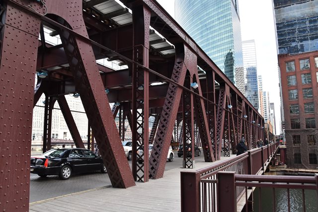
This fixed trunnion bascule bridge and its design is one of the finest and most impressive in the city of Chicago. Along with its near-twin on Wells Street, these are the only two movable bridges along the loop that carry the CTA "L" trains. These two bridges are also the only two double-deck bridges in Chicago that carry trains on one deck and vehicular traffic on the other deck. On both, the trains travel on the upper deck, allowed the already-elevated trains to seamlessly connect to the bridge at this level, while vehicular traffic travels on the lower deck. Sidewalks are also located on the lower deck. The double-deck configuration of the Lake Street Bridge makes for a very massive bridge. Because it is so massive, this bridge is very impressive to watch being raised or lowered. The Lake Street Bridge was built before Wells Street Bridge and as such the slight differences in the design and construction process of the Lake Street Bridge represent its prototypical nature, but overall the appearance of the two bridges is very similar. The Lake Street Bridge is technologically significant for its double-deck design, the first of its kind on the river when built.
Lake Street Bridge is the site of where Chicago's first crossing of the river was made, when a ferry was ordered at this location by the Commissioners of Peoria in 1829. Costs for crossing were listed in an Annual Report of the Department of Public Works as follows: Foot passenger: 6 1/4 cents, man and horse: 12 1/2 cents, horse and pleasure vehicle: 50 cents, one horse and wagon: 25 cents, two horse wagon: 37 1/2 cents, and each bushel of grain: 6 1/4 cents. The first documented bridge at Lake Street was built of wood in 1849. This bridge was rebuilt by N. Chapin in 1859, rebuilt by Fox and Howard as a wood/iron combination bridge. In 1885, an iron bridge was built by the Detroit Bridge Company. This bridge was converted into a double-deck bridge in 1893.
The design of the existing bascule bridge was not arrived at immediately. Early plans called for a vertical lift bridge at this location. The city had sought competitive plans and estimates for a bridge, and had those plans reviewed by City Engineer John Ericson, alongside J. E. Greiner (a noteworthy consulting engineer based out of Baltimore, Maryland) and Chicago and NorthWestern Railroad Acting Chief Engineer W. H. Finley. They arrived at the vertical lift design. However, the second choice, that of the bascule bridge was later decided upon for "reasons of public policy" according to the Annual Report of the Department of Public Works.
A Virtual Tour: The Lake Street Bridge Tender House Control Room and Machinery Basement
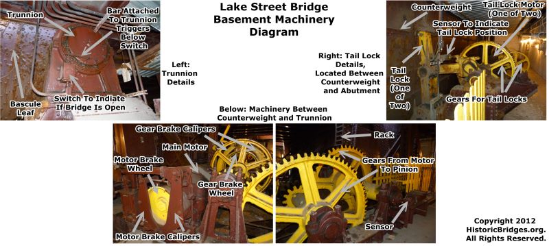
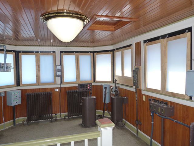
The Chicago Department of Transportation's Michelle Woods was kind enough to arrange a few moments out of her very busy schedule to give HistoricBridges.org a brief tour of the Lake Street Bridge's bridge tender house control room and machinery basement, following a similar tour provided to a school group. In addition, for comparison, a brief visit to the control room of the nearby modern Randolph Street Bridge provided a comparison to how the control rooms have changed from the era of the historic bridges to the modern bridges. Some of Chicago's bridge tender houses were documented in black-and-white photos by the Historic American Engineering Record in a minimal fashion, however HistoricBridges.org is proud to be the first bridge website to provide a complete set of full-color digital photos of a Chicago bridge tender house's interior. While there undoubtedly are variations between the bridge tender houses and associated operating equipment between Chicago's many historic movable bridges, the tour provided for this bridge is intended to not only document the Lake Street Bridge, but to provide an overview of the general type and design of equipment likely found in many other movable Chicago bridges. The Lake Street Bridge retains original design control house operating equipment, and the mechanics in the basement are largely unchanged from the original design as well. The only significant updates appear to have been changes to the sensor equipment in the basement, and the addition of a device that relays the status of the bridge locks to a nearby CTA control tower, so that the CTA knows when the stop or start running trains on the bridge.
A full tour of the bridge tender house control room and machinery is available as one of the photo galleries available for this bridge. Additionally, the below two diagrams are available.
Bridge Construction and Previous Bridge
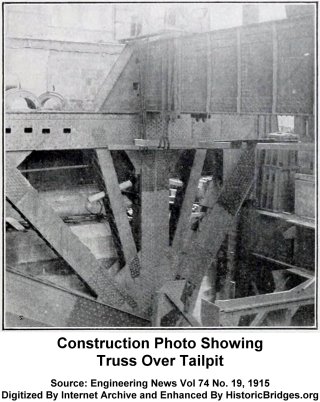
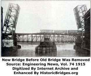
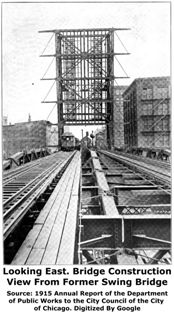
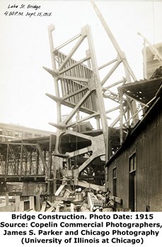
The construction of this bridge was innovative in that City engineers designed a way to construct this bridge while maintaining traffic on the previous swing bridge at the location. The bascule leafs were constructed in the raised position around the old swing bridge, with the ends of the deck left off the bridge to allow traffic to pass through onto the old bridge during construction. Other considerations for accomodating the needs of both the old bridge and the new bridge construction were made, requiring such activities as temporary supports for sections of the old bridge. The practice of maintaining traffic on a former bridge, while constructing a replacement bridge on the same alignment was common among railroads, but uncommon for the city engineers, and the double-deck design undoubtedly introduced a unique level of complication to the project. As such, the construction of this bridge as well as the nearby Wells Street Bridge represent some of the most complex and creative engineering projects ever undertaken by the City of Chicago.
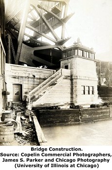
Above: These photos show the construction of the bridge. Because the former bridge was kept in service during construction, the design of the previous bridge can be discerned from these photographs.
Above: The above photos shows the process used to transfer traffic from the previous swing bridge to the bascule bridge with minimal disruption of traffic. This involved demolishing the center portion of of the swing bridge when in the open position, which allowed the bascule span to be lowered and opened to traffic quickly. Then, the rest of the swing span could be demolished without a rush.
In 1886, Volume 15 of the Engineering News-Record described the construction of the swing bridge that preceded the current bascule bridge. The text of the short paragraph follows.
Lake Street Bridge. --- The iron swing bridge over the Chicago river at Lake street, Chicago, is completed, but the viaduct and approaches are not yet finished The bridge is 220 feet long. 23 feet high in center, and 20 feet high at ends; it has a width of 60 feet, composed of two 21-feet roadways and two 7-feet sidewalks: the floor will carry a weight of 125 pounds per square foot: The drum on which the bridge turns is 48 feet in diameter, and rests on 74 solid iron wheel-, 18 inches diameter and 8 inches wide on face: the gearing is of phosphor bronze. The bridge will be turned by a steam engine with a pair of 8-in. by 12 in. cylinders, and a 7-inch cylinder engine will be used to drive the electric light plant: the engine-house is on top of the structure. The bridge will cost $145,000, divided equally between the city and the West Division Street R. R. Co.: the viaduct will cost $55,000. paid by the railroads interested: total cost, $200,000. Work was commenced in November last.
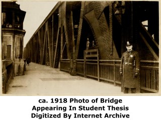
Above: Photos showing the newly constructed bridge.
Above: The Annual Report of the Public Works Department has a drawing of the bridge that showed several noteworthy details of the bridge, some of which were apparently not included in the final plans for the bridge, such as decorative details mounted on the trusses.

|
Main Plaque BUILT 1916WILLIAM HALE THOMPSON MAYOR
JOHN ERICSON CITY ENGINEER THOMAS G. PIHLDELDT ENGINEER OF BRIDGES
CHICAGO PLAN COMMISSION, E. H. BENNETT, ARCH'T.
|
Historical Articles
View A Historical Article Discussing The Construction of Lake Street Bridge
View A More Detailed Historical Article Discussing The Construction of Lake Street Bridge
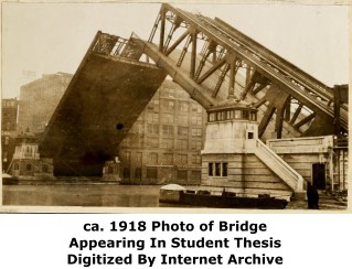
View A Historical Thesis Paper Discussing The Lake Street Bridge
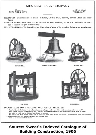
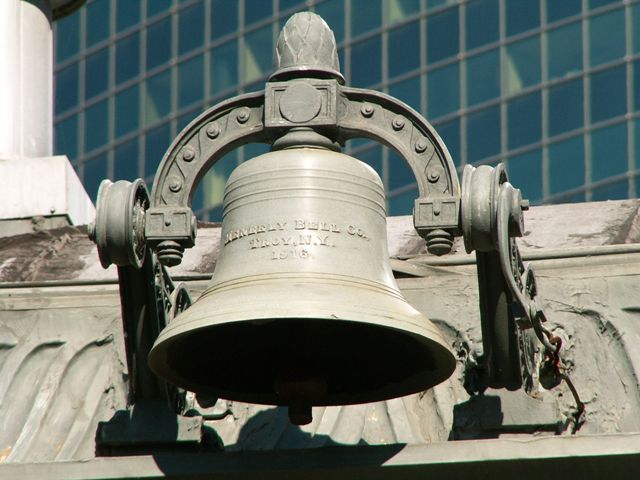
View A Historical Meneely Bell Company Catalog
![]()
Historic Bridges of Chicago and Cook County


Chicago and Cook County are home to one of the largest collections of historic bridges in the country, and no other city in the world has more movable bridges. HistoricBridges.org is proud to offer the most extensive coverage of historic Chicago bridges on the Internet.
General Chicago / Cook County Bridge Resources
Chicago's Bridges - By Nathan Holth, author of HistoricBridges.org, this book provides a discussion of the history of Chicago's movable bridges, and includes a virtual tour discussing all movable bridges remaining in Chicago today. Despite this broad coverage, the book is presented in a compact format that is easy to take with you and carry around for reference on a visit to Chicago. The book includes dozens of full color photos. Only $9.95 U.S! ($11.95 Canadian). Order on Amazon.
Chicago River Bridges - By Patrick T. McBriarty, this is a great companion to Holth's book shown above. This much larger book offers an extremely in-depth exploration of Chicago's movable highway bridges, including many crossings that have not existed for many years. Order Now Direct From The Publisher! or order on Amazon.
View Historic American Engineering Record (HAER) Overview of Chicago Bascule Bridges (HAER Data Pages, PDF)
Chicago Loop Bridges - Chicago Loop Bridges is another website on the Internet that is a great companion to the HistoricBridges.org coverage of the 18 movable bridges within the Chicago Loop. This website includes additional information such as connections to popular culture, overview discussions and essays about Chicago's movable bridges, additional videos, and current news and events relating to the bridges.
Additional Online Articles and Resources - This page is a large gathering of interesting articles and resources that HistoricBridges.org has uncovered during research, but which were not specific to a particular bridge listing.
This bridge is tagged with the following special condition(s): Double-Deck
![]()
Photo Galleries and Videos: Lake Street Bridge
Structure Overview
Original / Full Size PhotosA collection of overview photos that show the bridge as a whole and general areas of the bridge. This gallery offers photos in the highest available resolution and file size in a touch-friendly popup viewer.
Alternatively, Browse Without Using Viewer
![]()
Structure Details
Original / Full Size PhotosA collection of detail photos that document the parts, construction, and condition of the bridge. This gallery offers photos in the highest available resolution and file size in a touch-friendly popup viewer.
Alternatively, Browse Without Using Viewer
![]()
Bridge Tender House and Basement
Original / Full Size PhotosA virtual tour of the bridge tender house control room, where the controls that operate the bridge are located, and the basement machinery room, where the motors and gears that raise and lower the bridge are located. This gallery offers photos in the highest available resolution and file size in a touch-friendly popup viewer.
Alternatively, Browse Without Using Viewer
![]()
Structure Overview
Mobile Optimized PhotosA collection of overview photos that show the bridge as a whole and general areas of the bridge. This gallery features data-friendly, fast-loading photos in a touch-friendly popup viewer.
Alternatively, Browse Without Using Viewer
![]()
Structure Details
Mobile Optimized PhotosA collection of detail photos that document the parts, construction, and condition of the bridge. This gallery features data-friendly, fast-loading photos in a touch-friendly popup viewer.
Alternatively, Browse Without Using Viewer
![]()
Bridge Tender House and Basement
Mobile Optimized PhotosA virtual tour of the bridge tender house control room, where the controls that operate the bridge are located, and the basement machinery room, where the motors and gears that raise and lower the bridge are located. This gallery features data-friendly, fast-loading photos in a touch-friendly popup viewer.
Alternatively, Browse Without Using Viewer
![]()
Additional Unorganized Photos
Original / Full Size PhotosA supplemental collection of photos that are from additional visit(s) to the bridge and have not been organized or captioned. This gallery offers photos in the highest available resolution and file size in a touch-friendly popup viewer.
Alternatively, Browse Without Using Viewer
![]()
Additional Unorganized Photos
Mobile Optimized PhotosA supplemental collection of photos that are from additional visit(s) to the bridge and have not been organized or captioned. This gallery features data-friendly, fast-loading photos in a touch-friendly popup viewer.
Alternatively, Browse Without Using Viewer
![]()
Raising Bridge, View Beside
Full Motion VideoTaken 2017. View from southeast quadrant. Streaming video of the bridge. Also includes a higher quality downloadable video for greater clarity or offline viewing.
![]()
Raising Bridge, View Beside
Full Motion VideoTaken June 2011. View from southeast quadrant. Streaming video of the bridge. Also includes a higher quality downloadable video for greater clarity or offline viewing.
![]()
Raising Bridge, View Beside
Full Motion VideoTaken June 2013. View from southwest quadrant. Streaming video of the bridge. Also includes a higher quality downloadable video for greater clarity or offline viewing.
![]()
Raising Bridge, Fisheye View Beside
Full Motion VideoTaken June 2013. View from southwest quadrant. Streaming video of the bridge. Also includes a higher quality downloadable video for greater clarity or offline viewing.
![]()
Lowering Bridge, Elevation
Full Motion VideoTaken June 2011. Streaming video of the bridge. Also includes a higher quality downloadable video for greater clarity or offline viewing.
![]()
Raising The Bridge
Full Motion VideoStreaming video of the bridge. Also includes a higher quality downloadable video for greater clarity or offline viewing.
![]()
Lowering The Bridge
Full Motion VideoStreaming video of the bridge. Also includes a higher quality downloadable video for greater clarity or offline viewing.
![]()
Maps and Links: Lake Street Bridge
Coordinates (Latitude, Longitude):
Search For Additional Bridge Listings:
Bridgehunter.com: View listed bridges within 0.5 miles (0.8 kilometers) of this bridge.
Bridgehunter.com: View listed bridges within 10 miles (16 kilometers) of this bridge.
Additional Maps:
Google Streetview (If Available)
GeoHack (Additional Links and Coordinates)
Apple Maps (Via DuckDuckGo Search)
Apple Maps (Apple devices only)
Android: Open Location In Your Map or GPS App
Flickr Gallery (Find Nearby Photos)
Wikimedia Commons (Find Nearby Photos)
Directions Via Sygic For Android
Directions Via Sygic For iOS and Android Dolphin Browser
USGS National Map (United States Only)
Historical USGS Topo Maps (United States Only)
Historic Aerials (United States Only)
CalTopo Maps (United States Only)


