

View Information About HSR Ratings
This bridge was originally built in 1923 on Telegraph Road over the Middle River Rouge, but was moved a long time ago, in 1933 to its current location.
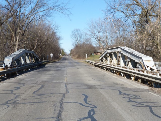
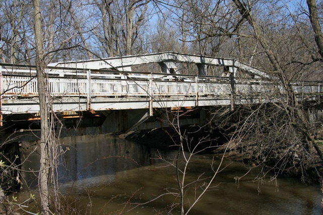
This bridge is an eight panel Pratt pony truss with riveted connections. It retains original guardrails on both the roadway and the sidewalk, although modern Armco guardrails have been added in front of the original roadway guardrails. The bridge has v-lacing on diagonal members, and lattice on the top and bottom of the top chord. The bridge sits on concrete abutments. The bridge was sandblasted and painted in 1995, although it really doesn't show today. Although the majority of the bridge is still good, there is some bad rust damage, most likely initiated by salt application, on several parts of the bridge including the railing and lattice. The bridge should be considered a good candidate for rehabilitation, repainting, and continued vehicular use in this location.
Information and Findings From Michigan Historic Sites OnlineNarrative Description main span number: 1 main span length: 84.0 structure length: 90.0 roadway width: 44.0 structure width: 27.0 Lilley Road, which runs north-south, passes over the Lower Rouge River just north of Michigan Avenue (US-12). The road is in western Wayne County, about midway between Detroit and Ann Arbor. Once rural, the area is now experiencing residential and other development, probably stimulated by Interstate 96 not far to the east. Lilley Road Bridge is a camelback pony truss comprised of the following elements: upper chord: back-to-back channels tied by X-lacing (top and bottom); lower chord: Channels with battens; verticals: built-up I beam; diagonals: paired angles with V-lacing; railings: bars riveted to angles; bottom lateral: paired angles; new I-beam stringers; built-up I-beam floor beams riveted to superstructure; steel maker's mark: Carnegie USA. Sidewalks rest on metal brackets outside of the trusses. Statement of Significance Under the provisions of the McNitt Act, Wayne County took over responsibility from Canton Township of two narrow, dilapidated, steel bridges along Lilley Road in 1933. One bridge crossed the main channel of the Lower Rouge River; the other spanned an overflow channel about 400 feet away. The county road commission immediately embarked on a project to improve the crossing, first significantly changing the channel to require only one structure. They then installed a skewed truss, which had just been removed from the Telegraph Road crossing of a branch of the Rouge River, north of Warren Road. The truss was no longer suitable for Telegraph Road, which was being widened. It was originally fabricated and erected in 1923-1924 by the Massillon Bridge Company of Massillon, Ohio. County crews did related site work on Telegraph Road, resulting in a total expense of $20,885 on the project during that fiscal year. In the same period, the county erected "practically a duplicate" pony truss on Telegraph Road over the Rouge River, about three miles to the south. The latter bridge is pictured in the road commission's 1923-1924 annual report. The superstructure, which appears essentially identical to the Lilley Road Bridge, has a cantilevered sidewalk and railings; concrete balustrades with urn-shaped spindles edge the approaches. When the Lilley Road Bridge was surveyed in 1995, a contractor had sandblasted and primed the superstructure, and was in the process of repainting it. When the Telegraph Road Bridge was moved to Lilley Road in 1933, its historical integrity was maintained. As well-documented example of a 1920s pony truss, this bridge is eligible for the National Register under Criterion C. |
This bridge is tagged with the following special condition(s): Unorganized Photos
![]()
![]()
![]()
![]()
![]()
This historic bridge has been demolished. This map is shown for reference purposes only.
Coordinates (Latitude, Longitude):
Search For Additional Bridge Listings:
Bridgehunter.com: View listed bridges within 0.5 miles (0.8 kilometers) of this bridge.
Bridgehunter.com: View listed bridges within 10 miles (16 kilometers) of this bridge.
Additional Maps:
Google Streetview (If Available)
GeoHack (Additional Links and Coordinates)
Apple Maps (Via DuckDuckGo Search)
Apple Maps (Apple devices only)
Android: Open Location In Your Map or GPS App
Flickr Gallery (Find Nearby Photos)
Wikimedia Commons (Find Nearby Photos)
Directions Via Sygic For Android
Directions Via Sygic For iOS and Android Dolphin Browser
USGS National Map (United States Only)
Historical USGS Topo Maps (United States Only)
Historic Aerials (United States Only)
CalTopo Maps (United States Only)

© Copyright 2003-2026, HistoricBridges.org. All Rights Reserved. Disclaimer: HistoricBridges.org is a volunteer group of private citizens. HistoricBridges.org is NOT a government agency, does not represent or work with any governmental agencies, nor is it in any way associated with any government agency or any non-profit organization. While we strive for accuracy in our factual content, HistoricBridges.org offers no guarantee of accuracy. Information is provided "as is" without warranty of any kind, either expressed or implied. Information could include technical inaccuracies or errors of omission. Opinions and commentary are the opinions of the respective HistoricBridges.org member who made them and do not necessarily represent the views of anyone else, including any outside photographers whose images may appear on the page in which the commentary appears. HistoricBridges.org does not bear any responsibility for any consequences resulting from the use of this or any other HistoricBridges.org information. Owners and users of bridges have the responsibility of correctly following all applicable laws, rules, and regulations, regardless of any HistoricBridges.org information.
![]()