We Recommend:
Bach Steel - Experts at historic truss bridge restoration.
BridgeHunter.com Phase 1 is released to the public! - Visit Now
New Boston Bridge
Waltz Road Bridge

Primary Photographer(s): Nathan Holth and Rick McOmber
Bridge Documented: August 1, 2005 and September 5, 2009
New Boston: Wayne County, Michigan: United States
1924 By Builder/Contractor: Mount Vernon Bridge Company of Mount Vernon, Ohio and Engineer/Design: Michigan State Highway Department
1961
99.7 Feet (30.4 Meters)
207.0 Feet (63.1 Meters)
27 Feet (8.23 Meters)
2 Main Span(s)
82200137000B020

View Information About HSR Ratings
Bridge Documentation
This bridge no longer exists!
Bridge Status: Demolished and replaced in 2018.View Archived National Bridge Inventory Report - Has Additional Details and Evaluation
Original Bridge Plans, PDF
This bridge is similar to the one-span Lilley Road Bridge also in Wayne County, and the M-65 Bridge in Iosco County. This bridge is not as large as M-65, which is two-span also, but retains its original railings, increasing its historic significance. M-65 originally had railings just like the ones on this bridge. Michigan had developed a standard plan for pony trusses, and all three of these bridges are examples of this plan. Each one is a bit different however, mainly in terms of length, and as a result, the top chord's shape and the number of panels.
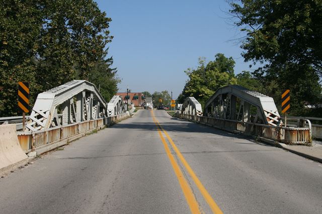
The New Boston Bridge is a two-span Pratt pony truss with seven panels on each span. The bridge is skewed, adding to its complexity and engineering significance. The top chord has some lattice above and below. V-lacing is on diagonal members. The bridge sits on concrete abutments, which, as MDOT mentions, have had their railings redone. The bridge itself retains it original standard 1920s truss bridge railings, and has had no modern railings added. However, original concrete balustrade railings on the abutment (perhaps similar to balustrade railings found on other Wayne County bridges) were removed and replaced with ugly modern railing. The bridge was built in 1924. MDOT says a plaque was once on the bridge (it has since been stolen), which identified the Mount Vernon Bridge Company from Mt. Vernon Ohio with building the bridge, as well as Swingle & Robinson Contractors with building the substructure. This is the same company that built the Martin Road Bridge decades earlier. There is some rust on the bridge, but the paint job is still for the most part good, and as of 2012 the bridge retained good ratings in the National Bridge Inventory. There are cantilevered sidewalks on both sides of this bridge that are original. The bridge is significant for having retained its truss railings, which although it was once a standard railing, is quite hard to find today, especially unmodified and/or not badly rusted.
Information and Findings From Michigan Historic Bridge InventoryNarrative Description The Waltz Road Bridge was one of 15 bridges constructed by Wayne County during the road commission's 1924-1925 fiscal year. The bridge was built at the same time that the county paved a 3.5-mile section of Waltz Road between Willow Road and New Boston. The road commission's annual report noted that grading and construction of drainage structures on the section were finished in 1924, "as also was the acquisition of 1 mile of new right-of-way necessary to eliminate bad curves and give a proper approach to the new bridge." No detour or temporary vehicular bridge were provided during the construction of the new bridge "because of the prohibitive cost" and "the light volume of traffic involved." A temporary pedestrian bridge, however, was built for the benefit of local school children. A bridge plate, which is no longer extant, identified the builder of the superstructure as the Mt. Vernon Bridge Company of Mt. Vernon, Ohio, and credited Swingle & Robinson, contractors from Wyandotte, Michigan, with the substructure. The newly completed span, which cost approximately $67,500, was pictured in the road commission's 1924-1925 annual report. The oblique elevation view, shot from below the level of the deck, highlighted "the massive steel and concrete work." The design was soon tested, when a dam upstream at French Landing failed and caused the river to flood. The structure easily withstood the onslaught. Railings over the abutments were originally concrete balustrades with urn-shaped spindles. Although these railings no longer exist, the bridge otherwise retains very good integrity. Statement of Significance The Waltz Road Bridge is eligible for the National Registeras an excellent example of 1920s pony truss construction, It is also eligible as a representative product of the Wayne County Road Commission from the 1920s era. |
![]()
Photo Galleries and Videos: New Boston Bridge
Bridge Photo-Documentation
Original / Full Size PhotosA collection of overview and detail photos. This gallery offers photos in the highest available resolution and file size in a touch-friendly popup viewer.
Alternatively, Browse Without Using Viewer
![]()
Bridge Photo-Documentation
Mobile Optimized PhotosA collection of overview and detail photos. This gallery features data-friendly, fast-loading photos in a touch-friendly popup viewer.
Alternatively, Browse Without Using Viewer
![]()
Maps and Links: New Boston Bridge
This historic bridge has been demolished. This map is shown for reference purposes only.
Coordinates (Latitude, Longitude):
Search For Additional Bridge Listings:
Bridgehunter.com: View listed bridges within 0.5 miles (0.8 kilometers) of this bridge.
Bridgehunter.com: View listed bridges within 10 miles (16 kilometers) of this bridge.
Additional Maps:
Google Streetview (If Available)
GeoHack (Additional Links and Coordinates)
Apple Maps (Via DuckDuckGo Search)
Apple Maps (Apple devices only)
Android: Open Location In Your Map or GPS App
Flickr Gallery (Find Nearby Photos)
Wikimedia Commons (Find Nearby Photos)
Directions Via Sygic For Android
Directions Via Sygic For iOS and Android Dolphin Browser
USGS National Map (United States Only)
Historical USGS Topo Maps (United States Only)
Historic Aerials (United States Only)
CalTopo Maps (United States Only)

