We Recommend:
Bach Steel - Experts at historic truss bridge restoration.
BridgeHunter.com Phase 1 is released to the public! - Visit Now
Nicol Road Bridge

Primary Photographer(s): Nathan Holth and Luke Gordon
Bridge Documented: June 7, 2004 and April 20, 2005
Rural: Sanilac County, Michigan: United States
Not Available or Not Applicable
66.0 Feet (20.1 Meters)
70.0 Feet (21.3 Meters)
20 Feet (6.1 Meters)
1 Main Span(s)
74305H00006B010

View Information About HSR Ratings
Bridge Documentation
This bridge no longer exists!
View Archived National Bridge Inventory Report - Has Additional Details and Evaluation

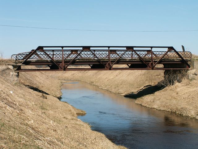
This bridge was the last truss bridge on public roads in Sanilac County. Cash Road Bridge was moved onto private property, and Church Road Bridge is destroyed. The remote Nicol Road Bridge, which carried little traffic, and had become a rare piece of Sanilac County's transportation heritage, was torn down in spring of 2005.
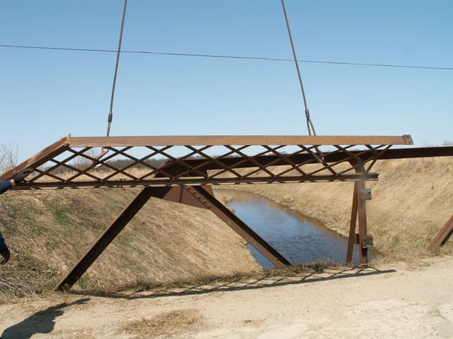
CR Hunt contractors who were hired by Sanilac County to replace the bridge were kind enough to provide the railings from this bridge, which HistoricBridges.org took and placed on a small private steel stringer bridge in St. Clair County. In this sense, a small portion of this historic bridge remains. Photos of the reused railings are available in one of the photo galleries.
Technical Information
This bridge was a Warren pony truss, and the connections were riveted. No v-lacing was present on any members, which was mostly composed of paired angles, a design that seems to have been quite popular in Michigan's Thumb area. However, due to the number of bridges like this remaining, this bridge had become rare and unique. It was built in 1905, according to the Michigan Historic Bridge Inventory. Sanilac County Road Commission decided the best way to celebrate this bridge's centennial year was to demolish it.
Historic Integrity
The Nicol Road Bridge appeared to retain a high degree of historic integrity. The deck was a jack-arch design: concrete poured on top of corrugated steel, and the guardrails were latticed. This all is in keeping with other Warren pony trusses of the time in this region. There appear to be have been no major modifications to this bridge, with the exception of a small repair to the guardrails, which was done by trying to weld and patch the existing lattice railings. It looked a like a car had taken a swipe at the bridge causing some damage to the railings. The bridge had a posted combination weight limit of 8-14-14 tons. The abutments of the bridge were concrete, and the bridge was set down into those abutments a bit, giving it a low appearance.
Excellent Trusses; Bad Abutments and Deck: Preservation Was Possible!

The abutments had deteriorated a quite a bit, and the bridge looked like it might eventually fall, because the concrete under the bearings of the bridge was falling away. The deck was also bad, and the corrugated steel was falling apart, which might have eventually caused the deck to fall out wherever the corrugated steel failed. Despite these problems, the actual truss structure's excellent condition was unparalleled among Michigan bridges. Despite a complete lack of paint, section loss and pack rust was nearly nonexistent on the bridge! This is a bridge that should not have been demolished and replaced. Instead, the deck should have been removed. Then, the abutments could either have been repaired, or the bridge could have been lifted off the river and new abutments constructed. The bridge could have been sandblasted and painted, although to save money this step could be skipped. On a dirt road miles away from winter deicing salts, the bridge appeared to have been acting like weathering steel, with the rust not causing any accelerated deterioration.
Sanilac County: Welcome to the Truss-Less List!
Since this bridge was small, and was the last Sanilac county truss bridge, and had historic and structural integrity, restoring this bridge should have been a no-brainer. Instead, Sanilac County acted with no brains, and went ahead and had the bridge demolished. Now Sanilac County has entered the list of truss-less counties. Once, metal truss bridges were one of the most common bridge types in America. During a period of rapid development in this nation, metal truss bridges were one of the most common types of bridge providing safe and reliable transportation. For a county to destroy the last remaining bridge of this type... and one that was feasible to preserve... shows a lack of respect for this country's heritage.
![]()
Photo Galleries and Videos: Nicol Road Bridge
Structure Overview
Original / Full Size PhotosA collection of overview photos that show the bridge as a whole and general areas of the bridge. This gallery offers photos in the highest available resolution and file size in a touch-friendly popup viewer.
Alternatively, Browse Without Using Viewer
![]()
Structure Details
Original / Full Size PhotosA collection of detail photos that document the parts, construction, and condition of the bridge. This gallery offers photos in the highest available resolution and file size in a touch-friendly popup viewer.
Alternatively, Browse Without Using Viewer
![]()
Structure Overview
Mobile Optimized PhotosA collection of overview photos that show the bridge as a whole and general areas of the bridge. This gallery features data-friendly, fast-loading photos in a touch-friendly popup viewer.
Alternatively, Browse Without Using Viewer
![]()
Structure Details
Mobile Optimized PhotosA collection of detail photos that document the parts, construction, and condition of the bridge. This gallery features data-friendly, fast-loading photos in a touch-friendly popup viewer.
Alternatively, Browse Without Using Viewer
![]()
Demolition, Replacement, and Railing Reuse
A collection of photos showing the demolition of the bridge, photos of the replacement bridge for comparison, and the reuse of the bridge's railings on a private bridge in St. Clair County. This photo gallery contains a combination of Original Size photos and Mobile Optimized photos in a touch-friendly popup viewer.Alternatively, Browse Without Using Viewer
![]()
Maps and Links: Nicol Road Bridge
This historic bridge has been demolished. This map is shown for reference purposes only.
Coordinates (Latitude, Longitude):
Search For Additional Bridge Listings:
Bridgehunter.com: View listed bridges within 0.5 miles (0.8 kilometers) of this bridge.
Bridgehunter.com: View listed bridges within 10 miles (16 kilometers) of this bridge.
Additional Maps:
Google Streetview (If Available)
GeoHack (Additional Links and Coordinates)
Apple Maps (Via DuckDuckGo Search)
Apple Maps (Apple devices only)
Android: Open Location In Your Map or GPS App
Flickr Gallery (Find Nearby Photos)
Wikimedia Commons (Find Nearby Photos)
Directions Via Sygic For Android
Directions Via Sygic For iOS and Android Dolphin Browser
USGS National Map (United States Only)
Historical USGS Topo Maps (United States Only)
Historic Aerials (United States Only)
CalTopo Maps (United States Only)


