We Recommend:
Bach Steel - Experts at historic truss bridge restoration.
BridgeHunter.com Phase 1 is released to the public! - Visit Now
North Park Street Bridge
Primary Photographer(s): Nathan Holth
Bridge Documented: March 6, 2006, November 5, 2011, and September 7, 2014
Grand Rapids: Kent County, Michigan: United States
1903 By Builder/Contractor: New Jersey Bridge Company of Manasquan, New Jersey
1991
116.0 Feet (35.4 Meters)
116.0 Feet (35.4 Meters)
19 Feet (5.79 Meters)
1 Main Span(s)
414278400288B01

View Information About HSR Ratings
Bridge Documentation
View Historic American Engineering Record (HAER) Documentation For This Bridge
HAER Data Pages, PDF
The Origins of the Span
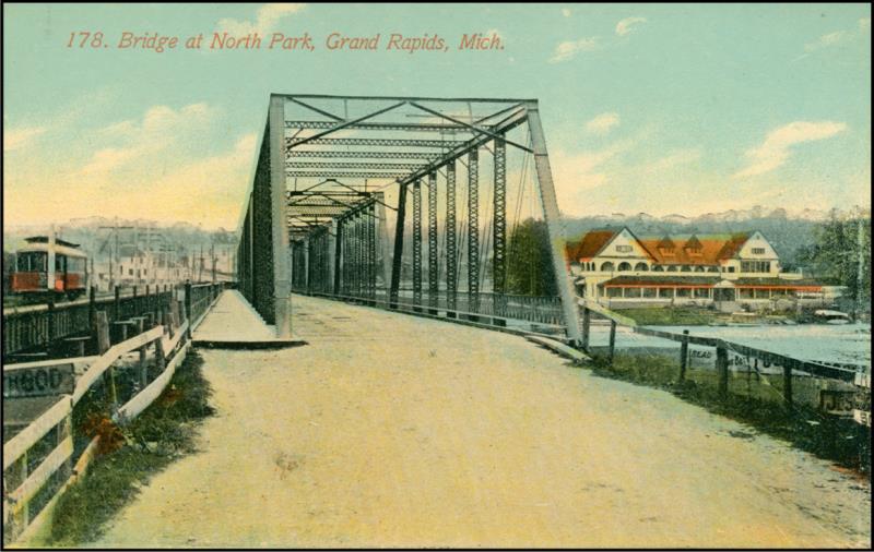
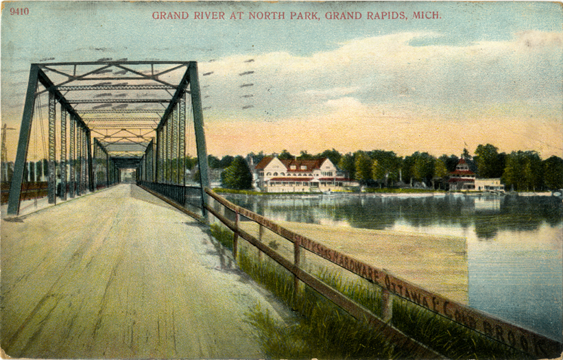
How can you demolish and restore a bridge at the same time? Here is how. This single span came from what was one of the longest and most significant historic metal truss bridges in Michigan. Located a short distance north of where this bridge stands, it carried North Park Street over the Grand River. It was five spans in length. Each span was 116 feet, yielding a whopping 580 foot long bridge, very long by Michigan standards! This bridge was demolished and replaced in 1991 representing a devastating loss of transportation heritage. It would have been nice to see that bridge left standing next to its replacement for pedestrian use. Unfortunately, that was not done. The only good news is that one of the spans was spared from the dumpster and was moved here and restored to serve this attractive city park.
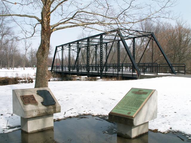
The only surviving, and partly broken plaque from the bridge was retained and mounted near the restored bridge along with interpretive and ceremonial plaques.
The plaque credits the New Jersey Bridge Company with building the bridge in 1903. This bridge was one of the only known surviving examples of this company in the entire country!
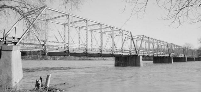
View of Original Bridge. Photo Credit: Historic American Engineering Record.
Technical Descriptions of the Span
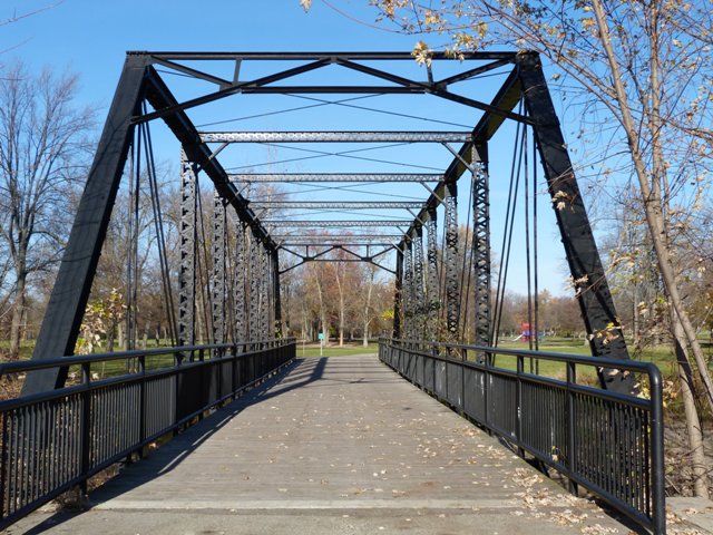
The span today is an eight panel pin connected through truss. The structure is 116 feet in length. Mill marks all over the bridge credit the Phoenix Company with providing the steel for the bridge. This Phoenix company is related to the Phoenix Iron Company which produced the famous Phoenix Columns like those seen on the Williams Road Bridge in Pennsylvania. However, Phoenix also produced simple rolled materials like those found on this bridge as well. For a pin-connected truss bridge, the bridge has a wide feeling to it, since it was built to support two lanes of traffic. Pin connected truss bridges like this are usually thought of as one-lane structures, but the truth is sometimes they were built to handle two lanes particularly in urban locations. Today, so few urban pin-connected truss bridges remain compared to the rural one-lane bridges that the urban ones tend to have a wide appearance when viewed by people who visit numerous bridges of this type. Portal bracing on the bridge is an a-frame style, with a couple pieces of steel riveted on to make it look different than the standard A-frame. V-lacing is present on vertical members, sway bracing and under the top chord. However, for whatever reason, somebody altered the bridge by covering up the v-lacing under the top chord on the northern top chord. Oddly, they left the southern top chord alone. They also left the end post portions of the top chord alone. The restoration of the bridge also resulted in some other changes. The cantilevered sidewalk was removed. The deck is narrower than the original, and there is a gap between vertical members and the deck. The railings are not original, and the original railings were not retained The original ornamental lattice sidewalk railings should have been reused, either on this bridge (behind the modern railings if safety needs dictated) or even placed around the nearby interpretive kiosk next to the bridge. Since an entire five span bridge was removed, there would have been plenty to go around. The eyebars for some of the lighter rod diagonal members have been replaced and are not original.
Above: Historical postcards of bridge.
Above: Relocating the span when the bridge was replaced.
This bridge is tagged with the following special condition(s): Reused and Unorganized Photos
![]()
Photo Galleries and Videos: North Park Street Bridge
Bridge Photo-Documentation
A collection of overview and detail photos. This photo gallery contains a combination of Original Size photos and Mobile Optimized photos in a touch-friendly popup viewer.Alternatively, Browse Without Using Viewer
![]()
Additional Unorganized Photos
Original / Full Size PhotosA supplemental collection of photos that are from additional visit(s) to the bridge and have not been organized or captioned. This gallery offers photos in the highest available resolution and file size in a touch-friendly popup viewer.
Alternatively, Browse Without Using Viewer
![]()
Additional Unorganized Photos
Mobile Optimized PhotosA supplemental collection of photos that are from additional visit(s) to the bridge and have not been organized or captioned. This gallery features data-friendly, fast-loading photos in a touch-friendly popup viewer.
Alternatively, Browse Without Using Viewer
![]()
Maps and Links: North Park Street Bridge
Coordinates (Latitude, Longitude):
Search For Additional Bridge Listings:
Bridgehunter.com: View listed bridges within 0.5 miles (0.8 kilometers) of this bridge.
Bridgehunter.com: View listed bridges within 10 miles (16 kilometers) of this bridge.
Additional Maps:
Google Streetview (If Available)
GeoHack (Additional Links and Coordinates)
Apple Maps (Via DuckDuckGo Search)
Apple Maps (Apple devices only)
Android: Open Location In Your Map or GPS App
Flickr Gallery (Find Nearby Photos)
Wikimedia Commons (Find Nearby Photos)
Directions Via Sygic For Android
Directions Via Sygic For iOS and Android Dolphin Browser
USGS National Map (United States Only)
Historical USGS Topo Maps (United States Only)
Historic Aerials (United States Only)
CalTopo Maps (United States Only)

