We Recommend:
Bach Steel - Experts at historic truss bridge restoration.
BridgeHunter.com Phase 1 is released to the public! - Visit Now
Tidioute Bridge

Primary Photographer(s): Nathan Holth
Bridge Documented: July, 2006
Tidioute: Warren County, Pennsylvania: United States
1933 By Builder/Contractor: Bates and Rogers of Chicago, Illinois and Engineer/Design: Pennsylvania State Highway Department
2002
270.0 Feet (82.3 Meters)
551.0 Feet (167.9 Meters)
24 Feet (7.32 Meters)
2 Main Span(s)
610127011005910

View Information About HSR Ratings
Bridge Documentation
View Archived National Bridge Inventory Report - Has Additional Details and Evaluation

This bridge is quickly becoming one of the last metal truss bridges on the entire Allegheny River. The Allegheny River once had a large number of beautiful historic metal truss bridges on it, but one after another PennDOT has been demolishing each and every one.
Consisting of two ten panel Parker truss spans, this bridge is an excellent example of a Pennsylvania state standard truss bridge, following the beautiful and impressive design that the state used for larger span crossings. Key aesthetic features of the bridge design include extensive v-lacing and lattice on the built-up beams that compose the truss web and bracing, as well as heavy lattice portal bracing. As such, this bridge acts as a beautiful historic gateway for Tidioute.
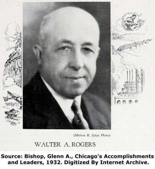
The bridge was fabricated by the Buffalo, NY works of the Lackawanna Steel Construction Company. Bates and Rogers of Chicago, Illinois was the local on-site contractor for the bridge. While the name might not be familiar in Pennsylvania, Bates and Rogers was formed in 1902 when Onward Bates left the Chicago, Milwaukee and St. Paul Railway where he was Superintendent of Bridges, and formed his own company alongside partner Walter A. Rogers. Click on the photo of Rogers at the end of this narrative to view a larger image that includes a short biography. A son named Lester C. Rogers also ran the company as president since 1937 after having been an engineer and vice president for the company. The company was still active with Lester Rogers as president in 1953.

Original plans for the Tidioute Bridge called for an initial shop coat of "red lead paint and oil", and two coats of paint in the field "per specs." These plans specified a total of 1,643,000 pounds of structural steel for the superstructure. The plans indicate that a previous structure existed on the site when the existing bridge was built, and that the superstructure above the piers was to be removed. The piers from this previous bridge were reused for the current bridge.
The Tidioute Bridge retains a high degree of historic and structural integrity, and with proper maintenance and rehabilitation as needed it will serve as a functional and historic crossing for decades to come. The only noteworthy alteration is the addition of concrete barrier guardrails and removal of original abutment balustrades.
The bridge is a very photogenic bridge and well worth a a visit; you can get good photos of this bridge south/west of the town of Tidioute on HWY-127. There is also a park near the bridge that also offers good side view shots of the bridge. The river valley is quite beautiful here, and goes well with the beauty of the bridge.

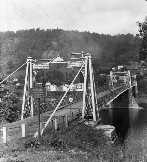
A previous bridge at Tidioute was a suspension bridge pictured above. Photo source: http://www.keystonemarkertrust.org/default.aspx?pg=96
Information and Findings From Pennsylvania's Historic Bridge InventoryDiscussion of Bridge The 1933, riveted, two span, 551'-long (1 @ 269', 1 @ 268') , Parker thru truss bridge is supported on a substructure that incorporates parts of an earlier ashlar substructure. The heavy trusses are composed from built up members. Built to a state standard design, the bridge has no innovative or distinctive details. It is an example of common technology, and and it is neither historically nor technologically significant. Discussion of Surrounding Area The bridge carries a 2 lane street and sidewalk over the Allegheny River in Tidioute, two blocks south of the National Register-listed Main Street Historic District. In between are late 20th century infill buildings and parking lots. To the southwest is a small, post-WW II commercial area. Southeast is more rural in character. Bridge Considered Historic By Survey: No |
![]()
Photo Galleries and Videos: Tidioute Bridge
Bridge Photo-Documentation
A collection of overview and detail photos. This photo gallery contains a combination of Original Size photos and Mobile Optimized photos in a touch-friendly popup viewer.Alternatively, Browse Without Using Viewer
![]()
Maps and Links: Tidioute Bridge
Coordinates (Latitude, Longitude):
Search For Additional Bridge Listings:
Bridgehunter.com: View listed bridges within 0.5 miles (0.8 kilometers) of this bridge.
Bridgehunter.com: View listed bridges within 10 miles (16 kilometers) of this bridge.
Additional Maps:
Google Streetview (If Available)
GeoHack (Additional Links and Coordinates)
Apple Maps (Via DuckDuckGo Search)
Apple Maps (Apple devices only)
Android: Open Location In Your Map or GPS App
Flickr Gallery (Find Nearby Photos)
Wikimedia Commons (Find Nearby Photos)
Directions Via Sygic For Android
Directions Via Sygic For iOS and Android Dolphin Browser
USGS National Map (United States Only)
Historical USGS Topo Maps (United States Only)
Historic Aerials (United States Only)
CalTopo Maps (United States Only)


