

View Information About HSR Ratings
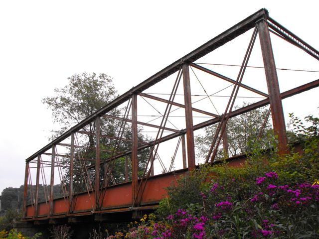
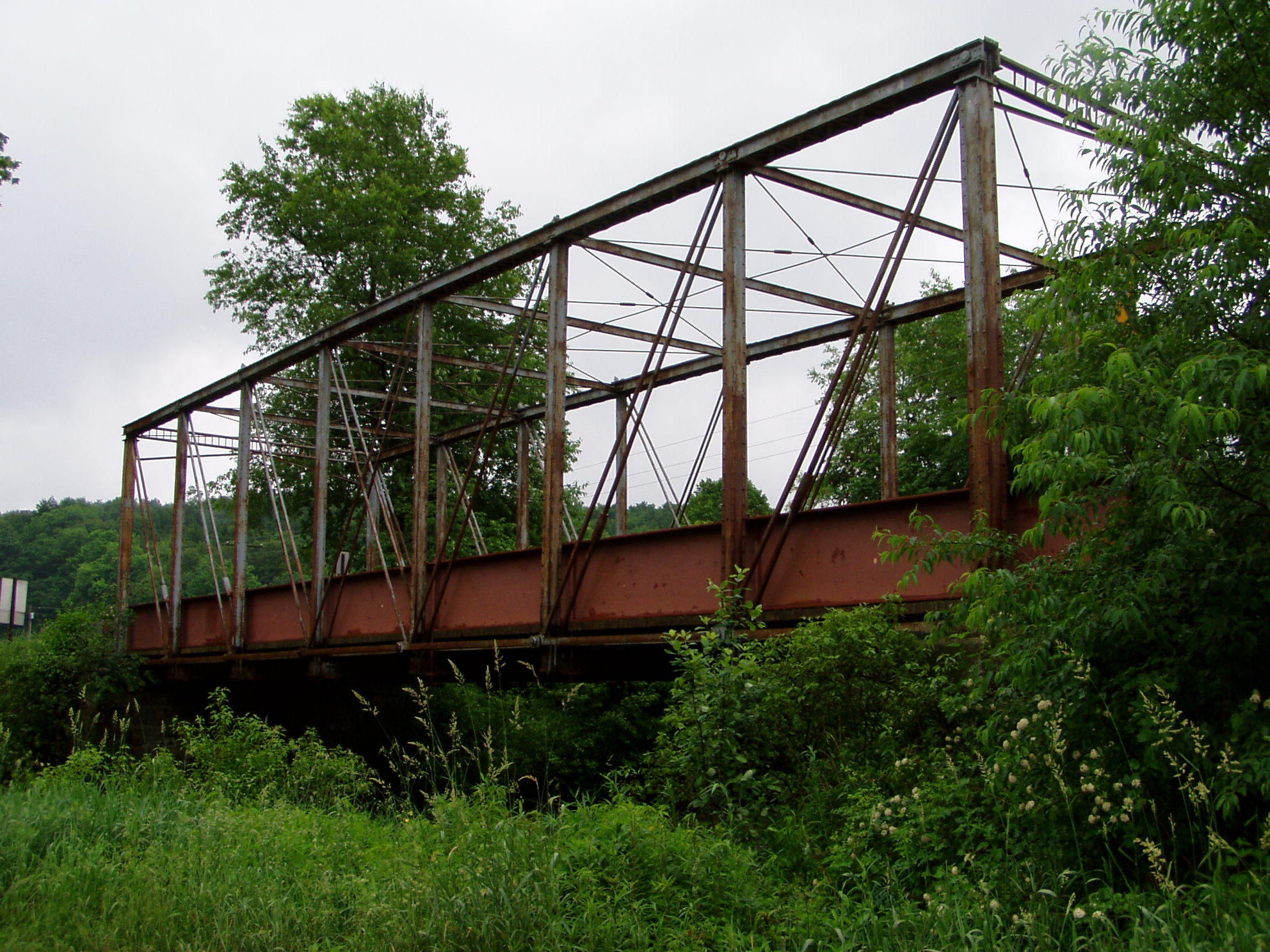
This bridge is a Pratt through truss, and is extremely significant because it uses Phoenix Columns. The Williams Road Bridge does not look like a traditional Phoenix column truss bridge like those built by Dean and Westbrook of New York for example. Instead, the Williams Road Bridge has its own extremely unusual design that does not use Phoenix's patented connections, and has vertical end posts. The very lightweight portal bracing is also extremely bizarre, composed of two channels with unusual rods between them. Two very lightweight angles also branch off of this to form the bracing knees. The bridge uses plate-like eyebars for the bottom chord, a design of eyebar that was common on the bowstring truss bridges that were popular during the 1870s. The first panel of bottom chord also has corrugated style lacing (sometimes called ribbon lacing). The top chord is for the most part a traditional built-up beam of two channels with cover plate, but the underside has lattice with each lattice section being separated by a narrow batten. The battens are bars of the same size as the lattice bars. This lattice/batten detail is very unusual. Because this bridge not only uses Phoenix columns, but is also presumed to be the only bridge in existence with all these unusual details and design, the bridge is among the most significant historic bridges in Pennsylvania.
The bridge was built in 1884 as the South Park Street over French Creek in Franklin. One span from that bridge was salvaged and relocated here to Williams Road in 1912.
Large i-beams have been added to the bridge to help support the bridge. Although perhaps visually unsightly, they do not appear to have altered the original materials or design of the bridge, and as such they do not diminish the historic significance of this bridge. Indeed, these beams have likely strengthened the bridge allowing it to continue to serve traffic, and they also help protect the bridge's trusses from collision damage.
Information and Findings From Pennsylvania's Historic Bridge InventoryDiscussion of Bridge The ca. 1880 bridge is a rare example of a pin connected Pratt thru truss bridge fabricated with Phoenix columns. It does not have the Phoenix Iron Co.'s patented connecting pieces, indicating that the columns were ordered from Phoenix but assembled into a bridge with local thinking about connections. A simple sleeve with pin plates has been used for both upper and lower panel point connections with those for the upper ones inside the built up upper chords. The bridge appears to be unaltered, and it is an important early example of truss bridge technology. It reflects the period of experimentation as reflected in the idiosyncratic details. The bridge may be unique. There is no makers plaque. Discussion of Surrounding Area The bridge carries a 2 lane unimproved township road over a stream in a rural area of active farms. Bridge Considered Historic By Survey: Yes |
This bridge is tagged with the following special condition(s): Phoenix Columns
![]()
![]()
![]()
![]()

![]()
Coordinates (Latitude, Longitude):
Search For Additional Bridge Listings:
Bridgehunter.com: View listed bridges within 0.5 miles (0.8 kilometers) of this bridge.
Bridgehunter.com: View listed bridges within 10 miles (16 kilometers) of this bridge.
Additional Maps:
Google Streetview (If Available)
GeoHack (Additional Links and Coordinates)
Apple Maps (Via DuckDuckGo Search)
Apple Maps (Apple devices only)
Android: Open Location In Your Map or GPS App
Flickr Gallery (Find Nearby Photos)
Wikimedia Commons (Find Nearby Photos)
Directions Via Sygic For Android
Directions Via Sygic For iOS and Android Dolphin Browser
USGS National Map (United States Only)
Historical USGS Topo Maps (United States Only)
Historic Aerials (United States Only)
CalTopo Maps (United States Only)

© Copyright 2003-2026, HistoricBridges.org. All Rights Reserved. Disclaimer: HistoricBridges.org is a volunteer group of private citizens. HistoricBridges.org is NOT a government agency, does not represent or work with any governmental agencies, nor is it in any way associated with any government agency or any non-profit organization. While we strive for accuracy in our factual content, HistoricBridges.org offers no guarantee of accuracy. Information is provided "as is" without warranty of any kind, either expressed or implied. Information could include technical inaccuracies or errors of omission. Opinions and commentary are the opinions of the respective HistoricBridges.org member who made them and do not necessarily represent the views of anyone else, including any outside photographers whose images may appear on the page in which the commentary appears. HistoricBridges.org does not bear any responsibility for any consequences resulting from the use of this or any other HistoricBridges.org information. Owners and users of bridges have the responsibility of correctly following all applicable laws, rules, and regulations, regardless of any HistoricBridges.org information.
![]()