

View Information About HSR Ratings
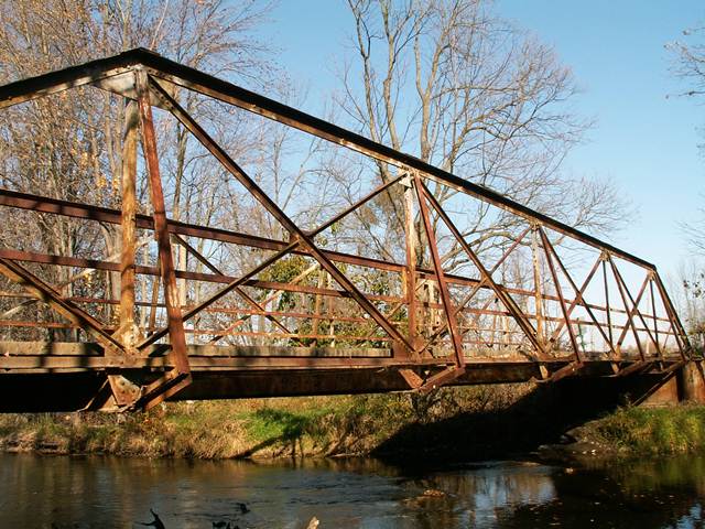
This bridge was an impressive pony truss, with a length over 80 feet, making it among the longest pony truss spans in Michigan. More significant however was its unusual design. First, it was composed of lightweight members, using angles as the primary rolled steel type. No channels, no v-lacing, and no lattice was found on this bridge as a result of using the lightweight angles instead. Also unusual was the double-Warren truss configuration. This was one of the few examples of this truss configuration in Michigan. The bridge was unaltered and had excellent historic integrity. It rested on caissons, and there was a plate steel retaining wall behind the caissons, the caissons and retaining wall combining to form an abutment system.
This bridge was actually open to traffic with a three ton weight limit. However, it could easily have been rehabilitated to support more weight. The bridge was overall not in very bad condition.
This bridge carried "traffic" on a dead-end road that served a few homes only. The listed Average Daily Traffic was listed as a mere 11. As mentioned before, this bridge could have easily been rehabilitated to have a much higher weight limit than three tons. But how did the St. Joseph County Road Commission decide to spend tax dollars? Instead, this bridge which was listed on the National Register of Historic Places, was demolished and replaced with a two lane bridge. This bridge could have likely been rehabilitated for far less than the cost of replacement. And a two-lane bridge on a dead-end road with an ADT of 11 serving a few homes is clearly an excessive waste of tax dollars. You can thank flawed federal and state funding programs for encouraging the road commissions to make such wasteful decisions. The road commission likely paid very little for this new bridge, since state and/or federal sources would have forked over the majority of the money. Regardless of the source however, this is your tax dollars. Is it wise to spend so much money to obliterate history when that history could have been preserved while also saving taxpayer money?
Finally, even if the bridge was to be replaced, it is most unfortunately that the road commission did not carefully dismantle this bridge and place it into storage as nearby Indiana does with many historic bridges it replaced. This would have kept the bridge available for reuse. The bridge could have been a great structure to restore and reuse on a non-motorized trail somewhere. However, the road commission did not place this bridge in storage. Nor does it appear to have contacted any of the people who work with historic bridges in Michigan to see if they would have been interested in preserving the bridge in a new location. Instead, they condemned it to the scrapyard.
A rendering of the replacement "bridge" if the ugly slab of concrete can be called such is shown below.
![]()
![]()
![]()
This historic bridge has been demolished. This map is shown for reference purposes only.
Coordinates (Latitude, Longitude):
Search For Additional Bridge Listings:
Bridgehunter.com: View listed bridges within 0.5 miles (0.8 kilometers) of this bridge.
Bridgehunter.com: View listed bridges within 10 miles (16 kilometers) of this bridge.
Additional Maps:
Google Streetview (If Available)
GeoHack (Additional Links and Coordinates)
Apple Maps (Via DuckDuckGo Search)
Apple Maps (Apple devices only)
Android: Open Location In Your Map or GPS App
Flickr Gallery (Find Nearby Photos)
Wikimedia Commons (Find Nearby Photos)
Directions Via Sygic For Android
Directions Via Sygic For iOS and Android Dolphin Browser
USGS National Map (United States Only)
Historical USGS Topo Maps (United States Only)
Historic Aerials (United States Only)
CalTopo Maps (United States Only)

© Copyright 2003-2025, HistoricBridges.org. All Rights Reserved. Disclaimer: HistoricBridges.org is a volunteer group of private citizens. HistoricBridges.org is NOT a government agency, does not represent or work with any governmental agencies, nor is it in any way associated with any government agency or any non-profit organization. While we strive for accuracy in our factual content, HistoricBridges.org offers no guarantee of accuracy. Information is provided "as is" without warranty of any kind, either expressed or implied. Information could include technical inaccuracies or errors of omission. Opinions and commentary are the opinions of the respective HistoricBridges.org member who made them and do not necessarily represent the views of anyone else, including any outside photographers whose images may appear on the page in which the commentary appears. HistoricBridges.org does not bear any responsibility for any consequences resulting from the use of this or any other HistoricBridges.org information. Owners and users of bridges have the responsibility of correctly following all applicable laws, rules, and regulations, regardless of any HistoricBridges.org information.
![]()